Travel

Postcards from the Isle of Skye

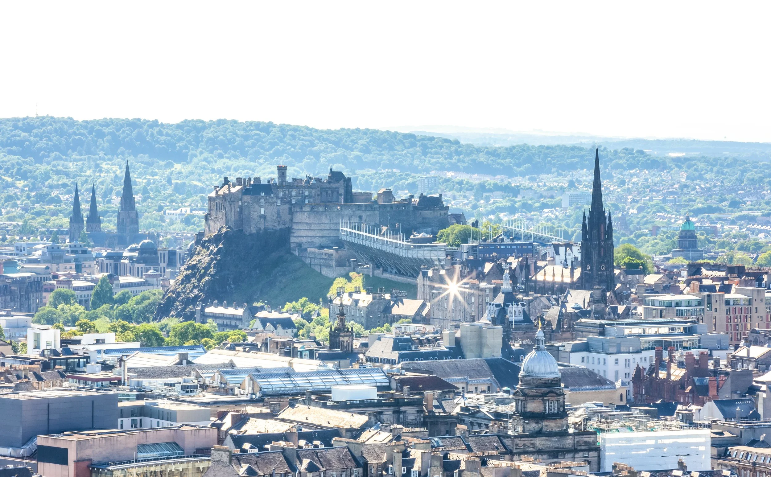
After a tiring two-week long trip to Iceland, we arrived in the Scottish capital of Edinburgh for the second leg of our Europe trip.

As we boarded the airport shuttle bus to the city I could hardly contain my excitement - It would be my first time to visit the country (as an adult) and would include stops in Edinburgh, Glasgow, the Highlands and the Isle of Skye. 

Admittedly I was also excited to be able to take a break from sitting in a car as the previous two weeks spent driving around Iceland were exhausting.

I figured I planned the trip quite well, we’d spend a few days exploring the capital, then we’d board a train to Glasgow and spend a few days there before once again picking up a rental car and driving around the beautiful Loch Lomond into the Highlands and ultimately ending up in the Isle of Skye where we’d spend a week. 

The Isle of Skye, was once one of Scotland’s best kept secrets but has in recent years become one of the country’s top tourist attractions. Every year, especially during the summer months, the island braces itself for the throngs of tourists who come to experience Skye’s breathtaking landscapes, rugged mountains, medieval castles and quaint seaside villages. 

The largest of the Inner Hebrides, a collection of islands just off the coast of the Scottish mainland, Skye has a total land area of 1,656 square kilometres and is home to just over ten thousand people with a population density of about six people per square kilometre. Taking into consideration that here in Taiwan the population density is on average around 650 people per kilometre, it was quite relaxing to drive around a place where there are more sheep than there are people! 

In my excitement to visit Skye, I did lots of research about where to visit, what to do and what to eat while hanging out on the island - One night however while watching Youtube I came across a news story that talked about how tourism was actually having a negative impact on the environment as well as the people who live on the island.

The main problem it seemed was that Skye is small and there aren’t enough hotel rooms available on the island to provide space for the amount of tourists visiting. This has led to many homeowners opening up their spare bedrooms and offering them to tourists on sites like AirBnB and has in turn caused rents and real estate prices on the island to skyrocket forcing many of the young people who grew up on Skye to move elsewhere.

With an estimated 500,000 visitors each year, the tourism industry on Skye has become unsustainable and local authorities are desperate to find solutions for a long-term tourism strategy that will improve the situation for everyone.

The lack of sustainability of the tourism industry and the detrimental effect it is having on Skye has led to several major travel publications, including CNN Travel and the BBC releasing articles that suggest tourists avoid the island altogether. 

Link: Skye islanders call for help with overcrowding after tourism surge (Guardian)

LInk: Tourism experts look to solve overcrowding crisis on Skye (The Scotland Herald) 

Knowing this, the enthusiasm I had for my trip to the island became somewhat subdued but having already booked accommodations at an AirBnB in Portree and renting a car in Glasgow, it was already too late to cancel my plans, which meant that our time on the island would be adding to the issues faced by the people of Skye. 

Being conscious of this, I decided to come up with my own solutions to be a responsible tourist, who would be able to enjoy the island like everyone else, but also contribute to the local economy and ensure that my trip wouldn’t be leaving a negative footprint on the beautiful island.

There are a lot of simple things every visitor can keep in mind to act responsibly while visiting Skye including supporting the local economy, buying local, taking local tours, making use of public transportation, visiting outside of peak times and taking your trash with you. 

Link: How to avoid Isle of Skye Tourism Problems (Wow Scotland) 

The Isle of Skye remains an amazingly beautiful place to visit and if you are thinking about travelling there, you should definitely make the most your opportunity to visit. It is important though that you take into consideration the issues faced by the locals and do your best to ensure that you enjoy the island as a responsible traveller.

Fortunately the time I visited wasn’t during the peak travelling season and I didn’t have to endure the traffic jams which have become quite infamous. It was also quite easy for us to support local businesses by eating at local restaurants and buying fresh local produce at roadside crofts without having to make reservations or stand in line for too long.

In the end, as we drove over the Skye Bridge back to the mainland, I was content with my trip to the island and it was a positive experience that I will always remember. The island is beautiful and the people are wonderful. It is definitely a trip that I would recommend to others but I do hope that the tourism industry on the island can sort itself out and in the meantime that the tourists who visit can practice responsible tourism by not contributing to the destruction of the environment. 

I may at some point dedicate a blog to each of Skye’s major tourist destinations in the same way that I wrote about the Quiraing, but the purpose of this blog post is just to offer up some snapshots that highlight the places I visited and simply provide a brief introduction. I was fortunate to be able to commit a bit more time to the island than most tourists, so you may notice a few locations below that aren’t exactly high on the list of tourist destinations, but are still really cool places to visit nevertheless. 


Old Man of Storr

The “Old Man of Storr” or just “Storr” is a short hike that has become one of the most popular destinations on the island as the so-called “old man”, a rocky crag, has in recent years become an image that symbolizes Scotland.

Situated on a rocky hill on the Trotternish peninsula, this short hike is likely where you’re going to encounter the most tourists on your Isle of Skye trip. The hike, which should take anywhere between an hour or two provides amazing picturesque views of the sea and the lakes below.

If you are visiting the Isle of Skye, this hike is probably going to be on the top of your list of places to visit. 

Unfortunately we had to do the hike on two separate occasions due to extreme changes in the weather on our first visit that turned our visibility from a clear day to almost 0% visibility with crazy amounts of fog rolling in from the sea.

Still, even if you have to do the hike more than once like we did, it is well worth your time and the pictures you’ll take will be one of the highlights of your trip!

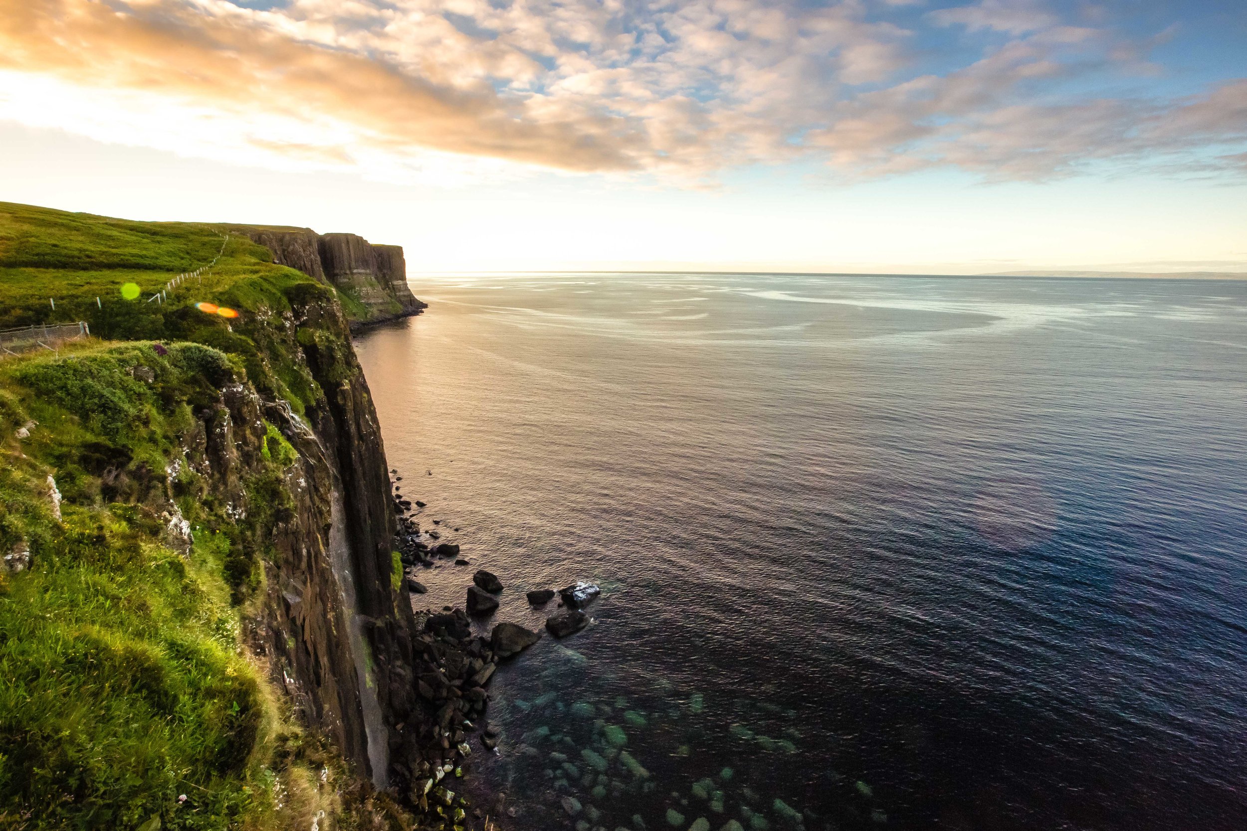
Kilt Rock and Mealt Falls

Kilt Rock is situated along the northern coast of the island on the road between the Old Man of Storr and the Quiraing.

When you stop here you’re rewarded with not only breathtaking ocean landscapes but a waterfall as well. 

From the parking lot, you’ll be guided to a platform where you’re able to view the rocky coastline in addition to Mealt Falls. The rocky cliffs known as “Kilt Rock”, which you view from a distance are said to appear strikingly similar to a Scottish kilt - I don’t have much of an imagination when it comes to rock formations, so I can’t confirm whether or not that’s true. 

Having just come from Iceland, the waterfall wasn’t really that impressive, but the falls, which flow over the cliffs and into the ocean are quite beautiful when combined with the rocky coastline.

Due to the angle of the platform and the cliffs however, its not easy to take photos of the falls but would be an ideal spot if you happened to bring a drone along with you.

One thing about this area I did enjoy however was the beauty of the landscape, which I think was comparable to the Qingshui Cliffs (清水斷崖), one of Taiwan’s most beautiful locations.

Even though I was a bit tired of waterfalls after a couple of weeks in Iceland, my girlfriend decided that after visiting the Quiraing that we’d stop by Kilt Rock for a second time to get nicer photos because we had better light. In the end I was quite happy that we did because the area looked much more beautiful on a day with better weather. 
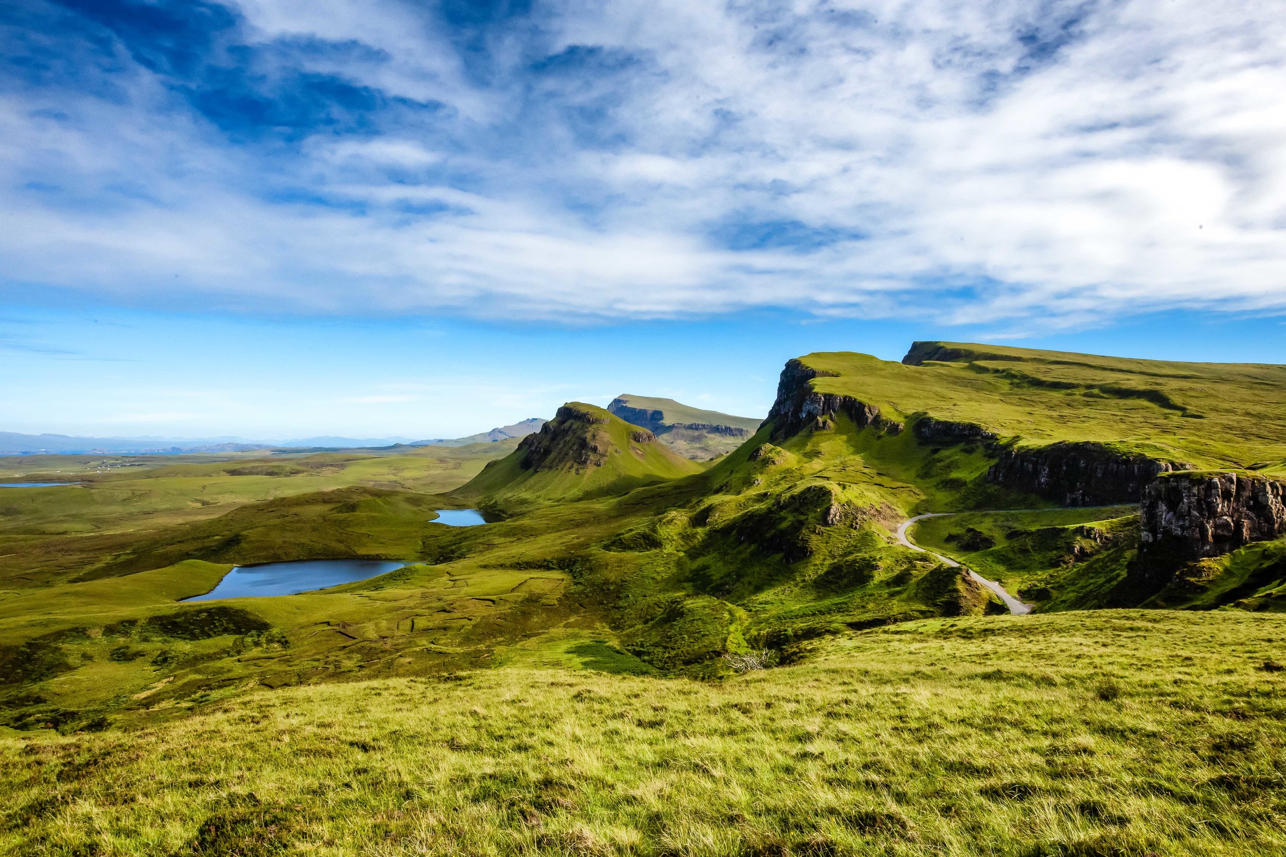
The Quiraing

The Quiraing is arguably the top attraction on the Isle of Skye and is listed as one of the top hikes in all of Scotland - It also just so happens to be one of the more picturesque places in the entire country. 

If you haven’t already, I suggest checking out my dedicated post about the hike. 

Link: The Quiraing

To briefly explain though, the Quiraing is part of the Trotternish ridge, which encapsulates much of the northernmost portion of the Isle of Skye. The geography of the landscape is what makes the Quiraing so special with breathtaking scenery, jagged rock formations and mountainous lakes and valleys. 

The hike is actually quite an easy one, but the length really depends on how much time you’re willing to devote to it. For some, a short hike is enough, but for others, there is an entire circuit that will take you around and across the mountain. 

Whatever you decide you do, you’re sure to have a great time enjoying some of the best scenery this planet has to offer!  

Duntulm Castle

Why not include a little Urban Exploration in your trip to the Isle of Skye? 

Duntulm Castle, a ruined 14th-15th century castle sits quietly on top of a hill overlooking the sea on the north coast of Trotternish. The castle was once the seat of the chiefs of Clan MacDonald of Sleat and was a strategic location in their age-old war against the rival Clan McLeod. 

The castle was abandoned in 1732 with the clan moving to a new residence, Monkstadt House, which used much of Duntulm Castle’s stone for building material. Today the castle sits abandoned and ruined on top of a rocky cliff and is a popular grazing area for local flocks of sheep.

There actually isn’t that much to see when visiting this spot, but it is a great location for taking photos of the coastal landscape with a bunch of ambivalent sheep. We also enjoyed sitting near the beach enjoying the sound of the ocean with the view of the Western Isles in the distance.  
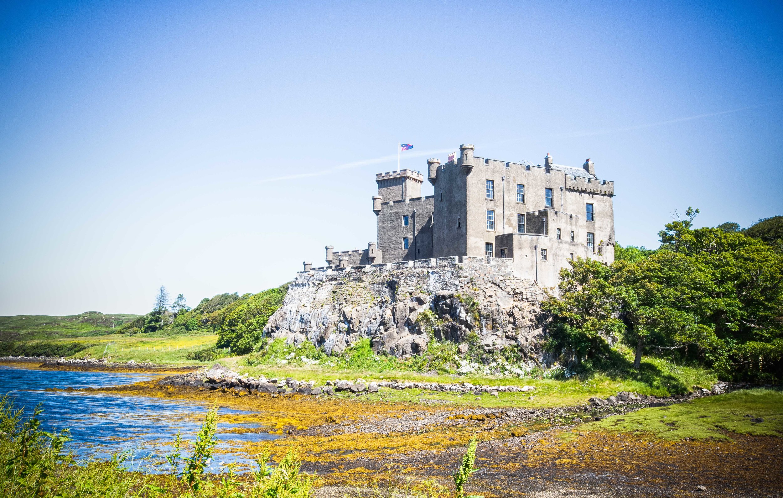
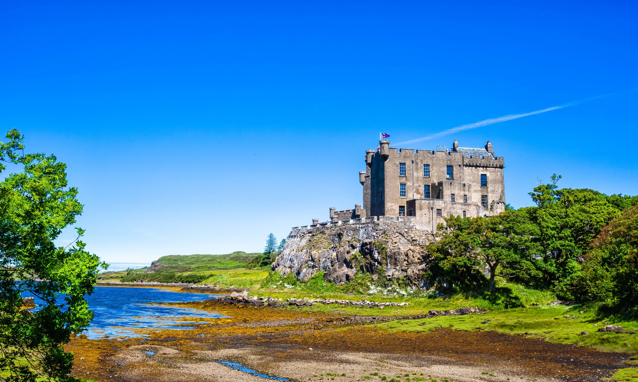
Dunvegan Castle 

Dunvegan Castle and Gardens on the western coast of Skye is the historic home of Clan MacLeod and is one of the most popular tourist attractions on the island. The castle, which is a mixture of medieval and Victorian architecture is the Isle of Skye’s most well preserved castle and is home to many historic relics pertaining to the history of the island. 

The castle is open year round for tourists and the price of admission allows you to explore the interior of the castle as well as the beautifully maintained gardens. 

The interior of the castle was completely refurbished in the 19th Century and is probably not what you’re really expecting. The tour however is interesting and you can learn a lot about the history of the area and the history of the McLeod clan as well. 

The castle’s gardens on the other hand deserve your attention just as much as the castle as the groundskeepers have done an amazing job crafting and maintaining the area, especially with the multitude of plants, trees and flowers that are not native to Scotland’s climate. 
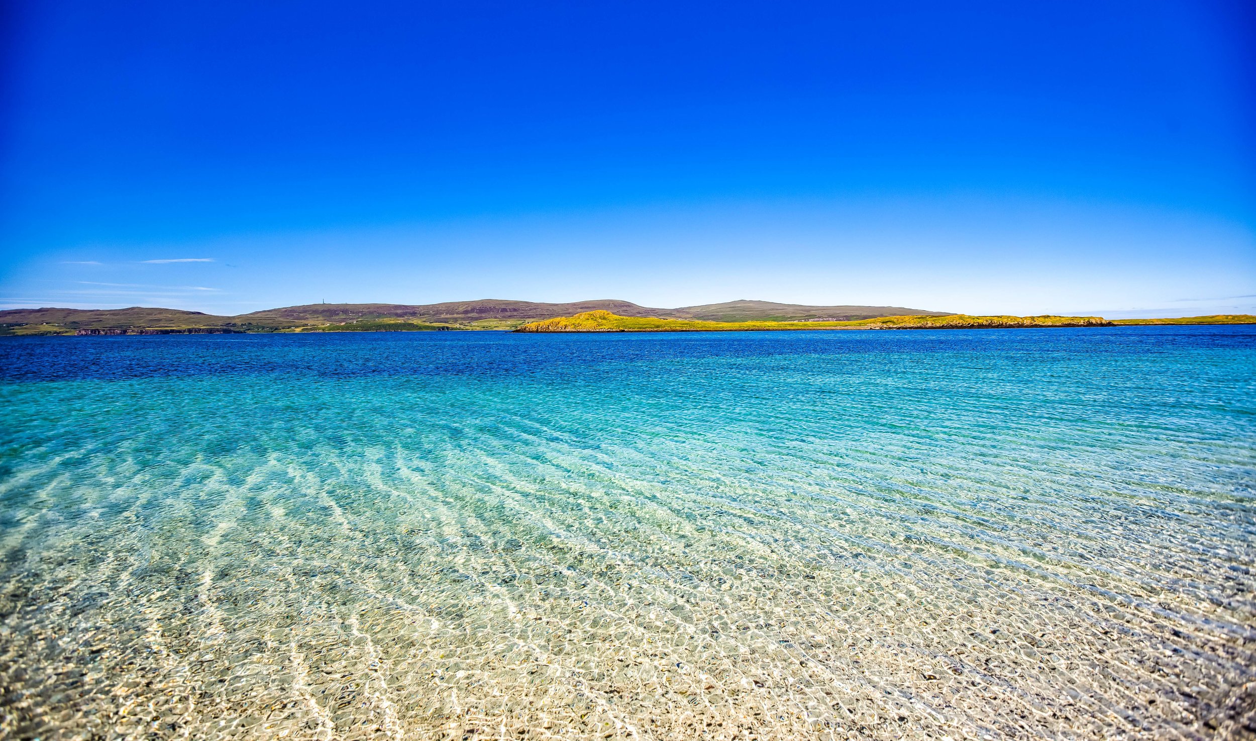
Coral Beach 

You likely weren’t expecting to find a tropical beach as far north as the Isle of Skye, but this coral beach, a short distance away from Dunvegan Castle is probably one of the prettiest beaches in the whole of Scotland. 

From the parking lot, you’ll have to walk for a short distance before arriving at the beach, but the short hike will be well worth your time as the white sand beach made up of broken coral is extremely picturesque, especially with the emerald green water. 

While this isn’t a popular stop for most tourists, the beach is well worth your time, especially since the walk takes you through an extremely quiet and peaceful coastal area. If I had of known how beautiful this place was going to be before going, I would have prepared a romantic picnic for my girlfriend!
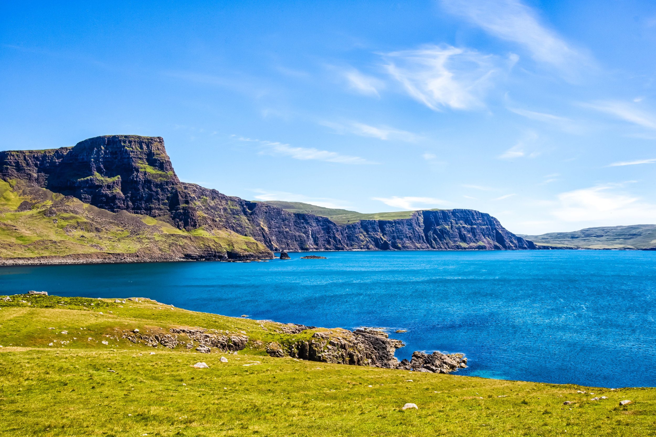
Neist Point

Neist Point is the most westerly area on the Isle of Skye and is home to one of Scotland’s most famous lighthouses, the century-old Neist Point Lighthouse. The point is one of the Isle of Skye’s most famous attractions as it looks out towards the expansive Atlantic Ocean. 

Visiting the area requires a bit of a hike down a steep hill but also rewards visitors with stunning landscapes, coastal scenery and the historic lighthouse. The area is also a popular spot for birdwatching with several species of seabirds making their homes on the cliffs near the lighthouse. If you’re lucky you might also be able to see whales and dolphins feeding in the cove.  

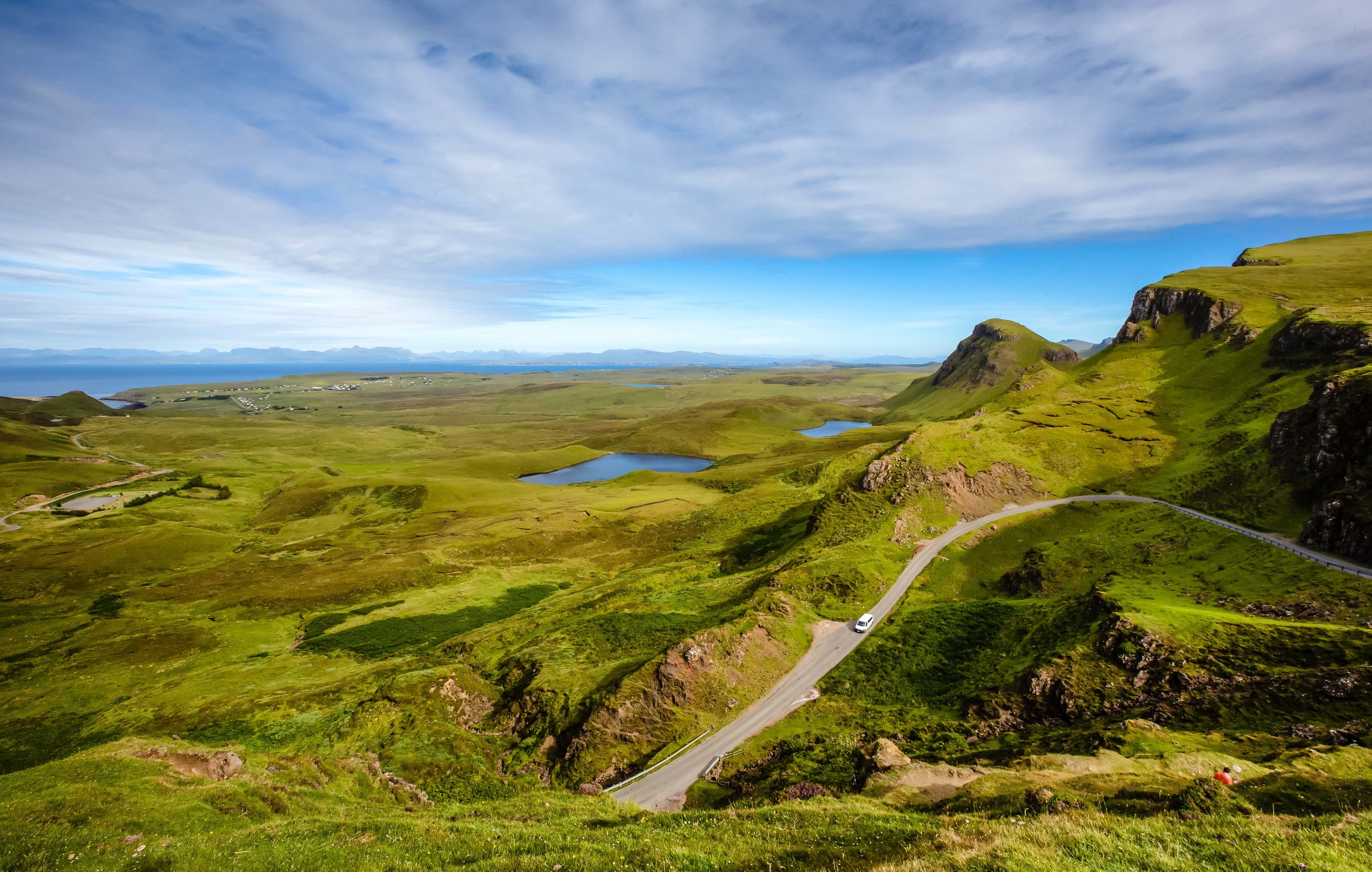
Taking into consideration the popularity of the area, the roads that lead up to it are a major concern and is an area where Skye’s infamous traffic congestion becomes an issue. Not only is there a lack of signage pointing you in the direction of Neist Point, the roads are narrow and are often full of cars on both sides in addition to (what seems like) thousands of grazing sheep. You need to be really careful while driving and make sure that you yield to on-coming traffic.

Once you arrive however the parking lot is quite large, so you don’t need to worry too much about not being able to find a space. The area is also quite large, so you don’t need to worry about a bunch of annoying tourists ruining your photos! 

Dun Beag Broch

Dun Beag Broch is one of the places I listed as a possible location to stop, but to tell the truth I didn’t really know what it was. On our way back to Portree from Neist Point we decided to stop by to check it out and as we approached we got a little more confused. 

Was it a castle? Was it a fort? We had no idea. 

I opened up the dictionary app on my phone and searched the word ‘Broch’ and this is what I found: A circular stone tower built around the beginning of the Christian Era, having an inner and outer wall, found on the Orkney Islands, Shetland Islands, the Hebrides and the mainland of Scotland.

So basically it was an Iron-Age tower-like fort? 

No one knows for certain when the broch was constructed, but what historians do know is that this style of fort became common around 500 BC and it was continuously occupied well into the medieval period and as late as the 19th century. Several excavations have taken place to find out more about it and although exact dates of its origins are still a mystery, archaeologists have discovered coins dating back to the 12th Century.

Today the broch is in ruins but what was once (probably) a ten meter tower with several floors and thick stone walls has been partially excavated to show the passageways of the interior of the building. 

Although there isn’t much to see here, its pretty cool to be able to so freely walk up to a several thousand year old fort where people from the iron-age once lived. 

Eilean Donan Castle 

While not actually located on the Isle of Skye, Eilean Donan Castle, one of Scotland’s most picturesque castles is situated a short distance away from the Skye Bridge and is a must-stop location for anyone making their way to the island. 

The 13th Century castle which literally sits on the ‘Island of Donnán’ was the historic home of the Clan MacKenzie and their allies, the McRae’s. The castle has a long and interesting history and it is said to have been one of the locations that sheltered Robert the Bruce while he was on the run during the early years of his reign as King of Scotland. 

The castle was destroyed in the early eighteenth century due to the MacKenzie’s involvement in the Jacobite rebellions but would be rebuilt between 1919-1932 by a member of Clan McRae who converted it into a memorial for the members of the clan that perished during the First World War.

Fun fact: The memorial is inscribed with the poem “In Flanders Fields” which was penned by John McRae, who would coincidentally become one of the clan’s most well-known figures. 

Today the castle is one of the most photographed places in all of Scotland and has been featured in films ranging from the Highlander to James Bond and has even made an appearance in a Bollywood film! 

As one of Scotland’s most widely photographed locations, it is also a popular tourist attraction with tours of the castle taking place year round for the admission of about £10.00 per guest. If you can afford the hefty price and the long waiting list, you could also hold your wedding at the castle! 


As I’m sure you can see, there is quite a bit to do while travelling around the Isle of Skye - I’ve only really touched on part of what the island has to offer. There’s so much more that you can see and do while on Skye including visits to whisky distilleries, dining at one (or more) of the several Michelin starred restaurants, boat tours, camping, hiking etc. 

You should of course take into consideration the fact that the island has been inundated with tourists, but if you do your part, you can help become part of the solution rather than part of the problem.

If you have the chance to visit, I hope you’re able to enjoy your adventure as much as we did!  


The Quiraing

If you’re an avid hiker, a trip to Scotland won’t disappoint - The country is highly regarded for its rugged mountainous landscapes and it seems that no matter where you are, you’re never far from a breathtaking trail. Even if you’re just hanging out in the capital city of Edinburgh, you can easily hike to the top of a couple of mountains that provide some really great views of the historic cityscape.

Scotland’s mountainous landscapes however are considerably more enjoyable the further you travel north - The sparsely populated Scottish Highlands for example, with boundaries that lie north-west of cities Glasgow, Stirling and Dundee, is an area considered by many to be the cultural heartland of the country and is home to several high mountains, including Ben Nevis, the highest mountain peak in the United Kingdom.

The Highlands are highly regarded for the well-maintained hiking trails, big open skies, whisky distilleries and the amazing people who live there. In fact, tourism figures indicate that over 95% of the foreign tourists who visit Scotland come for the hiking, with well over a million people trekking through the Highlands each year.

With around three-hundred ‘munros’ (mountain peaks) reaching over 3,000 ft, locals in Scotland have taken to referring to these adventurous tourists as ‘Munro Baggers’, which is a shout out to Sir High T Munro, who surveyed and catalogued all of them and started what would be the ultimate Scottish challenge - climbing all of them! 

Link: Scottish Munros and Munro Bagging (Visit Scotland)

If you’ve been considering a trip to Scotland, it’s likely that you’ll have noticed that one of the most common and iconic images of the area isn’t of a peak Ben Nevis or Ben Lomond - they are almost always of the breathtaking landscape of ‘the Quiraing’ on the Isle of Skye.

The Quiraing, which is considered to be Scotland’s premiere mountain hike is one that attracts tourists of all varieties as the experience of hiking the rugged, yet amazingly beautiful trail is one of the best experiences one can have while hiking in Scotland.

Coincidentally it is also the reason why the quiet Isle of Skye has become one of the world’s most popular tourist destinations in recent years.

The Quiraing

The Quiraing, or ‘A' Chuith-Raing’ in Scottish Gaelic is a popular hiking trail along the Isle of Skye’s northernmost Trotternish peninsula. The name ‘Quiraing’ 「KWIR-AN」can be a bit of a tongue-twister for most peoe to pronounce, but don’t worry if you make a mistake, the locals living on the Isle of Skye have heard it all and are happy to indulge you.

The Gaelic name for the ‘Quiraing’ actually originated from the Old Norse words 'Kví Rand' which loosely translates as “Round Fold” referring to the shape of the trail that reaches around the mountain. Historically the trail formed something of a protective barrier which local farmers used to their advantage to conceal their livestock from Viking raiders.

Today you won’t find many cows grazing along the trails, but you are likely to come across quite a few more mountain goats than you will people scattered throughout the trail. Fortunately they’re rather indifferent to your presence and they’re quite well-behaved.

The geologically significant Trotternish Ridge was formed during the glacial age due to a great landslip that occurred in the area. To explain things a bit more scientifically, basically what happened is that gravity forced the much heavier layers of volcanic rock in the area to collapse and dislodge the weaker underlying layers of sedimentary rock forcing a massive landslide.

The landslide, the largest of its kind in the UKs history was responsible for shaping the 19 mile long ridge and created not only the breathtakingly beautiful Quiraing but also the “Old Man of Storr”, another popular tourist destination.

The Quiraing area though stands apart from the rest of the ridge due to the fact that it is the only area that continues to remain geologically active. The landscape is in a constant state of motion and shifts at least a few centimetres each year requiring the roads to have to be repaired on a yearly basis. The result of this constant state of geological motion is breathtaking scenery, jagged rock formations, rolling hills, mountainous lakes and valleys that create a rich tapestry of some of the best landscapes this planet has to offer.

The Hike

So, how do you go about hiking one of Scotlands most iconic trails? Is it going to be difficult? Is it going to take a lot of time? Do you need to be an experienced hiker?

Let me answer those questions quickly: No, No and No.

Once you’ve gotten yourself to the parking lot, what you hike is up to you, how much you’re willing to walk and most importantly, the weather.

The full circuit hike that brings you from the parking lot, all the way around the mountain and back is about 6km in length. Most people however don’t elect to hike that far and instead prefer to walk far enough to get some nice photos and then heading back the way they came.

If you don’t plan on hiking the full loop, you don’t really have to prepare very much other than a camera and your smile. The trail along the mountainside is quite safe and doesn’t require much hiking skill or experience. You can walk as far as you like and then turn around when you think you’ve seen enough.

If on the other hand you plan to do the entire circuit, you’re going to have to prepare some water, snacks, proper footwear and (depending on the season) proper clothing. The full circuit starts out relatively easy, but becomes slightly more difficult once you’re halfway through.

Needless to say, if you’re not a fan of heights, this one probably isn’t for you.

The first portion of the hike follows a well-worn path along the mountain and provides an excellent opportunity for photos of the various crags, lochs and valleys below as well as Rona and Raasay islands in the distance.

the-quiraing-map-1300-7-.jpg

Once you start rounding the cliff, the view starts to change and the level of difficultly starts to increase as well. From this point on, you’re going to be walking mostly up hill with views of the northern coast until you reach the top and start walking down the other side of the mountain to the parking lot.

Even though hiking the full circuit is considered moderately difficult, you’re going to be glad that you made the effort as the upper portion of the mountain affords the most beautiful views of the Quiraing. You’ll also be able to enjoy 360 degree views of the entire northern coast of the Isle of Skye and the Scottish mainland in the distance.

If you hike the entire loop, local estimates indicate that the entire hike should take about two hours to complete - I can assure you though that you’re going to stop on numerous occasions to enjoy the scenery. The number of times you stop in addition to the amount of traffic on the trail are going to be factors in how long it takes you to complete the hike.

So if you really want to enjoy the beauty of the Quiraing, I’d suggest that you prepare for at least 3-4 hours.

I hope that if you’ve read this far, that you’re also able to learn from my failures.

I screwed up when I hiked the Quiraing and I’m a bit ashamed to admit it.

My first failure wasn’t really any fault of my own - The day that I had set aside for hiking the Quiraing fell on a day when the weather was absolutely horrid. We drove up the mountain, parked the car and there was nothing but thick fog, making the trail pretty much impossible to hike (or enjoy).

My second failure was caused by a lack of preparation - I didn’t do enough research into the trails to know how to complete the entire loop. I had assumed that the trail would be well marked and easy route to follow. Unfortunately when we had completed about 75% of the trail, we started feeling like we were lost and were worried that we would lose our light, so we decided to turn around and head back the way we came.

Even though the trails are for the most part well-developed, there aren’t any markers that indicate the direction you should be headed in. Once you round the cliff, the trail starts to become a bit less worn, harder to follow and you’ll come across fewer people. In fact, on the day we were hiking, we were the only people who were hiking the entire circuit, so once we started walking up the cliff face, we were completely alone.

I attempted to consult Google Maps and GPS coordinates while on the trail, but the lack of internet connection in the area became an issue. So, after walking up the cliff face and having no idea how to get back on the trail, we decided to turn around and head back the way we came, which was really unfortunate.

Considering the lack of markers along the trail, you may find yourself in a similar situation, so it is important that you familiarize yourself with the route before you attempt to hike the circuit.

Below is a map of the Quiraing walking route that you can save to your Google Maps.

Link: Stages of the Quiraing Hike (Isle of skye.com)

Getting There


Address: Quiraing, Portree IV51 9LA, Scotland

GPS: (57.6301177, -6.2781544)

Getting to the Quiraing is going to require a bit of effort on your part - Whether you’re travelling directly from Edinburgh, Glasgow or Inverness, you’re going to have to endure the terrible task of driving through several hours of the most scenic roads imaginable.

Sounds tough, right?

The reality of the situation is that if you really want to make the most of your Isle of Skye trip, you’re going to have to rent a car. Even though its possible to take a train and then hopping on a bus that will take you the island, once you’re there you’ll have trouble getting around if you’re relying solely on public transportation.

My Isle of Skye itinerary was an action-packed week of touring the island that would have been impossible to complete without a car, so I can’t stress it enough that if you really want to enjoy the beauty of Skye, you’re going to need your own wheels to get around.

Starting your journey to Skye from Glasgow is probably your best bet as you can easily get there by air or railway. The city is about a 216 mile drive away from the island and offers a multitude of options for car rental services, giving tourists the opportunity to shop around and find the right rental to fit your needs and your budget.

From Glasgow, you’ll make your way around the beautiful Loch Lomond and shortly after you’ll find yourself driving through the Highlands. The drive from there becomes quite simple but you’ll likely want to stop several times to take a break, take some photos or get some food.

One of those stops comes just before you reach the bridge that takes you from the mainland to the Isle of Skye. The picturesque Eileen Donan Castle has become a must visit location for any traveller visiting the area and is a welcome stop after driving through the mountains.

A rare photo of a Josh in the wild.

Once you’ve taken the bridge to Skye, you’ll follow the A87 highway all the way to Portree and then switch to the A855 which will take you up the north-eastern coast of the island. Upon reaching the small village of Staffin you’ll have to start paying attention to signage on the road that will indicate where you’ll make a turn that will bring you up the mountainous road to the Quiraing parking lot.

It is important to note that the road to the Quiraing isn’t the best - Its narrow, its steep, it is often in bad shape and in the peak tourist season, it is jam-packed with traffic. You need to be very careful while driving up and down the road and you’ll also have to be considerate of other drivers making sure that you yield to them allowing them to pass by instead of creating a situation where traffic is stopped completely.

The parking lot is free of charge and is quite large, but during the summer months, it can be quite busy. If you arrive at the parking lot and discover that it is completely full, it is important to remember that you absolutely must not park on the side of the road that takes you up the hill. Not only is it dangerous, it will cause traffic disruptions. 

If you aren’t driving a car, there is an infrequent bus service that will transport you from Portree to Staffin, but once you’ve arrived there you’ll have to walk several kilometres up the road to get to the trailhead. Once you’ve finished hiking, it is likely that you’ll have to wait a long time for a bus that may or may not come. From what I’ve seen, the buses on the island aren’t really to be trusted, so if you do elect to take the public transportation route, you may find yourself stranded, so be sure to have the number of a taxi company handy.

If you prefer to use public transportation, the link below will give you a better idea of what’s available and how to better plan your trip.

Link: Travel Tips (Isle of skye.com)

In recent years the Isle of Skye has been overrun by tourists - so much that the local infrastructure has been stretched to its limits and most landowners are becoming AirBnBs hosts or converting their property into private lodges. This has had an adverse effect on the local economy with many local residents of Skye unable to purchase their own homes or finding a place to stay.

While there are arguments with regard to the sustainability of the tourism industry on the island, it is important to remember when planning your trip that travelling to the Isle of Skye is not going to be cheap due to demand and a lack of places to stay.

The reward though, for those willing to travel the long distance to the island and pay the high prices for room and board is spectacular scenery and memories that will last a lifetime.

If you travel to Skye, this trail is likely going to be your number one destination, so I don’t need to tell you how much I recommend visiting. Make sure though that you take some time to hike the full circuit and enjoy the spectacular scenery. You won’t regret it.


Fort San Domingo (紅毛城)


A few months ago I was commissioned to take photos for an article, a sample forty-eight hour itinerary for people visiting Taipei for the Indonesian travel magazine, DestinAsian.

I couldn’t imagine only having two full days in Taipei - After more than a decade, I’m still finding new places and enjoying new experiences. It goes without saying that the article covered quite a few of the places I’ve already been to, but strangely there were a couple that were still new to me.

You might think its weird that an article describing places that people should see during a forty-eight hour trip to Taiwan actually took me, a travel photographer, over a decade to visit.

All I can say is, maybe I just don’t really have a thing for old forts.

I hail from Nova Scotia on the East Coast of Canada and grew up seeing forts all over the place - English forts, French forts, my neighbours snow forts, etc.

They just don’t really excite me very much.

Still, when you’re getting paid to take photos, you can’t really pick and choose what the client wants, so on an early morning, I made my way out to Tamsui to take photos of one of the area’s most important tourist destinations, the historic Fort San Domingo.

Geographically speaking, Tamsui (or Danshui) is actually a lot closer to where I live than Taipei is, but if you’re not driving a scooter or a car, its a bit of a pain in the ass to get there. If I drove a car, it would have taken about half an hour but with a bus to Taipei and then the long MRT ride, it ended up taking almost two hours.

Given the amount of time it takes to get out there, every time I’ve visited I’ve more or less stuck to the popular areas around the Old Street and the riverside. It’s also a bit embarrassing to admit that I was always under the impression that the fort was quite a distance away from the downtown area which prevented me from visiting.

Suffice to say, I found out that it is actually within walking distance from the MRT station.

Now that I’ve visited Fort San Domingo, I can honestly say that I regret not visiting sooner.

Not only should this spot be on the itinerary of every tourists visit to Tamsui, it is one of the few historic spots in Northern Taiwan that deals with Taiwan’s Western Colonial history.

History

With a history dating back to 1624, Fort San Domingo, both a fortress and consulate, has been one of the most significant locations (with regard to western trade) in Taiwan for almost four centuries. Over its long history it has been controlled by the Spanish Conquistadors, the Dutch, the Qing, the Japanese and the British before becoming a National Historic Site in the modern era.

With such a long list of owners, the fort also had a variety of names - Today we refer to it by its original name “Fort San Domingo” (聖多明哥城) but it has also been referred to as Fort Antonio (安東尼堡), Koumoujyo (こうもうじょう) and colloquially by the locals as Âng-mn̂g-siânn (紅毛城), which in Taiwanese Hokkien translates as the “Red Hair Fort”, a clever way of describing the ‘weird-looking’ Dutch people who came to Taiwan.

Coincidentally if you visit the fort today, it appears red in colour, painted that way to match the consulate residence next door, although I’d like to think that it was an ironic way of paying homage to the nickname the locals gave it.

Spanish Era

The history of a fort located in this area started with the construction of the original Fort San Domingo around 1628-1629. The Spanish, who had already established a colony on what is today’s “Heping Island” (和平島) in Keelung, sought to increase their land holdings and expanded by force into the Tamsui area which was already a popular trading outpost with Chinese merchants.

The original Fort San Domingo was constructed simply of clay, wood and bamboo polls but didn’t last very long. A few years after it was constructed, it was attacked and demolished by a group of angry locals who were irritated with the taxes levied on them by the Spanish governor.

In 1637, a year after the fort was demolished, it was rebuilt, but this time they instead used stone and raised the walls to over twenty feet making life for the over one hundred soldiers stationed inside much safer from attacks by local militias.

The locals unfortunately turned out to be the least of their concerns because in 1641 the Dutch started to show more interest in the region and weren’t really big fans of the Spanish hanging around.

After a couple of attempts (over a period of two years), the Dutch were able to kick the Spanish out of Taiwan. Before they did though, the Spanish demolished the fort out of spite, because they weren’t interested in sharing it.

Dutch Era

As mentioned above, the Dutch East India Company (荷蘭東印度工色) started to take an interest in the area in the mid-1600s with plans to expand their trade with the locals. First though they had to expel the Spanish from Tamsui and Keelung to ensure their monopoly on trade and the safety of their trade ships.

In 1642 the Dutch sailed into Tamsui harbour with a large naval and land force and laid siege on the fort for a period of three weeks. They then moved on to and eventually took the port at Keelung ending the short lived Spanish occupation of Taiwan.

Once the Dutch kicked the Spanish out of the area they moved quickly to secure their position constructing a new fort on the site of the original that laid in ruins. The new fort, named Fort Antonio (安東尼堡), constructed in 1644 is the historic site that you can still see today.

With 32 foot high walls made of brick and stone was home to over 80 soldiers who were stationed there to protect the area and ensure that the trade of deer skins and sulphur went smoothly.

A few decades later, In 1661, a naval fleet of over 200 ships, led by Koxinga (鄭成功) landed in southern Taiwan with the intention of expelling the Dutch and establishing a base of operations on the island. After a nine-month siege the Dutch were defeated and signed articles of surrender at their southern stronghold at Fort Zeelandia (熱蘭遮城).

Undeterred, they quickly signed a cooperation agreement with the newly established Qing empire in China and reestablished their Taiwan base of operations in Keelung and Tamsui.

Their stay however was short lived as they were unable to retake any of their former holdings in central Taiwan and revolts by the Basai Indigenous peoples (巴賽族) saw many of their properties burnt to the ground.

Under constant threat from the locals and being caught in the war between Koxinga and the Qing in the south, the situation became untenable and Dutch decided to abandon the fort and left Taiwan in 1668.

Qing Dynasty

From 1683 - 1867 the fort controlled by Qing government representatives stationed in Taiwan.

The Qing never actually took up residence in the fort but they constructed stone walls with four gates around the perimeter in order to fortify their position in case of attack.

During the reign of the Jiaqing Emperor (嘉慶帝), China got involved in several incursions with the French over territory in Vietnam. In response the French sailed to Taiwan and attacked in Tamsui and Keelung. Easily defeated, they soon realized that their coastal defense network in Taiwan was more or less useless so in the following years they constructed several fortifications in key economic hot spots to protect their interests.

None of that would really matter though because in 1860s, as a result of the Second Opium War (第二次鴉片戰爭), the Qing were forced to sign the Treaty of Tianjin (天津條約) ceding Hong Kong to the British as well as Fort San Domingo (among many other properties) which would be used as a trade consulate.

When the British moved in, the fort was in bad shape with moss and other stuff growing on the walls, so they decided to clean it up and paint the fort red. Later they constructed the beautiful residence next to the fort to serve as a consular residence.

Notably, British linguist Herbert Allan Giles, known for his creation of a romanized system for Mandarin, lived in the fort or a period of three years while conducting research on what would become the Wade-Giles system of romanization (威妥瑪拼音), which is still widely used in Taiwan today.

Japanese Colonial Era

When Japan took control of Taiwan in 1895, things pretty much stayed the same at the British Consulate. The office continued to conduct its affairs and thanks to the colonial governments development projects, was able to modernize the property with running water, a sewage system and electricity.

In 1930, the Japanese government listed the site as a National Historic Monument (史蹟名勝天然紀念物保存法) and conducted surveys of the site to ensure its preservation.

Modern Era

When the Second World War came to an end, the Japanese were forced to surrender control of Taiwan to Chiang Kai-Shek and the Republic of China. The British returned to Taiwan and re-opened the consulate in 1946 and even though diplomatic relations between the ROC and the UK broke off a few years later, the consulate remained open to maintain economic ties.

In 1972, the British moved out of the consulate and tried to sell the land to the local government which wanted to turn the fort into a public museum. The asking price for the land however was far too high and the government refused to pay. Instead of selling the fort, the British placed the it under the stewardship of the United States which would maintain the grounds.

When America established relations with the People’s Republic of China in 1979, they were forced to cut formal diplomatic relations with Taipei, which once again made the question of the ownership of the fort an issue. The British didn’t have much interest in continuing to argue with the government, so in 1980 they turned over ownership of the fort, which was then listed as a National Historic Site and plans were made to open it up to the public.

In 1984, after a period of restoration, the fort was opened and amazingly attracted more then 40,000 visitors on its first day of operation.

Ownership and operation of the fort was later transferred to Taipei County (Currently New Taipei City) in 2002, which came up with plans to renovate the park after years of tourism put considerable wear and tear on the grounds.

After being closed for a year the fort reopened again to the public in 2005 as part of the Tamsui Historical Museum (淡水古蹟博物館), a network of historic sites in the area that has a modest admission fee and provides access to each of the sites.

Design

The area that encompasses ‘Fort San Domingo’ consists primarily of two main buildings which include the fort and the former consular residence. The area however is set up a bit like a park with a nature area on the hill below the main buildings with some additional buildings setup that help tourists learn about the area and provides shaded rest stops for visitors to have some food or drinks.

Strangely though, the actual fort is often a bit of an afterthought for most tourists as they prefer to spend most of their time touring and taking photos of the beautiful Victorian-style mansion instead. And you know what, I can’t really blame them. As far as architecture goes, the consular residence is absolutely beautiful and is a rare sight in Taiwan - The fort on the other hand isn’t really that appealing to the eye.

Fort San Domingo (主堡)

The information you’ll received on site claims that Fort San Domingo is the oldest surviving historic building in Taiwan. I’m not sure how much I believe that, but I guess I’ll give them the benefit of the doubt on this one, because yeah, it is pretty old.

The fort, which was constructed on the top of a hill overlooks the mouth of the Tamsui River and was constructed in a strategic location allowing the people in the tower to have the ability to closely watch who was coming and going through the river.

The fort is square-shaped and is about 15 meters in length and 13 meters in height. The walls around the fort are about two meters thick and were constructed with the thought that they could withstand artillery attacks.

The two-storey fort used a mixture of stones and brick to strengthen the walls of the structure. The outside walls, which were originally painted white were painted with stucco and lacquer but was later repainted red by the British to match with the colour of the consular residence.

The interior of the fort consists of a few rooms, which used to house soldiers and later consular officials. There’s not much to see inside, but the people who run the site have added some exhibitions that let you learn about what life was like when the fort was once a military outpost.

Consular Residence (領事官邸)

The beautiful Victorian-style Consular Residence is where most tourists focus their attention while visiting the area. The large two-storey brick building, constructed in 1891 is considered to be indicative of British colonial style architecture but mixes in a bit of local construction techniques that help to shelter the building from wind and rain.

The exterior of the red brick building is beautifully designed with arches along the veranda that encircles the perimeter of the building and makes for some beautiful photos.

The interior consists of several rooms on the first floor that were used for consular affairs including offices, a large foyer, meeting room and dining room, etc. The second floor likewise consists of three large bedrooms and storage rooms that housed the consular officials and their families. The rooms are large and beautiful and are currently full of displays that educate guests on what life in the residence was like.

The residence was designed by a British architect, but the craftsmen who constructed the building as well as the bricks and other material used in its construction were all imported from Xiamen in China. Likewise, the fireplace and clocks in the building were also imported, but directly from England.

Unlike the fort, most of the rooms in the residence are open the public and there are informative displays in each of them that allow visitors to learn about the house.

If you’ve got time, I recommend checking out each of the rooms, then walking around the perimeter of the building and checking out the line of cannons that sit to the rear of the building in the area between the fort and the consular residence.

For a more detailed description of the design of the consular residence check this link: Tamsui Historical Museum - The British Consular Residence.

Getting There


Fort San Domingo is located a short distance from the main stretch of the Tamsui Old Street. If you are planning a day-trip to the area, I recommend first walking from the Tamsui MRT Station (淡水捷運站) to the fort, checking it out and then making your way back to the MRT station walking along the riverside. This way you’ll get to walk the entire loop and not miss anything.

There are of course a few places you could stop along the way including the historic Fuyou Temple (福佑宮), Tamsui Church (淡水禮拜堂), the Tamsui Red Castle (淡水紅樓) and the Tamsui Customs Officers’ Residence (小白宮) among others.

If you follow this route, you can easily leave the MRT station and walk straight down Zhongzheng Road (中正路) until you reach the fort - even visiting a few places along the way. Then when you’re finished you can explore the Old Street along the riverside on the way back.

For those who have their own itinerary in mind, the address for the fort is:

No. 1, Lane 28, Zhongzheng Road. Tamsui District, New Taipei City. (新北市淡水區中正路28巷1號)

If you prefer to save some time and take a bus to the fort, you can take either bus #836 or Red 26 directly from the Tamsui MRT Station bus terminal.

You should also note that Fort San Domingo is open on weekdays from 9:30-5:00 and from 9:30-6:00 on weekends. It is closed only on the first Monday of every month.

There is also a modest admission fee of $80NT that offers visitors access to Fort San Domingo as well as nearby Hobe Fort (滬尾礮臺) and the Tamsui Custom Officer’s Residence (小白宮).

You have the option of paying with cash or your EasyCard (悠遊卡).

After living in Taiwan for so long, it is hard to believe that it took an article about a 48 hour trip in Taipei to get me to this historic tourist destination. In retrospect that is something I regret, I should have visited much sooner. If you’re travelling in the Tamsui area, you should definitely take the time to visit as well.