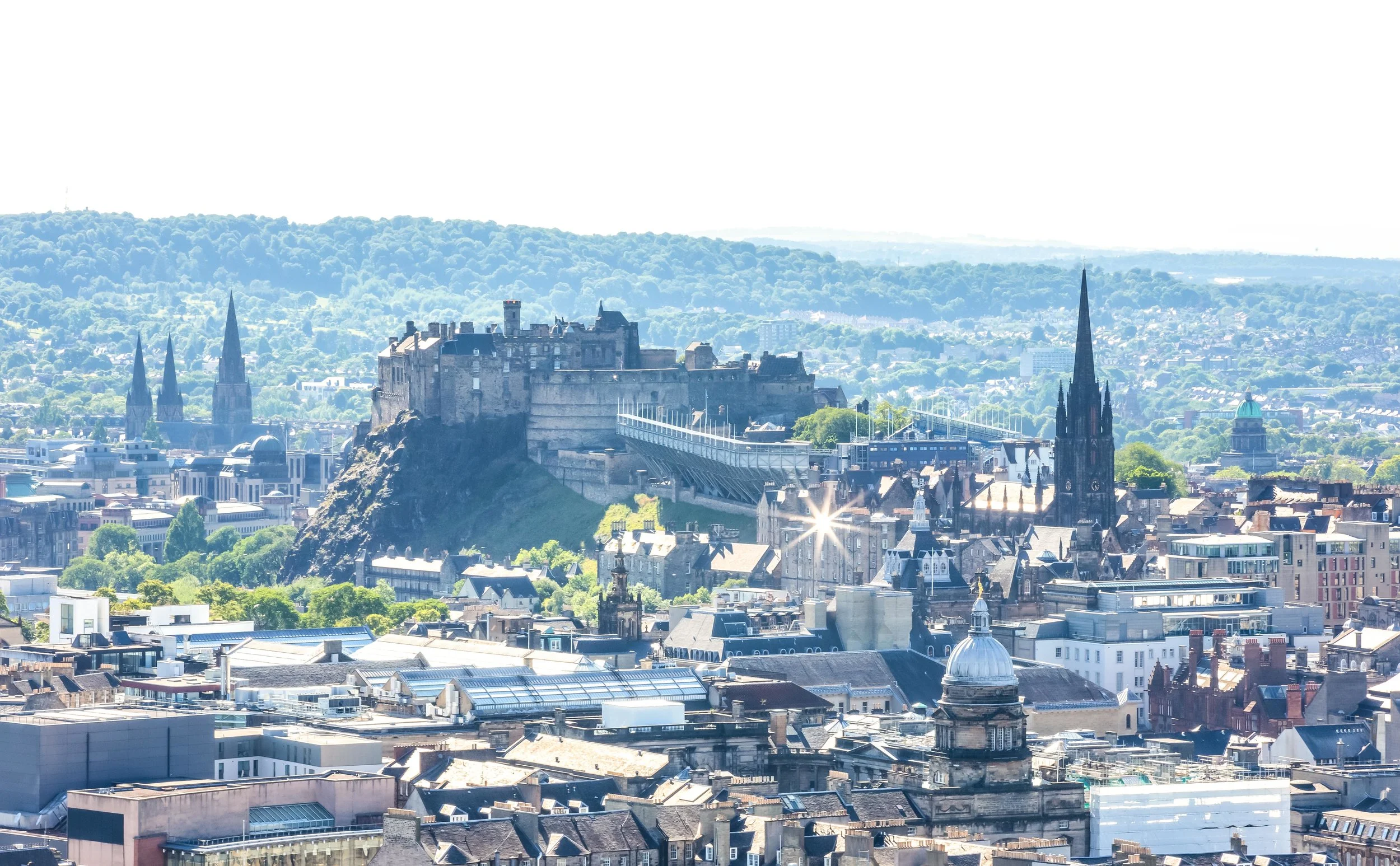
If you’re an avid hiker, a trip to Scotland won’t disappoint - The country is highly regarded for its rugged mountainous landscapes and it seems that no matter where you are, you’re never far from a breathtaking trail. Even if you’re just hanging out in the capital city of Edinburgh, you can easily hike to the top of a couple of mountains that provide some really great views of the historic cityscape.
Scotland’s mountainous landscapes however are considerably more enjoyable the further you travel north - The sparsely populated Scottish Highlands for example, with boundaries that lie north-west of cities Glasgow, Stirling and Dundee, is an area considered by many to be the cultural heartland of the country and is home to several high mountains, including Ben Nevis, the highest mountain peak in the United Kingdom.
The Highlands are highly regarded for the well-maintained hiking trails, big open skies, whisky distilleries and the amazing people who live there. In fact, tourism figures indicate that over 95% of the foreign tourists who visit Scotland come for the hiking, with well over a million people trekking through the Highlands each year.
With around three-hundred ‘munros’ (mountain peaks) reaching over 3,000 ft, locals in Scotland have taken to referring to these adventurous tourists as ‘Munro Baggers’, which is a shout out to Sir High T Munro, who surveyed and catalogued all of them and started what would be the ultimate Scottish challenge - climbing all of them!
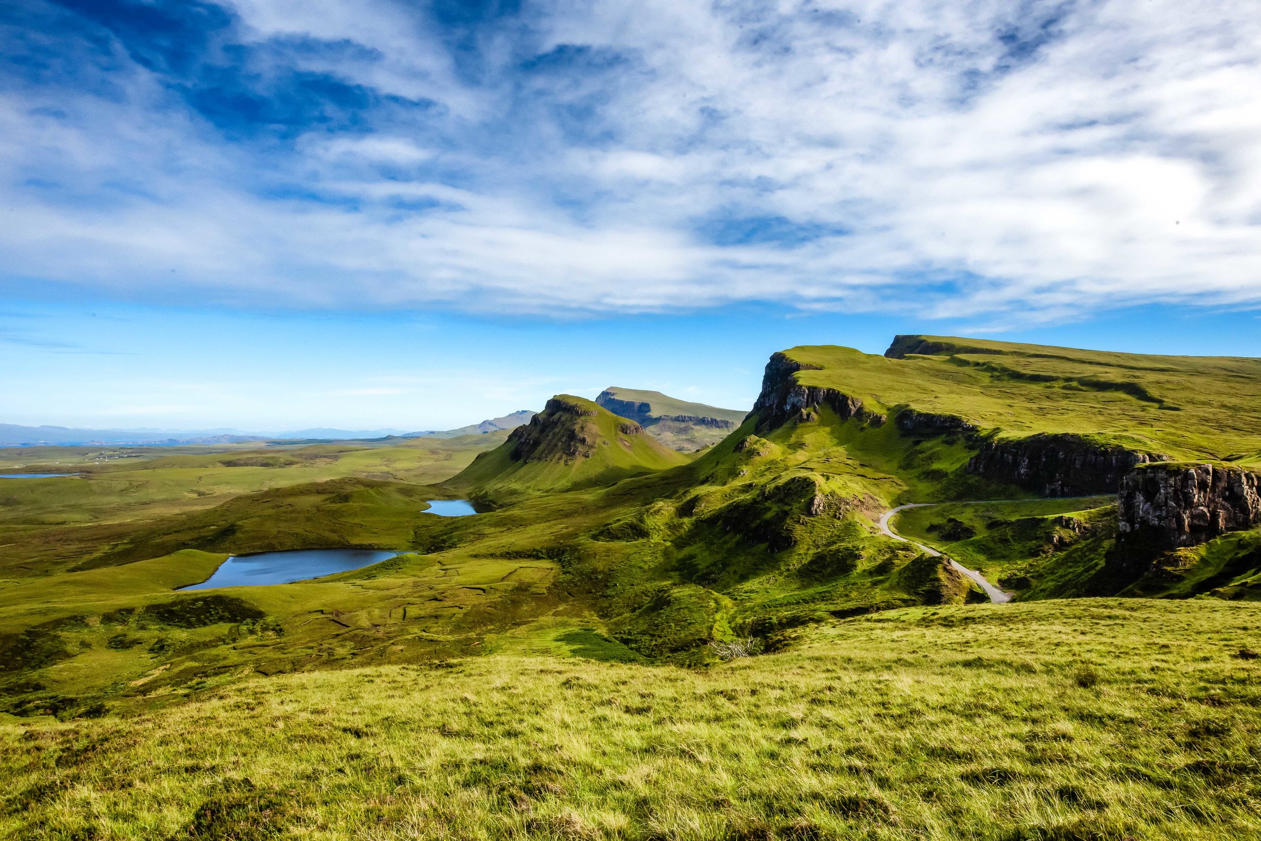
If you’ve been considering a trip to Scotland, it’s likely that you’ll have noticed that one of the most common and iconic images of the area isn’t of a peak Ben Nevis or Ben Lomond - they are almost always of the breathtaking landscape of ‘the Quiraing’ on the Isle of Skye.
The Quiraing, which is considered to be Scotland’s premiere mountain hike is one that attracts tourists of all varieties as the experience of hiking the rugged, yet amazingly beautiful trail is one of the best experiences one can have while hiking in Scotland.
Coincidentally it is also the reason why the quiet Isle of Skye has become one of the world’s most popular tourist destinations in recent years.
The Quiraing
The Quiraing, or ‘A' Chuith-Raing’ in Scottish Gaelic is a popular hiking trail along the Isle of Skye’s northernmost Trotternish peninsula. The name ‘Quiraing’ 「KWIR-AN」can be a bit of a tongue-twister for most peoe to pronounce, but don’t worry if you make a mistake, the locals living on the Isle of Skye have heard it all and are happy to indulge you.
The Gaelic name for the ‘Quiraing’ actually originated from the Old Norse words 'Kví Rand' which loosely translates as “Round Fold” referring to the shape of the trail that reaches around the mountain. Historically the trail formed something of a protective barrier which local farmers used to their advantage to conceal their livestock from Viking raiders.
Today you won’t find many cows grazing along the trails, but you are likely to come across quite a few more mountain goats than you will people scattered throughout the trail. Fortunately they’re rather indifferent to your presence and they’re quite well-behaved.
The geologically significant Trotternish Ridge was formed during the glacial age due to a great landslip that occurred in the area. To explain things a bit more scientifically, basically what happened is that gravity forced the much heavier layers of volcanic rock in the area to collapse and dislodge the weaker underlying layers of sedimentary rock forcing a massive landslide.
The landslide, the largest of its kind in the UKs history was responsible for shaping the 19 mile long ridge and created not only the breathtakingly beautiful Quiraing but also the “Old Man of Storr”, another popular tourist destination.
The Quiraing area though stands apart from the rest of the ridge due to the fact that it is the only area that continues to remain geologically active. The landscape is in a constant state of motion and shifts at least a few centimetres each year requiring the roads to have to be repaired on a yearly basis. The result of this constant state of geological motion is breathtaking scenery, jagged rock formations, rolling hills, mountainous lakes and valleys that create a rich tapestry of some of the best landscapes this planet has to offer.


The Hike
So, how do you go about hiking one of Scotlands most iconic trails? Is it going to be difficult? Is it going to take a lot of time? Do you need to be an experienced hiker?
Let me answer those questions quickly: No, No and No.
Once you’ve gotten yourself to the parking lot, what you hike is up to you, how much you’re willing to walk and most importantly, the weather.
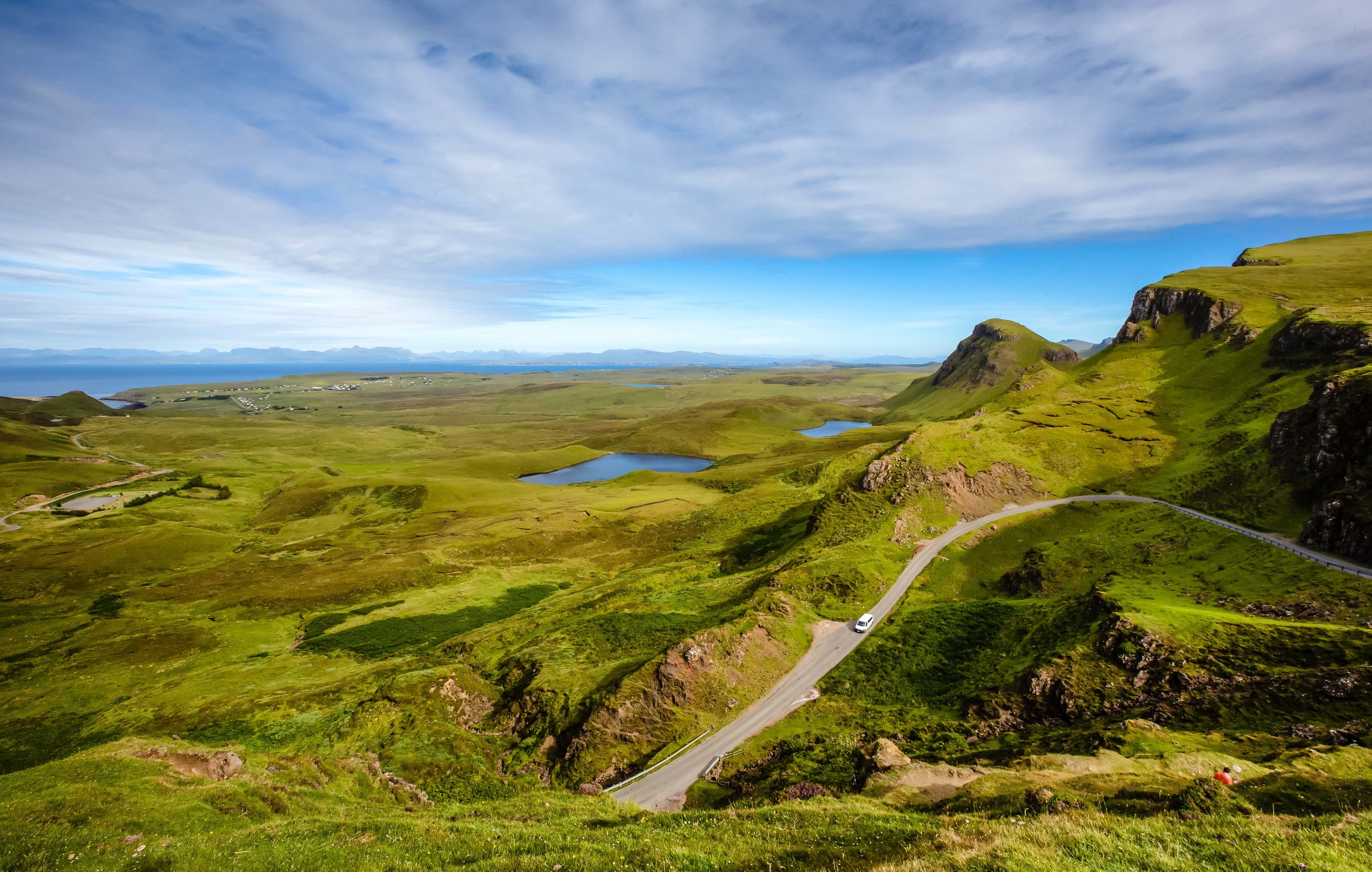
The full circuit hike that brings you from the parking lot, all the way around the mountain and back is about 6km in length. Most people however don’t elect to hike that far and instead prefer to walk far enough to get some nice photos and then heading back the way they came.
If you don’t plan on hiking the full loop, you don’t really have to prepare very much other than a camera and your smile. The trail along the mountainside is quite safe and doesn’t require much hiking skill or experience. You can walk as far as you like and then turn around when you think you’ve seen enough.
If on the other hand you plan to do the entire circuit, you’re going to have to prepare some water, snacks, proper footwear and (depending on the season) proper clothing. The full circuit starts out relatively easy, but becomes slightly more difficult once you’re halfway through.
Needless to say, if you’re not a fan of heights, this one probably isn’t for you.
The first portion of the hike follows a well-worn path along the mountain and provides an excellent opportunity for photos of the various crags, lochs and valleys below as well as Rona and Raasay islands in the distance.

Once you start rounding the cliff, the view starts to change and the level of difficultly starts to increase as well. From this point on, you’re going to be walking mostly up hill with views of the northern coast until you reach the top and start walking down the other side of the mountain to the parking lot.
Even though hiking the full circuit is considered moderately difficult, you’re going to be glad that you made the effort as the upper portion of the mountain affords the most beautiful views of the Quiraing. You’ll also be able to enjoy 360 degree views of the entire northern coast of the Isle of Skye and the Scottish mainland in the distance.
If you hike the entire loop, local estimates indicate that the entire hike should take about two hours to complete - I can assure you though that you’re going to stop on numerous occasions to enjoy the scenery. The number of times you stop in addition to the amount of traffic on the trail are going to be factors in how long it takes you to complete the hike.
So if you really want to enjoy the beauty of the Quiraing, I’d suggest that you prepare for at least 3-4 hours.
I hope that if you’ve read this far, that you’re also able to learn from my failures.
I screwed up when I hiked the Quiraing and I’m a bit ashamed to admit it.
My first failure wasn’t really any fault of my own - The day that I had set aside for hiking the Quiraing fell on a day when the weather was absolutely horrid. We drove up the mountain, parked the car and there was nothing but thick fog, making the trail pretty much impossible to hike (or enjoy).
My second failure was caused by a lack of preparation - I didn’t do enough research into the trails to know how to complete the entire loop. I had assumed that the trail would be well marked and easy route to follow. Unfortunately when we had completed about 75% of the trail, we started feeling like we were lost and were worried that we would lose our light, so we decided to turn around and head back the way we came.
Even though the trails are for the most part well-developed, there aren’t any markers that indicate the direction you should be headed in. Once you round the cliff, the trail starts to become a bit less worn, harder to follow and you’ll come across fewer people. In fact, on the day we were hiking, we were the only people who were hiking the entire circuit, so once we started walking up the cliff face, we were completely alone.
I attempted to consult Google Maps and GPS coordinates while on the trail, but the lack of internet connection in the area became an issue. So, after walking up the cliff face and having no idea how to get back on the trail, we decided to turn around and head back the way we came, which was really unfortunate.
Considering the lack of markers along the trail, you may find yourself in a similar situation, so it is important that you familiarize yourself with the route before you attempt to hike the circuit.
Below is a map of the Quiraing walking route that you can save to your Google Maps.


Getting There
Address: Quiraing, Portree IV51 9LA, Scotland
GPS: (57.6301177, -6.2781544)
Getting to the Quiraing is going to require a bit of effort on your part - Whether you’re travelling directly from Edinburgh, Glasgow or Inverness, you’re going to have to endure the terrible task of driving through several hours of the most scenic roads imaginable.
Sounds tough, right?
The reality of the situation is that if you really want to make the most of your Isle of Skye trip, you’re going to have to rent a car. Even though its possible to take a train and then hopping on a bus that will take you the island, once you’re there you’ll have trouble getting around if you’re relying solely on public transportation.
My Isle of Skye itinerary was an action-packed week of touring the island that would have been impossible to complete without a car, so I can’t stress it enough that if you really want to enjoy the beauty of Skye, you’re going to need your own wheels to get around.
Starting your journey to Skye from Glasgow is probably your best bet as you can easily get there by air or railway. The city is about a 216 mile drive away from the island and offers a multitude of options for car rental services, giving tourists the opportunity to shop around and find the right rental to fit your needs and your budget.
From Glasgow, you’ll make your way around the beautiful Loch Lomond and shortly after you’ll find yourself driving through the Highlands. The drive from there becomes quite simple but you’ll likely want to stop several times to take a break, take some photos or get some food.
One of those stops comes just before you reach the bridge that takes you from the mainland to the Isle of Skye. The picturesque Eileen Donan Castle has become a must visit location for any traveller visiting the area and is a welcome stop after driving through the mountains.
Once you’ve taken the bridge to Skye, you’ll follow the A87 highway all the way to Portree and then switch to the A855 which will take you up the north-eastern coast of the island. Upon reaching the small village of Staffin you’ll have to start paying attention to signage on the road that will indicate where you’ll make a turn that will bring you up the mountainous road to the Quiraing parking lot.
It is important to note that the road to the Quiraing isn’t the best - Its narrow, its steep, it is often in bad shape and in the peak tourist season, it is jam-packed with traffic. You need to be very careful while driving up and down the road and you’ll also have to be considerate of other drivers making sure that you yield to them allowing them to pass by instead of creating a situation where traffic is stopped completely.
The parking lot is free of charge and is quite large, but during the summer months, it can be quite busy. If you arrive at the parking lot and discover that it is completely full, it is important to remember that you absolutely must not park on the side of the road that takes you up the hill. Not only is it dangerous, it will cause traffic disruptions.
If you aren’t driving a car, there is an infrequent bus service that will transport you from Portree to Staffin, but once you’ve arrived there you’ll have to walk several kilometres up the road to get to the trailhead. Once you’ve finished hiking, it is likely that you’ll have to wait a long time for a bus that may or may not come. From what I’ve seen, the buses on the island aren’t really to be trusted, so if you do elect to take the public transportation route, you may find yourself stranded, so be sure to have the number of a taxi company handy.
If you prefer to use public transportation, the link below will give you a better idea of what’s available and how to better plan your trip.
In recent years the Isle of Skye has been overrun by tourists - so much that the local infrastructure has been stretched to its limits and most landowners are becoming AirBnBs hosts or converting their property into private lodges. This has had an adverse effect on the local economy with many local residents of Skye unable to purchase their own homes or finding a place to stay.
While there are arguments with regard to the sustainability of the tourism industry on the island, it is important to remember when planning your trip that travelling to the Isle of Skye is not going to be cheap due to demand and a lack of places to stay.
The reward though, for those willing to travel the long distance to the island and pay the high prices for room and board is spectacular scenery and memories that will last a lifetime.
If you travel to Skye, this trail is likely going to be your number one destination, so I don’t need to tell you how much I recommend visiting. Make sure though that you take some time to hike the full circuit and enjoy the spectacular scenery. You won’t regret it.