Travel

Sun Moon Lake (日月潭)

For most North Americans who come to Taiwan it can be a bit of a strange feeling seeing how excited Taiwanese people get when they talk about how large and beautiful their 7.93 km² Sun Moon Lake (日月潭) is even when the smallest of our Great Lakes, Lake Ontario is 18,960 km² in comparison. 

That being said, everything is relative. The Great Lakes are polluted and are frozen nine months of the year, and as all arguments like this go: Size isn't Everything

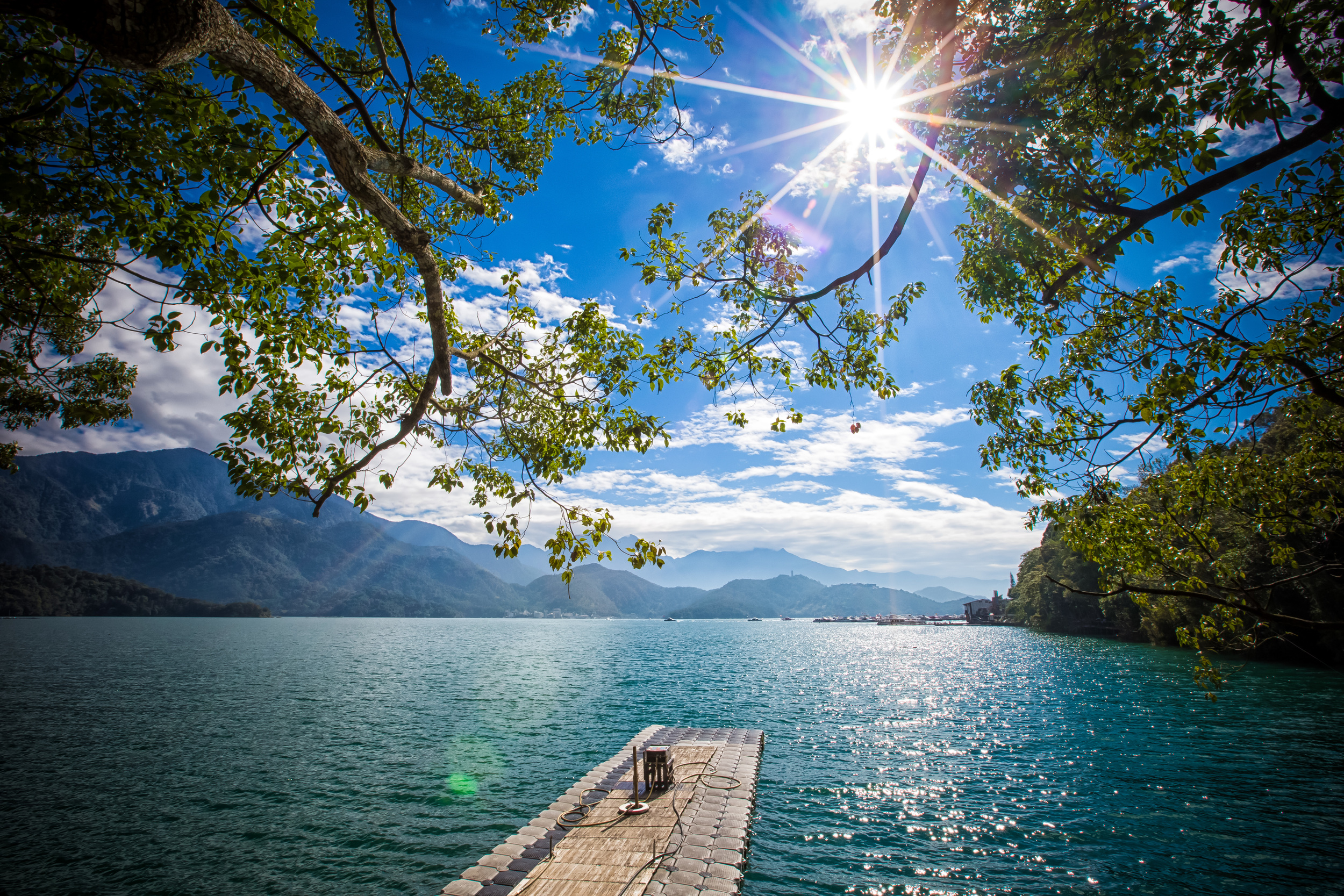
Sun Moon Lake is majestic and even though its not actually that big, its easy to see why it is the pride of Taiwanese people from every part of the country.

Oddly enough, Sun Moon Lake is so popular that it also appears on one of the pages of the most recent version of the passport of the People's Republic of China (not to be confused with the Republic of China) despite it not even being within the territory that it actually governs.

That is almost tantamount to Canada having Mount Rushmore in our passport. Nevertheless, that whole predicament is an argument for another day. 

The lake is situated in Taiwan's Nantou County (南投縣) and is surrounded by mountains on all sides.

Nantou happens to be one of my favourite places in Taiwan as its one of the most scenic areas for hiking with the Alishan scenic area (阿里山國家風景區) and the Yushan National Park (玉山國家公園.)

The county is directly in the middle of the country and gives easy access to some of the highest points of Taiwan's Central Mountain Range (中央山脈) with 41 of Taiwan's 100 mountains which have peaks over 3000 meters high.   

The lake is considered holy land and the area surrounding it is home to the “Thao” (邵族), one of Taiwan's Indigenous tribes which has unfortunately become one of Taiwan's smallest remaining (recognized) indigenous groups. 

Like many other indigenous groups in Taiwan who are still unrecognized by the central government, it took far too long for the Thao people to actually get the recognition they deserved when it came to their home and their claim that Sun Moon Lake is part of their holy land. 

Over the past century, they have had to endure the Japanese occupation which considered all indigenous groups “savages” and then the latter half of the century with the Chinese Nationalists who did their best to “sinicize” all of Taiwan’s indigenous people by forcing them to learn Mandarin and changing their way of life. 

They fortunately received recognition in 2001 as one of Taiwan’s ten different ethnic indigenous groups and the population has slowly started to rise due to efforts to preserve the culture.  

Lalu island (拉魯島), a small island in the middle of the lake is especially important to the Thao people, but has been used in the past as a popular place for weddings by other ethnic groups who came to the island.

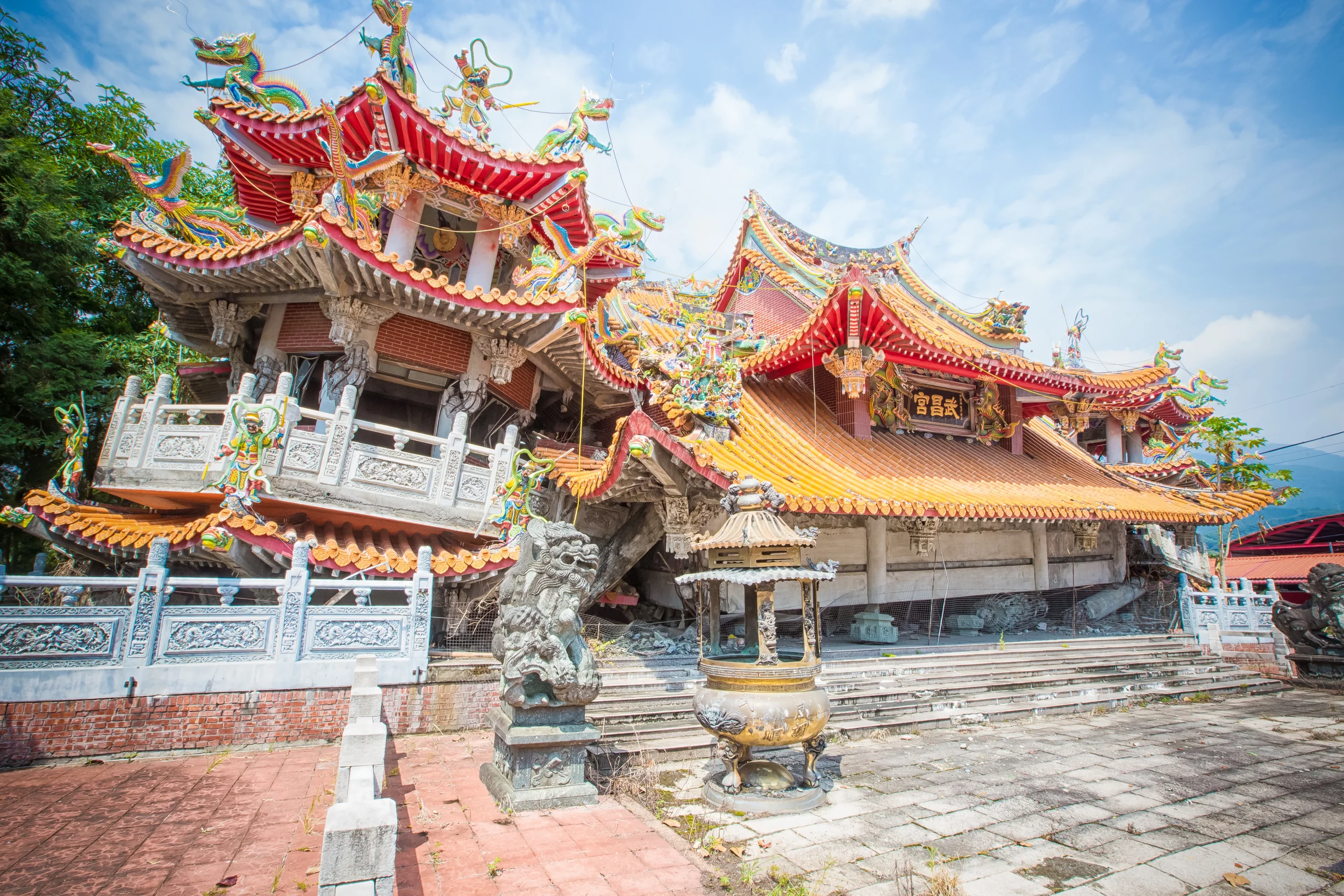
Even more unfortunate is that the island has suffered over the past century due to the construction of a dam that raised the water levels in the lake and the effects of the devastating earthquake on September 21st 1999 (九二一大地震) which rocked central Taiwan and wreaked massive destruction. 

Since the cooling of hostilities between the Republic of China (Taiwan) and the People’s Republic of China (China) tourism has become a major source of income for the area and what was once a very relaxing and peaceful area to visit has now become laden with development and littered with tourists who take boat rides across the lake ultimately causing a lot of pollution. 

When I first visited the lake years ago I thought it was a perfect escape from the bustling cities in the north. You could sit on the board walk and watch the sun rise or the sun set in perfect quiet.

When I visited this time however every five meters that I walked I was asked by somebody if I wanted a boat ride, which made me feel like I was touring somewhere in South East Asia.

The lake itself, despite all of this however is still beautiful. I visited on Christmas, and while most Canadians oddly wish for a white Christmas, I was perfectly happy with my colourful Christmas with the emerald green waters of the lake, the blue sky and the green mountains that surround it. It was also a nice escape from the weather in the north of Taiwan which at the time was pretty dreary. 

I didn’t have much time during this visit to Sun Moon Lake as I was just stopping by for a few hours before making my way up into to the mountains. I did have a nice walk around half of the lake and had an excellent view of the lake from the Starbucks by the boardwalk. 

I sincerely hope that the Taiwanese central government and the Nantou county government has the foresight to curb some of the development around the lake and do more to preserve the pristine beauty of the area so that future generations can enjoy it as much as we do now. 

If you have a chance to visit Taiwan, make sure Sun Moon Lake and Nantou is on your list of places to visit. 

Gallery / Flickr (High Res Shots)

The Pingxi Crags

- The view from the peak of Xiao-Zi Mountain (孝子山)

When I initially opened this site, I wasn’t really a man with a plan when it came to the direction that I’d be taking with this blog. After almost seven years though, when I look back at some of my earliest posts, it’s quite obvious that the way I write and present things here has changed considerably.

Which I hope makes for a much improved user experience.

Even though I’m always trying to take new photos and produce new content, but I also need to remember that it’s important to update older posts, too. It should go without saying that some of the places that I‘ve posted over the years have also changed, requiring an update on my part.

I’m going to start with this one.

Without fail, every year when I do one of my “Year in Review” posts, one of the blogs that is always at the top in terms of traffic has been this post about the Pingxi Crags.

With so much traffic landing here to learn about the crags, I feel like what I originally published seven years ago wasn’t even remotely helpful. So, I did a major overhaul of the post and added new photos.

When I first wrote about the Pingxi Crags almost seven years ago, the trail was well-known among those of us in Taiwan’s avid hiking circles, but that was about it. Even though Pingxi Village has always been a popular day-trip for locals and tourists alike, the hike wasn’t really on anyone’s radar.  

The crags however weren’t a secret that we were able to keep and the cat is certainly out of the bag about this exhilarating hike.

The trail is currently one of the most popular hikes in Northern Taiwan.

But you won’t find many of us avid hikers frequenting the trail.

We’ve been replaced by large weekend crowds of Instagrammers in search of photos for their ‘likes’ addiction.

If social-media love is something that you desire, a photo from the crags will undoubtedly help with that. 

The Pingxi Crags

The photo that everyone wants.

So what exactly are the Pingxi Crags? 

The Pingxi Crags are an exciting day-hike located in the historic Pingxi district (平溪區) of New Taipei City. In total, there are three peaks to climb and the best thing about them is that you can hike all of them in a couple of hours and still have enough time to check out Pingxi and enjoy all that the area has to offer. 

Each of the crags provides an amazing view of the surrounding area as well as the satisfaction of being at the top of a relatively high mountain, but with considerably less effort than other mountains. 

Obviously, the Pingxi Crags is a highly recommended hike for anyone living or visiting Taiwan and is well-deserving of its popularity.

That popularity however does create some issues.

Its important to remember that the trails are sometimes overcrowded and full of inexperienced hikers, which causes a bit of a traffic jam on the narrow and dangerous ridges.

If you visit the crags and the trail is jam-packed with people, remember to be patient, considerate and careful.  

The strange thing about the hike is that both foreigners and locals refer to them in completely different ways. In English, we often use the term “Pingxi Crags” to refer to the group of three rugged rock face cliffs, but in locals almost always refer to them as three separate mountains.

So, if you’ve been looking, its not likely that you’ll find much of anything resembling the term “Pingxi Crags” in Chinese. 

The three peaks are Xiaozi Mountain (孝子山), Putuo Mountain (普陀山) and Cimu Peak (慈母峰) and are actually just three rock-face crags that are part of a much longer trail that extends further on to Stinky Head Mountain (臭頭山) or the Central Ridge (中央尖).

Each of the crags has been given somewhat of a philosophical name and to compliment each of them you’ll also find quite a few religious images on each the trails and peaks. 

  • Xiaozi (孝子) - Pious Son

  • Cimu (慈母) - Motherly Love

  • Putuo (普陀) - Named after Mount Putuo, one of China’s sacred Buddhist mountains.  

The view of Pingxi Village from the top of XIaozi Mountain.

Even though there are three mountains to climb, I think its important that readers realize that not all of these crags receive the same amount of attention from the weekend crowds.

These days, if you show up during a busy period, you’re likely to only really encounter crowds of people wanting to hike to the peak of Xiaozi Mountain. 

More often than not, this means that the trails to the other two are much less busy. 

This shouldn’t really be a big surprise as Xiaozi Mountain is the go-to destination on the trail for all your popular instagram photos.

Take it from me though, if you travel all the way to Pingxi just to hike this trail and you only hike one of the crags, you’ll have wasted your time.

The other two crags are beautiful and also offer some great opportunities for photos. So spice things up a little - You don’t have to take the exact same photo as everyone else!  

Below, I’ll introduce each of the three Pingxi Crags, and hopefully in the process persuade you to hike more and go further than your average Instagrammer!   

Xiaozi Mountain (孝子山)

- Xiao-Zi Mountain rising up out of the forest.

Height: 360m

The most popular and obviously coolest of the three crags, Xiaozi Mountain is the primary destination for almost everyone hiking the crags.

The rocky crag rises high out of the valley but with a total height of only 360 meters, its the smallest of the three.

You might be wondering why the smallest of the three crags is the most popular? Well, its probably because Xiaozi Mountain rises up out of the valley all by itself, separated from the other two and features a small rigid peak that is only really capable of safely accommodating a couple of people.

Once you’re at the top, it is easy to feel a sense of vertigo while looking down, which is something that you won’t really get from the other crags and makes it great for photos.  

From the trailhead, you’ll only have to hike for around five to ten minutes before you reach a fork in the road.

To your left is the entrance to Xiaozi Mountain and to the right are the entrances to the other two crags. 

Don't look down

Don't look down

The entrance to Xiaozi Mountain requires you to walk up a steep set of stairs that have been carved out of the side of the mountain. 

Once you pass by the stairs, you’ll arrive at an area where the hike starts to become a bit more dangerous.

You’ll follow the trail around the crag which will take you up a ladder that has been fastened to the mountain. 

At this point, if you are afraid of heights, its probably better to turn back as the hike up and back down can be a bit nerve-racking. 

The stairs on the ladder are easy enough to climb but if you are unaccustomed to this kind of thing, it can certainly be a bit scary.  

Once you’re at the top, you’ll be greeted by a few Buddha statues and a 360 degree panoramic view of the forest and the village below. 

The stairs to the top of Xiaozi Mountain (孝子山)

As I mentioned above, if you are traveling on a weekend, you should definitely expect that there will be quite a bit of traffic trying to get to the top of Xiaozi Mountain.

This means that you may have to wait in line on the trail, which adds an element of danger in hiking the trail. It also means that you might not have a lot of time at the top as the narrow peak can handle no more than ten people at a time. 

Make sure to be careful and take it slowly. 

Putuo Mountain (普陀山)

- The path to the top of Putuo Mountain (普陀山)

Height: 450m

Putuo Mountian is the highest of the three crags, but just because it is the highest doesn’t necessarily mean that its the most exciting.

Admittedly, this one is probably my least favourite of the three crags, but thats only because I find that there is very little for you to actually see at the top.

The trail to Putuo Mountain however is probably the one that is most useful and widely travelled by avid hikers. The reason for this is that the trail leads you not only to the peak, but also branches off and allows you to connect to Cimu Mountain as well as the trail that takes you further beyond to the other mountains.

Buddha Statues at the top of Putuo Mountain (普陀山)

At the top of Putuo Mountain, you are greeted by a small Buddhist shrine and a larger statue of the Buddhist deity Guanyin at the end of the path.

Unfortunately even though there is a section of this crag on the way up that is really cool, the actual peak is a let down as it is mostly tree covered and doesn’t offer much in terms of a view.

It actually seems more like a shrine than a mountain peak.

Nevertheless, I recommend taking an extra few minutes to summit the peak of this crag before heading back down to connect with the trail to Cimu Mountain. 

Cimu Peak (慈母峰)

The ridge path up the side of Cimu Mountain (慈母山)

Height: 410m 

Cimu Peak is probably my favourite of the three crags (in terms of climbing) because it gives hikers the choice of either climbing up a steep open ridge with stairs carved into the rock face or taking a much easier route up a tree-covered mountain path.

The two different methods of climbing allows novice hikers, or those who are afraid of heights to take an easier path to the peak while the more experienced of us elect to walk up the steep mountain steps on the open ridge.

And that ridge? Wow. It’s a good time.

Strangely, while the other two crags are referred to as “mountains”, this one is instead referred to instead as a “peak” (峰), mostly due to the fact that it is part of the much larger mountain range.

As it is more of a ridge, most of it is climbed with the help of ropes and ladders and it doesn’t matter if you take the easy route or the more difficult one, you’ll still be able to enjoy the ridge walk, which is really cool and offers great views of the two other crags and Pingxi Village in the distance.

The fact that there are so few people hiking this one also allows you to stay at the top for a bit longer to take photos and enjoy yourself. 

It’s also a pretty convenient place if you’re climbing in groups as you’re able to split up with part of your group heading to the peak of Xiaozi Mountain and the other heading to the peak of Cimu Mountain to take cool photos of each other. 

If you plan on hiking all of the crags, I recommend first climbing Xiaozi Mountain, then heading to Putuo Mountain and ending your hike at Cimu Mountain.

Even though it may seem like you’re hiking the smallest to the largest to the middle-sized one, the route makes a bit more sense in terms of the distance you travel. 

Once you’ve completed the hike and have arrived back in Pingxi, you can grab some snacks and watch some of the famous sky lanterns taking off before hopping back on the bus or the train to head home.

Although, you’ll probably have noticed a bunch of sky lantern garbage strewn about the trail on the hike and you might have already realized that they’re pretty terrible for the environment, so maybe you won’t.

It’s up to you.

The Pingxi Crags are an easy hike as far as ‘hiking’ goes, but they aren’t for the faint of heart. It goes without saying that if you have a fear of heights, this hike probably isn’t for you. 

If however you are interested in making your time on earth just that much more awesome, this hike is definitely for you and is a great day-hike that can  

Getting There


The trailhead for the Pingxi Crags is located a short distance from the Pingxi Railway Station (平溪車站) on the historic Pingxi Railway Line (平溪線). 

The easiest way to get to the crags is obviously to have your own means of transportation. This will save you a considerable amount of travel time but also hiking time by allowing you to drive directly to the trailhead.

Whether you’re driving a car or a scooter, what you’ll want to do is first get yourself to Pingxi and once there drive up the steep mountain road to the trailhead. 

Simply copy and paste the address below into your GPS or Google Maps and you’ll have no problem getting there.   

Address: Section 2. Jing-an Road. Alley #294 (靜安路二段294巷)

The problem for everyone else is that if you are relying on public transportation to get to Pingxi, taking the historic rail line might not be the most convenient option if you’re hoping to hike this trail. 

The reason for this is that you’ll first have to take a train to Ruifang Station (瑞芳車站) and once you’re there, purchase a day pass, switch to the Pingxi line and then take the train all the way to Pingxi Station.

There are several issues with this:

  1. Pingxi Station is at the far-end of the rail line and will take about forty minutes from Ruifang station.

  2. It also doesn’t factor in the amount of time you’ll have to wait for the Pingxi train to depart, which might delay you by an hour if you’re unlucky. 

Instead, what I recommend is that you make your way from Taipei to the Muzha MRT Station (木柵捷運站) and from there hopping on Bus #795, which departs every fifteen minutes. 

The reason why I recommend this method is because the bus takes you directly from Taipei to Pingxi, but does so from the opposite end as the train, allowing you to arrive at the trailhead much faster

Link: Bus #795 - (Muzha to Shifen / 台灣好行795)

Sunset at the top of XIao-Zi Mountain (孝子山)

If you’re coming from the east coast or from outside of Taipei, there’s also another bus option that will take you directly to the trailhead.

Unfortunately this bus doesn’t come very frequently and I’d probably only take it if I had just missed the train.

From Ruifang Train Station you can hop on Keelung Bus #846 (基隆客運846) from Ruifang to Pingxi Junior High School. 

Link: Keelung Bus #846 | Real-time Map

If you have your heart set on taking the historic rail line into Pingxi and aren’t in a big hurry to get to the trailhead, all you’ll have to do is take a train to Ruifang Station where you’ll get off the train, head downstairs and follow the directions to where you can purchase your Pingxi Railway Day Pass.  

The day pass costs NT$80 and offers unlimited access to the train and gives you the freedom to get on or off at any of the stations. 

If it is your first time to the area, then by all means, take the train.

I highly recommend it. Its something that every tourist in Taiwan should do.

Link: The Pingxi Line - Through the Verdant Valley (Taiwan Everything) 

A Japanese-style Buddha along the trail.

If however you’ve already done all that and you’re only coming to town to hike the crags, just take the bus. 

If you take either of the buses, you’ll have a head start as you’ll simply get off at the Xiaozishan or Pingxi bus stop.

If on the other hand you take the train, you’ll just have to cross the bridge from Pingxi Station and then start your hike. 

No matter which method of public transportation you choose, you’re going to have to be prepared for a long and steep hike to the actual trailhead.

This part of the hike is probably the most annoying and difficult.

  • If you get off the bus at the Xiaozishan bus stop, you’ll have to walk up a steep paved road to the trailhead.

  • If you get off at the Pingxi bus stop, you’ll have access to convenience stores and a forest path that meets up with the road mentioned above and brings you to the trailhead.

I personally recommend getting off the bus at the Pingxi stop so that you can stock up on water and snacks for the hike.

- A Taiwanese woman preparing a sky lantern in Pingxi

I hope that this update not only provides the information necessary for hiking the Pingxi Crags, but has also persuaded you to hike all three of them.

For most tourists, getting to Pingxi isn’t the easiest of endeavours, so if you’ve come all this way, you might as well complete the entire hike.

I do however realize that there is a lot to see and do while in Pingxi, so if you only hiked the one crag and then moved on to some of the other destinations in town, I wouldn’t judge you too much. 

No matter how many crags you climb, the important thing is that you stay safe and have fun.


Gallery / Flickr (High Res Shots) 

Xiao Wulai Waterfall (小烏來瀑布)

Xiao Wulai Waterfall from the start of the hiking trail

Xiao Wulai (小烏來) or "Little Wulai" is a scenic waterfall park in the mountains of Taoyuan (桃園) in Taiwan that features several large waterfalls, hiking paths, hot springs, and the opportunity to experience a bit of Taiwan's Indigenous culture. 

The area is often confused with the Wulai District (烏來區) of New Taipei City (新北市). The Wulai area in New Taipei City also has a giant waterfall, but its more well-known for its hot springs resort area where people like to go to enjoy a nice hot volcanic bath during the cold winter months. 

Both areas are inhabited predominately by the Atayal tribe (泰雅族) one of the largest of the Indigenous groups in Taiwan. In the Atayal language, both areas were known as “Ulay” (Kiluh-ulay) which referred to the volcanic hot springs found in each.

Coincidentally “Kiluh-Ulay” translated into English loosely means “Be careful, the water is hot.” (小心水很燙) 

When the Nationalist Government took control of the island, both areas names became known as “Wulai” (烏來) which was transliterated from the Atayal language into Mandarin.

Xiao Wulai likely became known as "Little Wulai" at the time because the waterfall in New Taipei City is much higher (but not nearly as beautiful as Xiao Wulai)  

I’ve usually visit the park at least once a year and have explored the area many times. Its not a short drive from where I live, but its a beautiful drive that takes you away from the noise, commotion and pollution of the city through the Daxi river valley and up into the Indigenous village of Fuxing (復興鄉) where the air is clean, the water is fresh and the pace of life is much slower. (And during the summer months, you can find peaches everywhere.) 

If you continue driving past the Xiao Wulai park the road eventually takes you across the Fuxing bridge up into Baling (巴陵) and across the famous Northern Cross Highway (北部橫貫公路) which is well known for its mountain views and ultimately brings to you back down into Yilan county (宜蘭縣) on the eastern coast of Taiwan. 

- The walking path to Xiao Wulai Waterfall's base.

Each time I’ve visited the park there have been constant noticeable changes. The county government has been investing a lot in the area over the years trying to make “Xiao Wulai” a popular tourist destination. I have to admit that my first few visits were the best when the area wasn’t developed very well. There was a simple hiking path that would take you to the base of the falls and other paths that would take you around the falls and behind it to the Dragon-Phoenix Waterfall (龍鳳瀑布).

During these earlier visits there was easy access to the the base of the falls, but for obvious safety reasons there are now barricades stopping people from getting too close (as it would be too dangerous to have a bunch of tourists trying to navigate around a bunch of wet rocks and a giant waterfall.) 

The good news for the majority of tourists is that the government has recently invested almost $8 million New Taiwan Dollars ($250,000 USD) into the construction of a skywalk that allows tourists to walk on a transparent glass floor that is very close to the top of the falls and 70 meters above the base. This was a major tourist attraction when it first opened and the lines were huge. I hadn't actually tried walking across the skywalk until my most recent visit and even then I wasn't particularly interested (which is why there are no pictures of it.)  

As an avid hiker and nature photographer, I’m not particularly interested in that kind of tourist trap and I’d much prefer to take the short and very easy one hour hike from the falls observatory down to the base and enjoy the mountain air and scenery away from the crowds. 

- Under the viewing bridge at the base of Xiao Wulai

Since the completion of the skywalk and due to its popularity, the majority of people visiting the park will make their way in that direction. The well-developed pathway to the base of the waterfalls is relatively empty - So once you arrive at the falls, if you are so inclined, it is easy to climb under the bridge and get a bit of a closer view of the falls.

You do need to exercise caution though. The river running from the base of the falls can flow quite quickly, especially during the rainy season and rocks are often wet from the rain and the constant mist, so its very easy to slip. You’re no where near a hospital and should anything serious happen, you’d be out of luck. 

The Xiao Wulai Waterfall is one of the biggest and said to be one of the most beautiful waterfalls in northern Taiwan. It is considered special because you can see it from close up and from a distance due its location in a clearing in the mountain.

There is a constant heavy flow of water from the waterfall during both the rainy season and the summer months so any time you visit you’ll have no problem enjoying the natural beauty of the area. 

From the base of the falls you can make your way back up to the trailhead or go back to take another path which will lead you around the mountain and ultimately behind the falls to where they are currently constructing a new pathway and observatory for the Dragon-Phoenix Waterfalls. (Often incorrectly named the Double-Dragon waterfalls) It wasn’t possible during this visit for me to get to see both layers of the Dragon and the Phoenix waterfalls because the top layer was closed due to construction.

- Xiao Wulai Waterfall from the base (小烏來瀑布)

The area around Wulai has developed quite a lot over the years and there are now restaurants, coffee shops and vendors selling food as well. There are new hotels opening in the village near the falls and you can also enjoy some swimming areas during the summer months.

If you do visit Xiao Wulai, you need to make sure to sample some Indigenous food which if you ask me, is probably one of the best styles of food found in Taiwan. The area is well known for its mushrooms, so be sure to try some deep-fried mushrooms, some wild boar, rice baked in a bamboo shoot and any of the awesome mountain vegetables that you won’t find on tables anywhere else in the country!

- Dragon Pheonix Waterfall (龍鳳瀑布)


Getting There


No. 3 National Highway (國道三號) -> Dasi Interchange (大溪交流道) -> Dasi (大溪) -> Fuxing (復興) -> No. 7 Provincial Highway (台7線) -> Xiayun Bridge (霞雲橋) -> Xiao Wulai Scenic Area (小烏來風景區)

By Scooter/Motorcycle

From Taoyuan (桃園) or Zhongli (中壢)make your way to Dasi (大溪) -> Fuxing (復興) -> No. 7 Provincial Highway (台7線) -> Xiayun Bridge (霞雲橋) -> Xiao Wulai Scenic Area (小烏來風景區)

Gallery / Flickr (High Res Shots)