淡水

Tamsui Police Commissioners Residence (淡水日本警官宿舍)

I’ve you’ve lived in Taiwan long enough, you may have noticed that the Taipei MRT has changed the romanized name it uses for Tamsui Station (淡水捷運站) on a couple of occasions. Whenever these things happen, it usually follows with heated public debate and questions as to why they’re once again wasting money on these unnecessary changes. Suffice to say, whatever ‘official’ reason is given for the change, most people know that they’re actually politically motivated.

Correct me if I’m wrong, but I remember during the most recent incident, one of the reasons given for the change to ‘Danshui’ was that International tourists couldn’t pronounce ‘Tamsui’, so they had to change it to something more recognizable. ‘Danshui’ which is the Mandarin pronunciation romanized into Hanyu Pinyin (漢語拼音) was thought to be more foreign-friendly than the original name of the area, ‘Tamsui’, which is the Taiwanese-Hokkien pronunciation. Nevertheless, the change didn’t last very long as it was quickly changed back.   

Given that the area has been referred to as ‘Tamsui’ for hundreds of years, it comes across as a bit odd that there are all of these contemporary naming issues, but Taiwan can be a pretty complicated place at times, and it’s well-known that the Chinese Nationalists were never really big fans of the local language. The irony however, is that during the Japanese-era, the original name remained exactly the same. During that half-century period, ‘Tamsui’ (淡水) simply became known as Tansui (淡水郡 / たんすゐぐん), the Japanese pronunciation of the original name.

Geographically, the Tamsui District (淡水區) of today is considerably smaller than the Tamsui District (淡水郡) of the Japanese era, in that the latter consisted of districts that currently make up New Taipei City’s Shimen District (石門區), Sanzhi District (三芝區) and Bali District (八里區) - known during the Japanese era as Sekimon-sho (石門庄 / せきもんょう), Sanshiba-sho (三芝庄 / さんしょう) and Hachiri-sho (八里庄 / はちりしょう) respectively. The district also included the main town of Tansui (淡水街 / たんすいまち), where a considerable amount of commerce and international trade was taking place.

The area ended up being so vital to the Japanese colonial government that they quickly got to work on the construction of the twenty kilometer-long Tamsui Branch Line (淡水線 / たんすい) that followed the east bank of the Danshui River from the capital. The railway was a game changer for the district, which originally acted as a port of trade with China, in turn sending products down the river into Dadaocheng (大稻埕) or Bangkha (艋舺). The completion of the railway in 1901 allowed for a more efficient process of getting things to the capital, making the port town an important one for the colonial government with regard to transporting things from the Japanese mainland to Taiwan, easing some of the congestion from the other northern port in Keelung (基隆). More importantly however, the branch railway kept the people of the area connected with the capital in a way that ensure that it would always remain an important part of Taipei.

Note: The Tamsui Line consisted of the following stations: Daitotei (大稻埕), Hokumon (北門), Taihoku (台北), Taishogai (大正街), Soren (雙連), Maruyama (圓山), Miyanoshita (宮ノ下), Shirin (士林), Kirigan (石牌), Hokuto (北投), Kanto (關渡), Chikui (竹圍) and Tansui (淡水). For those unaware, these historic stations, which were in service from 1901 (or added in 1915) and make up much of what is today the Red Line (紅線) of the Taipei MRT, which replaced the original railway.

The ability to maintain it’s economic prosperity meant a lot for the people of the area, which is something that continues to be celebrated today with both domestic and international tourists making their way from the city to enjoy the Tamsui Old Street, it’s beautiful riverside, and a large number of historic buildings and tourist destinations. The prosperity enjoyed by the people of Tamsui during the colonial era is clearly visible along the old street today, where the architectural design of the buildings is indicative of what we’ve come to expect from any of the historic “Old Streets” (老街) that have been converted into tourist destinations.

Covering an area of 227km², and with a population of nearly 60,000, Tamsui was one of the many districts under the governance of Taihoku Prefecture (台北州 / たいほくしゅう). In 1920 (大正9年) however, the colonial government refined and redistricted Taiwan’s geographic and administrative system. This was when  ‘Tansui District’ (淡水郡), or county depending on your translation, was brought to life. The changes in administrative control required the construction of a new town hall, namely the Tamsui Town Office (淡水郡役所 / たんすゐぐんやくしょ) in addition to a number of new civic buildings in the port town including the post office, telecommunications office, etc. Likewise, even though there was already a police presence in the area, the redistricting now meant that police service in the area would be carried out by the local Tamsui Police Branch (淡水郡警察課) of the Taihoku Prefectural Police Service (台北州警務部).

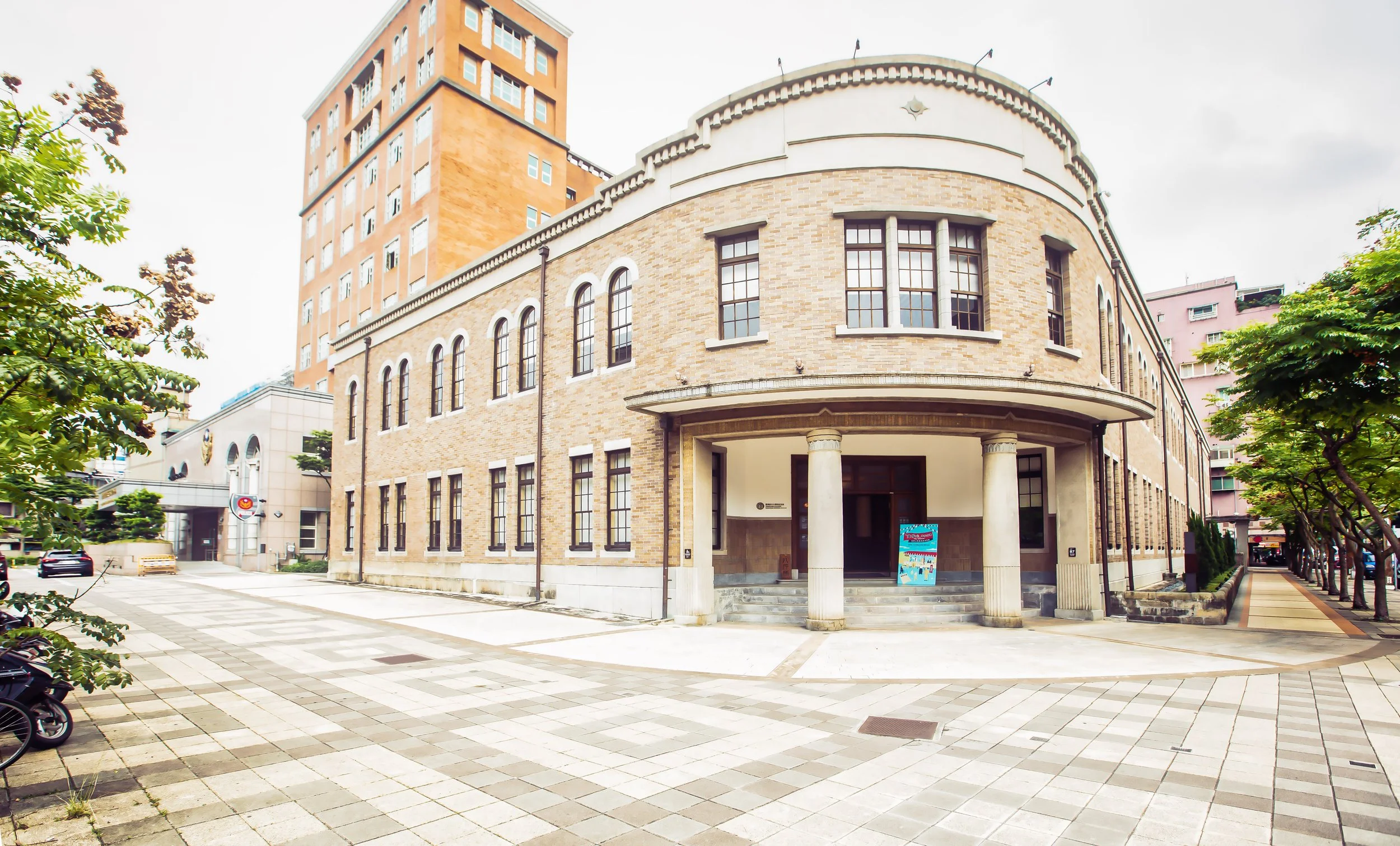
All of this new local governance brought with it a number of important positions that had to be filled, similarly requiring a number of new official residences. While there were already a number of official residences in the area made available for teachers, police and other civil servants, the redistricting required the construction of housing for the mayor and the police chief, among others. Unfortunately, unlike a lot of other areas around the country, many of these official residences in Tamsui have already been torn down to make way for modern construction projects, making the few that remain quite important. Today, I’ll be introducing one of them, namely the former residence of the Tamsui Police Chief.

Recently restored and re-opened to the public as a tourist destination, the house is one of the few remaining wooden residences in Tamsui today, and given its proximity to the old street, it makes for an interesting stop if you find yourself in the area for the day.

As always, I’ll start by explaining the history of the residence, followed by its architectural design, and then end by offering directions on how to get there.

Tamsui Police Chief’s Residence (淡水日本警官宿舍)

Coinciding with the establishment of Tamsui District in the 1921 redistribution of Taiwan’s administrative regions, a number of buildings were constructed within the port town to facilitate the administrative upgrade the town was receiving. One of those buildings was the official residence provided to the district’s Police Chief.

Constructed a short distance from the Town Office mentioned above, the modest residence was built on the side of a hill that overlooked the bustling commercial area of Tamsui and the river, with a nice view of Guanyin Mountain in the distance. In terms of it’s size, the Japanese-Western fusion style residence was modest to say the least, especially in comparison to some of its contemporaries.

Unfortunately for all of the Police Chiefs who served in Tamsui over the next two and a half decades of the colonial era, and then into the post-war era, the building was constructed a year prior to the Governor General’s Office enacting a law (台灣總督府官舍建築標準) regarding official building standards in Taiwan - Those new standards specified a clear set of regulations regarding the size of buildings provided for civil servants of various ranks, divided between Senior Officials (高等官 / こうとうかん) and Junior Officials (判任官 / はんにんかん). Meant to improve the living standards in the housing provided for civil servants as well as to encourage staff to work hard and earn a promotion in order to receive more comfortable housing for their families.

Granted, the Police Chief of Tamsui District wouldn’t have been on the same level of the bureaucratic hierarchy as the Police Commissioner of Hsinchu, but if you compare the two residences, you’ll notice a considerable difference in their size.

Link: Shinchiku Police Commissioner's Residence (新竹州警務部部長官舍)

According to my research for the article linked above, under the new housing system, the Police Commissioner’s Official Residence was classified as a Level Two Senior Official (高等官官舍第二種) house, meaning that the building should be at least 165㎡ (50坪) in size accompanied, by a plot of land that was at least 1003㎡ (303.5坪). The Tamsui District Police Chief (淡水郡警察課長), however would have been considered a Level Four Senior Official (高等官官舍第四種) and thus would have been afforded a residence up to 109㎡ (33坪) in size, with a plot of land up to 440㎡ (132坪). Constructed a year prior to the new regulations, the residence is 73㎡ (22坪) in size and the total size of the land is 241㎡ (73坪), considerably smaller than it would have been if it were constructed a year later.

If you’re wondering why I’ve gone off on this size tangent, the answer comes in a few different forms - The first being that it would have been one of the reasons that the position as the Police Chief of Tamsui district would have been considered a stepping-stone to something bigger and better. This will become more obvious in the list of residents I’m providing below. The second reason is that in the post-war era, the residence continued to be occupied by the local police chief, but when the housing crisis in Taiwan (brought on by the influx of several million Chinese refugees) stabilized, officials elected to find their own housing.

Below you’ll find a list of the residents of the building during the Japanese era, or at least from 1921-1945. You’ll notice there was quite a turn around for these Police Chiefs, but it’s not that the job was terrible, as mentioned above, it was essentially a position that would have propelled people to bigger and better things. In each case though, whether it was for a few years, or a few months, the residence was made available to the chief and his family.

Japanese-era Residents (淡水郡警察課長)

  1. 1921 (大正10年) 竹內健藏

  2. 1924 (大正13年) 高橋秀二

  3. 1924 (大正13年) 手貝千代志

  4. 1925 (大正14年) 倉持泰

  5. 1926 (昭和元年) 高橋政吉

  6. 1927 (昭和2年) 小泉清

  7. 1928 (昭和3年) 蘆田俊

  8. 1931 (昭和6年) 酒井林藏

  9. 1936 (昭和11年) 金丸繁治

  10. 1938 (昭和13年) 清水增吉

  11. 1939 (昭和14年) 久保田豐太郎

  12. 1941 (昭和16年) 神代文治

When Japan surrendered at the end of the Second World War, the shame of defeat was too much for some of it citizens, especially for some of the police who had also served as members of the military. In what is possibly the first case I’ve come across where something like this happened, the humiliation of defeat was so unbearable that two of the residents of the house hung themselves inside, which would cause some complications during the post-war era.

From what I found during my research, the residence continued to serve as the official residence for the Police Chief of Tamsui in the post-war era - The thing is though, that no one lived in the building until a few years after the arrival of the Chinese Nationalists. Given the housing crisis that took place in the early years of the Nationalists retreat to Taiwan, it’s a bit strange. The reason for this, I’m assuming was based on a couple of different reasons - The first is that the house was constructed on the site of a Qing-era graveyard. The second is that the two Japanese who hung themselves in the building would have made it a ‘haunted house’ (凶宅) according to Chinese cultural standards.

It wasn’t until 1951 (民國40年) that the house started being occupied again. Similar to what happened during the Japanese era, the men who served as Police Chief in Tamsui only ever lasted for a few years, with the house being occupied by a number of police chiefs, including Sun Zhao (孫肇), He Qi (何琦), Chang Yifei (張一飛), Chang Jianxun (張建勳) and Jin Fuhai (金福海). Going back to a point I made earlier though, as the housing situation stabilized in Taiwan, few actually wanted to continue living in the residence provided to them.

Thus, the last official residents of the building were the Deputy Police Chief (淡水警分局副分局長), Jin Fuhai and his wife Lin Meimei (林美美) who moved into the residence in 1968 (民國57年). Living in the house long after the death of her husband, Lin Meimei enjoyed the comfort of the historic building for well over four decades until she moved out in 2007 (民國96年). Ms. Lin could have lived out the rest of her life in the house, but even though she absolutely loved all the time she spent there, she also recognized that if she continued living there, the nearly one-hundred year old historic property would eventually be lost completely, like so many of Taiwan’s other historic buildings. Vacating the residence in 2007, the building was quickly registered as a protected New Taipei City Historic Property (新北市歷史建築) that same year, with plans to have it restored.

Sitting abandoned for over half a decade, Ms. Lin was unimpressed with the long bureaucratic process that slowed down the restoration of the building and it’s reported that she pressed authorities on several occasions throughout the years to start the restoration work before it was too late. Still, it took until 2013 for the government to send researchers to the building to start the process of documenting the building and coming up with a plan for its restoration. The restoration proposal was completed in 2015 and the government opened up a tender for companies to bid on the project. Finally, twelve years after Ms. Lin moved out, the historic residence was reopened to the public in December of 2019 under the operational control of the Tamsui Historical Museum (淡水古蹟博物館), which curates a number of exhibits within the many historic buildings in the area.

Although it may seem like I was criticising the size of the building earlier, it is actually one of the buildings strongest aspects at the moment as they haven’t been able to fill it with a bunch of pointless exhibition pieces; It’s possible that this could change in the future, but during my visit, I highly enjoyed that the few things put on display within the building focused solely on its history and architectural design. They didn’t add a bunch of needless display pieces to take up space, they just left the building open, which allows visitors to enjoy the space a lot more than a lot of the other buildings that have been restored in recent years.

Now that I’ve gone over a bit of the history of the building, I’m going to spend some time explaining its architectural design.

Architectural Design

I had a bit of a good time with some of the ‘official’ descriptions of the residence’s architectural design, especially those coming from the government - Described as a fusion-style of architectural design, some of the information available about the building from the tourism bureau will claim that it is a fusion of Japanese, Western and Taiwanese design. While that is partly true, the building was originally designed as a Japanese-Western fusion (和洋並置), with what I suppose you could refer to as ‘Taiwanese’ elements added to the building in the post-war era.

The problem with describing these additions as ‘Taiwanese’ elements however doesn’t give much credit to Taiwanese architectural design. The residence was expanded during the stay of Police Chief Sun Zhao (孫肇), who lived there for seven years from 1951-1958. The expansion which merely added a reinforced concrete section to the back of the house provided a bit more space, but wasn’t inherently ‘Taiwanese’ in design, so I’d go as far as to say that anyone who makes these claims is doing a disservice to traditional Taiwanese design.

For you naysayers, I assure you, there is far more to Taiwanese architectural design than the pouring of concrete.

Not sure what happened here. It’s probably where the restoration team removed some of the additions.

As mentioned above, the residence is a total of 73㎡ (22坪), making it quite small in terms of Japanese-era houses. Nevertheless, the layout of the building adheres to traditional Japanese architectural design with the interior space divided into three separate spaces, a living space (起居空間), a service space (服務空間) and a passage space (通行空間). To explain, the “living space” is essentially a multi-functional space where the residents spend time together having meals, drinking tea and sleeping. The “service space” on the other hand includes a number of functional spaces including the kitchen, bathroom, washroom, etc. Finally, the “passage space” generally refers to the various entrances, and the corridors within. One of the important things to keep in mind with regard to traditional Japanese-style residences like this is that the fusion of all three of these spaces skillfully separates the ‘public’ parts of the home from the ‘private’ through the usage of walls, sliding doors and corridors that reach around the building.

As I’ve done in the past, I’ll make use of the floor plan to briefly introduce each of the various spaces within the residence to better explain their function. To make things easier to understand, I’ve numbered each of the space on the plan above so that you know which part of the house I’m referring to:

Passage Space (通行空間)

(1) The front entrance, or the ‘foyer’ to the residence is known in Japan as a ‘genkan’ (玄關 / げんかん), and features compartments for shoes, umbrellas, etc. The foyer is located on ground-level as opposed to the rest of the building, which is elevated. Once you enter the building you’ll find a set of stairs that brings you up to the core parts of the building. As part of the separation of the public and private parts of the home, the foyer has two doors, one directly ahead that leads to the private space and another on the left that leads to the reception room.

(2) Regarded as a ‘transitionary’ space, the ‘toritsugi’ (取次 / とりつぎ), or the second foyer was directly in front of the main entrance to the residence. Once you walked up the stairs to the main area, you’d find a small space with another set of sliding doors that opened up to the tea room. This space is somewhat ceremonial, but also functional in that it offers another storage space for coats, while the space below was reserved for shoes and umbrellas.

(3) What I’d consider the best part of living in this house, and the part of every traditional Japanese home that I appreciate the most is what is know as the ‘engawa’ (緣側/えんがわ). This is essentially a wide corridor on the side of the building that overlooks the river and features sliding glass doors that open up to the yard in addition to sliding panels that open up to the living space, with another door connecting to the guest space. The sliding glass doors would have allowed for a significant amount of natural air to breeze through the residence, offering a natural air conditioner of sorts, but the best part of this space is that the residents could spend hours sitting on the covered veranda watching the hustle and bustle of the street below as well as the boats passing by in the river.

Finally, within the building you’ll find a number of corridors that connect each of the spaces with each other. I haven’t listed each of them on the photo above, but the ‘rou’ (廊 / ろう) are essential in these buildings as they play an integral part in separating each of the spaces. Most of them are located on the northern and southern sections of the building, with the middle section reserved as the living space.

Living Space (起居空間)

(5-6) Within the private area, you’ll find the most spacious area of the home, which is typically separated into two sections known as the ‘zashiki’ (座敷 / ざしき) and the ‘ima’ (居間 / いま), which together act as what we’d consider a ‘living room’ and a ‘bedroom’ however, they’re a bit more complex than that. Within the ‘ima’ section, which acts as the sleeping space, you’ll find alcoves known as ‘oshiire’ (押入 / おしいれ), which are used for storing bedding during the day.

Likewise, within the ‘zashiki’ you’d find similar alcoves known as tokonoma (床の間/とこのま) and chigaidana (違棚 / ちがいだな), which are both spaces reserved for decorative elements of the living space. In these traditional homes, sleeping spaces were communal, and the living space was used by the family as a space to hang out, or entertain close friends.

The important thing to remember is that during the day all of the clutter would have been stored away, making these two spaces quite open and enjoyable. One of the things to take note of when you’re in the living space are the sliding wooden panels that can be closed to separate the two spaces. These panels are said to be originals and feature some beautiful calligraphy-style paintings on either side.

(7) Separated from the foyer and the waiting room by a sliding door, you’d find what was known as the tea room (茶之間 / ちゃのま), which essentially served as the dining room as it was connected directly to the kitchen. In smaller residences like these, the tea room also acted as a reading room (書齋 / しょさい) when the larger reception space wasn’t being used.

(8) One of the spaces that was extended over the years, the ‘ousetsushitsu’ (應接室 / おうせつしつ) could go by a number of names in English; Essentially it was a meeting room, or a space where residents could receive guests. Over the years, the various Police Chiefs likely received guests during their off-hours to discuss work-related issues. Separated from the private area of the living space, it was connected to the rest of the house by the ‘foyer’ and the ‘veranda’ making it easily accessible whenever anyone visited. This is one of the ‘fusion’ areas of the house though as it was also considered a ‘western style’ living room with sofas and later a television, etc. Located in the southern corner of the house, the room would have had a nice view of the river and the afternoon sun.

Service Space (服務空間)

Finally, the ‘service space’ is admittedly the most difficult space of the building to explain, as most of it is not open to the public. These space were restored along with the rest of the building, but are currently occupied as spaces by the administration of the building as storage space. Nevertheless, for clarity sake, the service space included the (9) lavatory (便所 / べんじょ), the (10) kitchen (台所 / だいどころ) and the (11) bathroom (風呂 / ふろ). Truth be told though, tourists aren’t probably all that interested in checking out a one-hundred year old bathroom, right?

Now that I’ve explained the interior, let’s take a few minutes to talk about the exterior of the building. Constructed in the irimoya-zukuri (入母屋造) style of design, which basically means that the base of the building is smaller than the roof, the weight of which is supported by a network of trusses (屋架) in the ceiling that helps to support the weight of the four-sided sloped hip roof (四坡頂). However, when you look at the roof from above today, it is clear that the shape of the original roof has been altered considerably. Likewise, the the original roof tiles were replaced with plastic-looking tiles and the onigawara (鬼瓦) end tiles have all been replaced. Also, the wooden shitamiita (下見版 / したみいた) siding on the buildings has been replaced. They are currently quite dark in color, but as they age the colors will fade.

Although the additions to the building over the past century have increased its size, they have also altered the original shape. The space in front of the veranda is quite narrow as it overlooks the hill, while the space on the ends of the building on the kitchen side as well as the meeting room side have reduced the size of the space in the yard. These additions however haven’t really been reflected well in the restoration of the building, which offers a pretty good view of what the building would have originally looked like, with the additions making up the administrative sections of the building.

Getting There


Address: #5, Alley #12, Zhongzheng Road, Danshui (新北市淡水區中正路12巷5號)

GPS: 25.170740, 121.439940

Located within the heart of Tamsui’s Historic Old Street (淡水老街), the former Police Chief’s dorm sits on prime real estate just to the rear of what would have been one of the most important places of worship in town. A short walk up a set of stairs to the rear of Fuyou Temple (淡水福佑宮), otherwise known as the Tamsui Mazu Temple (淡水媽祖廟), the former residence is within walking distance of both the Tamsui MRT Station (淡水捷運站) as well as the Tamsui Ferryboat Wharf (淡水渡船碼頭), making getting there rather easy.

Taking into consideration that the Tamsui Old Street is quite narrow, your best option for getting to any of the tourist destinations in the area is to simply walk. The stretch of Zhongzheng Road (中正路) where the temple is located is quite narrow, making it difficult for buses to get in and out, but makes it great for pedestrian traffic with wide sidewalks.

From the Tamsui MRT Station, the walk to Fuyou Temple is about 550 meters, an estimated six minute trip according to Google Maps. To get there simply walk out of the MRT station and walk straight until you find yourself on Zhongzheng Road. Once you find yourself on the Old Street, simply walk straight until you reach Fuyou Temple. On either side of the temple you’ll notice a set of stone stairs that leads you up behind the historic temple to the residence, in addition to a neighborhood that overlooks the harbor and is close to a number of other historic tourist destinations.

While you’re in the area, in addition to the historic old street and the riverfront, you may want to also consider visiting the Tamsui Longshan Temple (淡水龍山寺), Tamsui Qingshui Temple (淡水清水巖), the Tamsui Customs Officers’ Residence (小白宮), the Tamsui Presbyterian Church (長老教會淡水教會) and the Huwei MacKay Hospital (滬尾偕醫館), all of which are within walking distance of the old street. Similarly, you may also want to visit Fort San Domingo (淡水紅毛城), the Tamsui Martyrs Shrine (新北市忠烈祠) or the Tamsui Fisherman’s Wharf (淡水漁人碼頭), which are both a little further away.

Recently restored and reopened to the public, the Japanese-era Police Chief’s residence is probably one of the lesser known of Tamsui’s tourist attractions, but that also makes it one of the most relaxing places to visit. There isn’t a whole lot to see when you visit the house, but the building has a great view of the harbor and you may want to sit on the veranda to take a break from your travels prior to moving on to your next destination. If you find yourself visiting on a hot day, the respite from the sun should be a welcome-enough experience for a weary traveler, especially with the peace and quiet offered by the house.

References

  1. 淡水日本警官宿舍 (Wiki)

  2. 淡水郡 | 淡水街 | 台北州 | 淡水線 (Wiki)

  3. 淡水日本警官宿舍 (淡水維基館)

  4. 淡水日本警官宿舍 (國家文化資產網)

  5. 新北市歷史建築淡水日本警官宿舍修復或再利用計畫 (新北市政府文化局)

  6. 終於修復完工!淡水「日本警官宿舍」開放參觀,重現日治時期「和洋折衷式」建築風貌 (Shopping Design)

  7. 淡水重建街添一好拍景點 超美日本高階警官宿舍今開放 (新北市政府警察局板橋分局)

  8. 日本警官宿舍 見證日本警察統治的漢人社會 (國家文化記憶庫)

  9. 淡水老街又ㄧ重要歷史建築將獲保存 前縣議員林美美老宿舍可望指定為歷史建築 (許慧明 / 淡水文化基金會)


New Taipei City Martyrs Shrine (新北市忠烈祠)

A few months ago, when I wrote my annual ‘Year in Review’ post for 2019, I mentioned that I was still unsure as to what my personal project for the new year would be - At the time there was a lot going on in the world and I felt a bit odd because I’m usually on the ball with these things.

I also always have a long list of places that I plan to visit, take photos of and write about. 

Looking back at that post now, I think I was probably a little naive.

Who knew that 2020 was going to turn out to be such a dumpster fire?

As I’m posting this, we’re eight months into the year and almost every country in the world has been turned upside down thanks to the Coronavirus.

As a side note, I’ve kept busy over the past couple months writing about all the wonderful places I visited in Vietnam and Thailand during my trip in January (just before things got out of hand), but I’ve also been putting a lot of consideration into what I’d focus on once it became safe to freely travel again.

I think I’ve finally figured that out. 

After receiving numerous emails and requests, I visited the National Revolutionary Martyrs Shrine in Taipei to get some photos and then wrote a blog about it.

If you’ve read the post, you’re probably aware that I’m not particularly a fan of these places (for various reasons), but while doing research for the post, I was reminded that the majority of the “Martyrs Shrines” that exist in Taiwan today sit on the site of a former Shinto Shrine from the Japanese Colonial Era

Considering that I’ve already written about the Taoyuan Shinto Shrine, Yilan Shinto Shrine, and the Tungxiao Shinto Shrine, all of which have been converted into Martyrs Shrines, I figured that I’d make one of my personal projects for the year link together with the other (ongoing) work I’ve been doing related to historic buildings from the Japanese Colonial Era.

It’s important to note that only in special cases do the Martyrs Shrines of today have much left with regard to the original design and layout of their Shinto Shrine days.

In most cases almost everything was torn down and new buildings were constructed in their place.

Fortunately though, we can still find evidence of the history of these locations through the layout of the grounds, the trees planted on the site and with the presence of objects like the the stone lion guardians, lanterns, etc.

By my count, there are currently fifteen Martyrs Shrines in Taiwan that were once Shinto Shrines and I’ve only covered four of them, which means I have another eleven to visit!

Over the next few months, I plan to travel around the country to check them out while also visiting some of the other spots on my long list of places to visit.

To start, I’m going to introduce the site of the former Tamsui Shinto Shrine (淡水神社), which has since been converted into the New Taipei Martyrs Shrine (新北市忠烈祠).

I’ll briefly talk about the history of the Shinto Shrine (with some historic photos) and then introduce the Martyrs’ Shrine that exists on the site today. 

The Martyrs’ Shrine isn’t exactly what most would consider a major tourist attraction (by itself), but it conveniently sits on a picturesque mountainside overlooking the Tamsui River (淡水河) and is fortunate to be neighbors with a handful of other historic tourist destinations that are within walking distance.

The shrine is known for its natural beauty and while it may not be busy with tourists, it has become a preferred setting for local photographers, who use the beautiful Japanese-era stonework and the pine trees as a backdrop for wedding photos. 

Tamsui Shinto Shrine (淡水神社)

Constructed on the Tamsui Shinto Shrine (たんすいじんじゃ) started in 1936 (昭和10年) and was officially opened three years later in 1939 (昭和14年).

Often considered one of the prettiest of all the Shinto Shrines in the greater Taipei area, the shrine overlooked the beautiful Tamsui River with Guanyin Mountain (觀音山) in the distance.

Highly regarded for the way it harmoniously blended with the natural environment, the shrine earned the title as one of the ‘eight scenic spots’ in Tamsui (淡水八景) in part thanks to the sando (參道), or the “walking path” which was lined with pine trees (something that thankfully still exists today). 

Not only was the walking path lined with trees on either side, but also a collection of stone lanterns (石燈籠) that lit the way at night. The walking path also had a Torii gate (鳥居) at both ends with two larger stone lanterns (大石燈籠) at the top of the hill.

The torii, which you can see from the historic photos below were both quite large and beautiful.

Once you reached the top of the hill you’d find a Purification Fountain (手水舍), where you’d be required to perform a cleansing ritual before entering the shrine.

On the opposite side of the fountain was the Shamusho (社務所), which acted as the Administration Office and living quarters for the priests who lived at the shrine.

As you continued along the path up the hill, you’d be met with a stone wall and a set of stairs guarded by two ‘Komainu’ stone lions (狛犬) with another Torii gate at the top.

Interestingly, although the lions and gate have since been replaced, the layout remains the same today. 

Once you passed through the Torii gate at the top of the stairs you’d find yourself in a courtyard full of trees with another gate known as the Middle Gate (神門) acting as the entrance to the shrine.

The Middle Gate was constructed of wood and was known for its traditional Kirizuma-zukuri gabled roof (切妻造) design that surrounded the innermost part of the shrine.

Once you passed through the Middle Gate you’d find the “Haiden” or “Worship Hall” (拜殿) in the middle of another courtyard.

Even though there are few pictures of the shrine available, what we do have shows us that the architectural design of the building was similar to that of what we can see today at the Taoyuan Shinto Shrine (桃園神社) with its impressive ‘Irimoya’-style hip-and-gable roof (入母屋造).

Unlike Chinese-style places of worship, you wouldn’t have found statues of the gods inside the worship hall, instead you would find a simple shrine with a mirror and behind that a door that led to the Honden (本殿) or “Main Hall”, which is traditionally off-limits to anyone except for the priest who resided at the shrine. 

The deities that were enshrined in the Honden were Prince Yoshihisa (能久親王), Emperor Meiji (明治天皇), Ōmononushi (大物主命) and Emperor Sutoku (崇德天皇).

In fact, most of the over two hundred Shinto Shrines constructed during the colonial era were home to shrines dedicated to Prince Kitashirakawa Yoshihisa, who was the first member of the Japanese royal family to pass away (outside of Japan) in more than nine hundred years. He died from what is believed to be malaria in Tainan in 1895, the same year that Japan took control of Taiwan. 

Link: Prince Kitashirakawa Yoshihisa (Wiki) 

I suppose you could say, the unfortunate thing about this beautiful shrine was that it was officially opened only a few short years before the Japanese Colonial Era came to an end.

When the Second World War ended in 1945, Japan was forced to give up its control of Taiwan, which was then ambiguously awarded to the Republic of China.

In 1953, the shrine officially became the Taipei County Martyrs Shrine (台北縣忠烈祠). which retained the original buildings until 1975 when it was bulldozed and converted into a Chinese-style shrine.

Today all that remains of the original shrine (in this location) are the beautiful pine trees that once lined both sides of the walking path, the stone wall, guardian lions (although they were replaced at some point) and the overall schematic design of the landscape. 

Hsing-Chong Temple (淡水行忠堂)

The good news is that not everything from the former Shinto Shrine has been destroyed. 

When the last remnants of the Tamsui Shinto Shrine were torn down in 1975, several of its pieces were transferred to nearby Hsing-Chong Temple (行忠堂) in the mountains of Tamsui.

The people at the temple were able to preserve sixteen of the original stone lanterns from the walking path, the two larger stone lanterns, the purification fountain and the original information board (揭示場) which you’ll often find at the entrance of shrines.

The amazing thing is that during the 1970s, the government was pushing an extreme anti-Japan policy that sought to demolish anything from the colonial era that was deemed unnecessary.

The fact that this small temple was able to preserve as much of the original Shinto shrine as they were was no small feat. The other amazing thing is that in order to preserve all of these pieces of the shrine, they had to find a way to transport them to their temple in the mountains. 

You might be thinking that’s not really that big of a deal, but the thing you need to realize is that getting around back then wasn’t as easy as it is today.

This problem was exacerbated by the fact that the lanterns would have weighed thousands of kilograms.

With a seven kilometer distance between the Shinto Shrine and Hsing-Chong Temple, a mixture of ox-pulled carts, rudimentary cranes and trolleys were used in addition to the the help of dozens of people to bring the pieces of the shrine to their new home where they can still be enjoyed today.

Why would this temple in the mountains of Tamsui, which is dedicated to Guan Gong (關聖帝君), want to preserve these pieces of the Shinto Shrine you ask? Well, thats not really very clear.

Your guess might be as good as mine.

When I enquired with the caretakers of the temple as to why they’d preserve these pieces of the Shinto Shrine, they replied: “I’m not really sure, but probably because they were pretty and free.”

Taiwanese temples can sometimes be a bit eccentric and if you visit this specific temple, you’ll see that it’s a bit odd compared to others in terms of its design and decoration. 

Address: #18 Chung-shan village Danshui District, New Taipei City

(新北市淡水區忠山里18號)

New Taipei Martyrs Shrine (新北市忠烈祠)

You’ve read this far and might still be asking yourself: “What exactly is a Martyrs Shrine?” 

That’s okay - I’ve visited quite a few of these shrines and I still find myself asking this question. 

To put it in simple terms, Martyrs Shrines in Taiwan are more or less war memorials for the fallen members of the Republic of China Armed Forces.

There are over twenty of these shrines throughout Taiwan (and the outlying islands), each of which with an interesting history - which doesn’t necessarily relate to anything to do with the Martyrs Shrine itself. 

Its also important to note that these shrines actually have very little to do with “Taiwan” as the majority of the ‘martyrs’ worshipped in the shrines were soldiers who died during the various conflicts in China from the founding of the Republic of China in 1912 until the 1950s.

That being said, even though the Republic of China has been at peace for several decades, if a member of the Armed Forces passes away in the line of duty, they are also afforded the respect of becoming a martyr.

If you’d like more detail about these shrines, I recommend taking a few minutes to check out my post about the National Revolutionary Martyrs Shrine, which explains the purpose of these shrines.

As I mentioned above, of the twenty or so Martyrs Shrines in Taiwan, the vast majority of them are located on the former site of (or are repurposed) Shinto Shrines that dates back to the Japanese Colonial Era.

Ironically, in a few cases, some of those Shinto Shrines were Japanese-style Martyrs Shrines dedicated to Taiwanese people who passed away in the line of duty.

Which if you think about it certainly has a lot more to do with “Taiwan” than the Martyrs Shrines of today do. 

The New Taipei City Martyrs Shrine, as I’ve likewise already mentioned, sits on the site of the former Tamsui Shinto Shrine (1939 - 1953), which was abandoned shortly after the Japanese relinquished control of Taiwan.

In 1953, the shrine was incorporated into the network of Shinto Shrines that were being preserved and converted into war memorials for the Republic of China.  

It goes without saying that when the Chinese Nationalists took control of Taiwan that they wanted to rid the island of the memory of its colonial past. When they arrived, Taiwan was home to over two-hundred Shinto Shrines, but only a few of them were saved from demolition and vandalism by being “preserved” and converted into Martyrs Shrines.

In 1953, when the Taipei County Martyrs Shrine (台北縣忠烈祠) was established, they initially left the buildings as they were, but removed any reference to the original shrine as well as the deities inside.

For the next two decades, not much changed at the shrine which kept its original Japanese-style design.  

In 1975, however it was decided that the original shrine would be demolished and a Chinese palace-style building would be constructed in its place.

It’s important to note that even though the original Shinto shrine was demolished, the grounds maintain much of the original landscape design and the Japanese adherence to harmony with the natural environment.

So today, when you approach the shrine you’ll still find the same set of stairs and the stone wall that date back to the days of the Shinto Shrine. The arched gate at the top of the stairs however has been converted into a white Chinese-style ‘pailou’ gate (牌樓) that has a plaque in the middle that reads “New Taipei City Martyrs Shrine” (新北市忠烈祠). 

Note: The “Taipei County Martyrs Shrine” was renamed the “New Taipei City Martyrs Shrine” in 2011 when the county was converted into an amalgamated super city. 

Once you’ve passed through the gate there is still the same path that leads you to the Middle Gate (中門). which is constructed using the same Chinese-palace style as the rest of the complex and has a wall that wraps around the rest of the shrine area. 

When you pass through that gate, you’ll see the Main Hall (主殿) directly in front of you, but you’ll also automatically be met with a giant tree on your left that is yet another leftover from the days of the Shinto Shrine. Likewise, with the exception of the pathway, the rest of the area is covered with well-maintained grass, which isn’t all that common in Taiwan. 

During my visit, the grassy courtyard area on the inside of the gates were the resting area for a couple of local egrets which were enjoying the sun at the quiet shrine. I’m guessing that their presence probably means that they feel comfortable in the area due to a lack of visitors to bother them. 

The Main Hall of the Martyrs Shrine is a simple building with a shrine room and two rooms to the side.

The room to the right has some benches and a television which plays an information video about the shrine and its history, while the room to the left is more or less used for storage.

One of the main differences between this Martyrs Shrine and the National Revolutionary Martyrs Shrine in Taipei is that you are able to simply walk into the main hall and check out the shrine.

The room is white and has Republic of China iconography on the walls and the ceiling, in addition to two sets of flags on the left and right side of the main shrine. 

The altar consists of a large collection of spirit tablets (牌位) dedicated to the ‘martyrs’ from the various conflicts that the Republic of China’s Armed Forces have taken part in over the past century. 

Link: Spirit Tablets (Wiki)

The set up of the shrine is simple and clean, without all of the pizazz that you’ll find at typical places of worship in Taiwan. In this way, it makes the place a lot more peaceful, but it is a war memorial, after all.

While there isn’t really all that much to see in the shrine room, I recommend walking around the to the back of the hall where you’ll find a grassy tree-covered rear courtyard.

This is the area that used to be home to the Shinto Shrine’s “Honden” (拜殿) and was once off-limits.

Today it’s probably a perfect place for a picnic.

Getting There


Address: No. 31, Lane 6, Section 1, Zhongzheng Road, Tamsui District, New Taipei City

(新北市淡水區中正路一段6巷31號)

The New Taipei City Martyrs Shrine is close to one of northern Taiwan’s most popular tourist destinations, the Tamsui Old Street (淡水老街).

I’m not exaggerating when I say that tourists who take a day-trip to the area are extremely spoiled for options.

In Tamsui, not only will you be able to enjoy the historic riverside and the ‘Old Street’, you’ll also be able to feast on lots of local snacks and have the opportunity to visit a number of historic and cultural destinations in close proximity to the MRT Station.

That being said, the Martyrs Shrine isn’t really all that close to the MRT Station.  

Sure you can walk from the station to the shrine, but with so much to do in the area, you’re much better off saving time by hopping on a bus, checking out the shrine, and then moving on to check out some of the other amazing places of interest in the area.

With so much to see, you’re also going to have to do a bit of research beforehand to decide where to spend your precious time! 

If you have a car or scooter, getting to the shrine is easy. 

Simply input the address provided above into your GPS or Google Maps or use the map provided here. 

If you’re driving a car or a scooter, you won’t have to worry, there is an ample amount of parking near the shrine, so you should be able to easily find a spot.

If you’re like most tourists though, you’ll probably make use of public transportation. 

To take the bus to the shrine, simply exit Tamsui MRT Station (淡水捷運站), the terminal station of the Taipei MRT’s Red Line (紅線) and walk to the large bus stop across the street. 

To do this, you’ll have to walk to the first walk to the large crosswalk and then backtrack a bit once you’ve crossed the street. The bus stops are directly in front of a gas station and are pretty hard to miss. 

From there you can take the five minute bus ride to the shrine on bus #757, #857, #880 or Red 26 where you’ll get off at the “Huwei Fort (Martyrs' Shrine Court)” (滬尾砲台(忠烈祠球場)) bus stop. 

Once you’ve gotten off the bus you’ll see a sign for the Martyrs Shrine and all you’ll have to do is walk up the historic and beautiful tree-covered hill to the entrance.

In terms of the other things in the area that you can see, you’ll find the Hobe Fort (滬尾礮臺) and the Drop of Water Memorial Hall (一滴水紀念館) next door to the shrine. Nearby you’ll also find the beautiful Fort San Domingo (淡水紅毛城), the Tamsui Customs Wharf (淡水海關碼頭), the Taipei Customs Officers’ Residence (小白宮) and a beautifully restored Japanese home overlooking the river known officially as “Former Residence of Tada Eikichi” (多田榮吉故居). 

In addition to these spots, there are a number of places to check out along Tamsui Old Street including the historic Tamsui Presbyterian Church, Huwei MacKay Hospital, Fuyou Temple (福佑宮), Qingshui Temple (淡水清水祖師廟), Tamsui Longshan Temple (淡水龍山寺), Lovers Bridge (情人橋), etc. There’s also the boat ride across the Tamsui River to Bali Old Street (八里老街).   

Its safe to say that the New Taipei City Martyrs Shrine probably isn’t high on the list of destinations for your average tourist. If you’re visiting the Hobe Fort or any of the spots nearby though, I’d say that a visit to the shrine is well worth an extra few minutes of your time.

That being said, I’ve been living in Taiwan for a long time and the only reason I wanted to visit was because it was the site of a former Shinto Shrine. Its definitely a nice option if you’re looking for a tranquil spot to take some photos of a pretty shrine without a million other people getting in the way! 


Fort San Domingo (紅毛城)


A few months ago I was commissioned to take photos for an article, a sample forty-eight hour itinerary for people visiting Taipei for the Indonesian travel magazine, DestinAsian.

I couldn’t imagine only having two full days in Taipei - After more than a decade, I’m still finding new places and enjoying new experiences. It goes without saying that the article covered quite a few of the places I’ve already been to, but strangely there were a couple that were still new to me.

You might think its weird that an article describing places that people should see during a forty-eight hour trip to Taiwan actually took me, a travel photographer, over a decade to visit.

All I can say is, maybe I just don’t really have a thing for old forts.

I hail from Nova Scotia on the East Coast of Canada and grew up seeing forts all over the place - English forts, French forts, my neighbours snow forts, etc.

They just don’t really excite me very much.

Still, when you’re getting paid to take photos, you can’t really pick and choose what the client wants, so on an early morning, I made my way out to Tamsui to take photos of one of the area’s most important tourist destinations, the historic Fort San Domingo.

Geographically speaking, Tamsui (or Danshui) is actually a lot closer to where I live than Taipei is, but if you’re not driving a scooter or a car, its a bit of a pain in the ass to get there. If I drove a car, it would have taken about half an hour but with a bus to Taipei and then the long MRT ride, it ended up taking almost two hours.

Given the amount of time it takes to get out there, every time I’ve visited I’ve more or less stuck to the popular areas around the Old Street and the riverside. It’s also a bit embarrassing to admit that I was always under the impression that the fort was quite a distance away from the downtown area which prevented me from visiting.

Suffice to say, I found out that it is actually within walking distance from the MRT station.

Now that I’ve visited Fort San Domingo, I can honestly say that I regret not visiting sooner.

Not only should this spot be on the itinerary of every tourists visit to Tamsui, it is one of the few historic spots in Northern Taiwan that deals with Taiwan’s Western Colonial history.

History

With a history dating back to 1624, Fort San Domingo, both a fortress and consulate, has been one of the most significant locations (with regard to western trade) in Taiwan for almost four centuries. Over its long history it has been controlled by the Spanish Conquistadors, the Dutch, the Qing, the Japanese and the British before becoming a National Historic Site in the modern era.

With such a long list of owners, the fort also had a variety of names - Today we refer to it by its original name “Fort San Domingo” (聖多明哥城) but it has also been referred to as Fort Antonio (安東尼堡), Koumoujyo (こうもうじょう) and colloquially by the locals as Âng-mn̂g-siânn (紅毛城), which in Taiwanese Hokkien translates as the “Red Hair Fort”, a clever way of describing the ‘weird-looking’ Dutch people who came to Taiwan.

Coincidentally if you visit the fort today, it appears red in colour, painted that way to match the consulate residence next door, although I’d like to think that it was an ironic way of paying homage to the nickname the locals gave it.

Spanish Era

The history of a fort located in this area started with the construction of the original Fort San Domingo around 1628-1629. The Spanish, who had already established a colony on what is today’s “Heping Island” (和平島) in Keelung, sought to increase their land holdings and expanded by force into the Tamsui area which was already a popular trading outpost with Chinese merchants.

The original Fort San Domingo was constructed simply of clay, wood and bamboo polls but didn’t last very long. A few years after it was constructed, it was attacked and demolished by a group of angry locals who were irritated with the taxes levied on them by the Spanish governor.

In 1637, a year after the fort was demolished, it was rebuilt, but this time they instead used stone and raised the walls to over twenty feet making life for the over one hundred soldiers stationed inside much safer from attacks by local militias.

The locals unfortunately turned out to be the least of their concerns because in 1641 the Dutch started to show more interest in the region and weren’t really big fans of the Spanish hanging around.

After a couple of attempts (over a period of two years), the Dutch were able to kick the Spanish out of Taiwan. Before they did though, the Spanish demolished the fort out of spite, because they weren’t interested in sharing it.

Dutch Era

As mentioned above, the Dutch East India Company (荷蘭東印度工色) started to take an interest in the area in the mid-1600s with plans to expand their trade with the locals. First though they had to expel the Spanish from Tamsui and Keelung to ensure their monopoly on trade and the safety of their trade ships.

In 1642 the Dutch sailed into Tamsui harbour with a large naval and land force and laid siege on the fort for a period of three weeks. They then moved on to and eventually took the port at Keelung ending the short lived Spanish occupation of Taiwan.

Once the Dutch kicked the Spanish out of the area they moved quickly to secure their position constructing a new fort on the site of the original that laid in ruins. The new fort, named Fort Antonio (安東尼堡), constructed in 1644 is the historic site that you can still see today.

With 32 foot high walls made of brick and stone was home to over 80 soldiers who were stationed there to protect the area and ensure that the trade of deer skins and sulphur went smoothly.

A few decades later, In 1661, a naval fleet of over 200 ships, led by Koxinga (鄭成功) landed in southern Taiwan with the intention of expelling the Dutch and establishing a base of operations on the island. After a nine-month siege the Dutch were defeated and signed articles of surrender at their southern stronghold at Fort Zeelandia (熱蘭遮城).

Undeterred, they quickly signed a cooperation agreement with the newly established Qing empire in China and reestablished their Taiwan base of operations in Keelung and Tamsui.

Their stay however was short lived as they were unable to retake any of their former holdings in central Taiwan and revolts by the Basai Indigenous peoples (巴賽族) saw many of their properties burnt to the ground.

Under constant threat from the locals and being caught in the war between Koxinga and the Qing in the south, the situation became untenable and Dutch decided to abandon the fort and left Taiwan in 1668.

Qing Dynasty

From 1683 - 1867 the fort controlled by Qing government representatives stationed in Taiwan.

The Qing never actually took up residence in the fort but they constructed stone walls with four gates around the perimeter in order to fortify their position in case of attack.

During the reign of the Jiaqing Emperor (嘉慶帝), China got involved in several incursions with the French over territory in Vietnam. In response the French sailed to Taiwan and attacked in Tamsui and Keelung. Easily defeated, they soon realized that their coastal defense network in Taiwan was more or less useless so in the following years they constructed several fortifications in key economic hot spots to protect their interests.

None of that would really matter though because in 1860s, as a result of the Second Opium War (第二次鴉片戰爭), the Qing were forced to sign the Treaty of Tianjin (天津條約) ceding Hong Kong to the British as well as Fort San Domingo (among many other properties) which would be used as a trade consulate.

When the British moved in, the fort was in bad shape with moss and other stuff growing on the walls, so they decided to clean it up and paint the fort red. Later they constructed the beautiful residence next to the fort to serve as a consular residence.

Notably, British linguist Herbert Allan Giles, known for his creation of a romanized system for Mandarin, lived in the fort or a period of three years while conducting research on what would become the Wade-Giles system of romanization (威妥瑪拼音), which is still widely used in Taiwan today.

Japanese Colonial Era

When Japan took control of Taiwan in 1895, things pretty much stayed the same at the British Consulate. The office continued to conduct its affairs and thanks to the colonial governments development projects, was able to modernize the property with running water, a sewage system and electricity.

In 1930, the Japanese government listed the site as a National Historic Monument (史蹟名勝天然紀念物保存法) and conducted surveys of the site to ensure its preservation.

Modern Era

When the Second World War came to an end, the Japanese were forced to surrender control of Taiwan to Chiang Kai-Shek and the Republic of China. The British returned to Taiwan and re-opened the consulate in 1946 and even though diplomatic relations between the ROC and the UK broke off a few years later, the consulate remained open to maintain economic ties.

In 1972, the British moved out of the consulate and tried to sell the land to the local government which wanted to turn the fort into a public museum. The asking price for the land however was far too high and the government refused to pay. Instead of selling the fort, the British placed the it under the stewardship of the United States which would maintain the grounds.

When America established relations with the People’s Republic of China in 1979, they were forced to cut formal diplomatic relations with Taipei, which once again made the question of the ownership of the fort an issue. The British didn’t have much interest in continuing to argue with the government, so in 1980 they turned over ownership of the fort, which was then listed as a National Historic Site and plans were made to open it up to the public.

In 1984, after a period of restoration, the fort was opened and amazingly attracted more then 40,000 visitors on its first day of operation.

Ownership and operation of the fort was later transferred to Taipei County (Currently New Taipei City) in 2002, which came up with plans to renovate the park after years of tourism put considerable wear and tear on the grounds.

After being closed for a year the fort reopened again to the public in 2005 as part of the Tamsui Historical Museum (淡水古蹟博物館), a network of historic sites in the area that has a modest admission fee and provides access to each of the sites.

Design

The area that encompasses ‘Fort San Domingo’ consists primarily of two main buildings which include the fort and the former consular residence. The area however is set up a bit like a park with a nature area on the hill below the main buildings with some additional buildings setup that help tourists learn about the area and provides shaded rest stops for visitors to have some food or drinks.

Strangely though, the actual fort is often a bit of an afterthought for most tourists as they prefer to spend most of their time touring and taking photos of the beautiful Victorian-style mansion instead. And you know what, I can’t really blame them. As far as architecture goes, the consular residence is absolutely beautiful and is a rare sight in Taiwan - The fort on the other hand isn’t really that appealing to the eye.

Fort San Domingo (主堡)

The information you’ll received on site claims that Fort San Domingo is the oldest surviving historic building in Taiwan. I’m not sure how much I believe that, but I guess I’ll give them the benefit of the doubt on this one, because yeah, it is pretty old.

The fort, which was constructed on the top of a hill overlooks the mouth of the Tamsui River and was constructed in a strategic location allowing the people in the tower to have the ability to closely watch who was coming and going through the river.

The fort is square-shaped and is about 15 meters in length and 13 meters in height. The walls around the fort are about two meters thick and were constructed with the thought that they could withstand artillery attacks.

The two-storey fort used a mixture of stones and brick to strengthen the walls of the structure. The outside walls, which were originally painted white were painted with stucco and lacquer but was later repainted red by the British to match with the colour of the consular residence.

The interior of the fort consists of a few rooms, which used to house soldiers and later consular officials. There’s not much to see inside, but the people who run the site have added some exhibitions that let you learn about what life was like when the fort was once a military outpost.

Consular Residence (領事官邸)

The beautiful Victorian-style Consular Residence is where most tourists focus their attention while visiting the area. The large two-storey brick building, constructed in 1891 is considered to be indicative of British colonial style architecture but mixes in a bit of local construction techniques that help to shelter the building from wind and rain.

The exterior of the red brick building is beautifully designed with arches along the veranda that encircles the perimeter of the building and makes for some beautiful photos.

The interior consists of several rooms on the first floor that were used for consular affairs including offices, a large foyer, meeting room and dining room, etc. The second floor likewise consists of three large bedrooms and storage rooms that housed the consular officials and their families. The rooms are large and beautiful and are currently full of displays that educate guests on what life in the residence was like.

The residence was designed by a British architect, but the craftsmen who constructed the building as well as the bricks and other material used in its construction were all imported from Xiamen in China. Likewise, the fireplace and clocks in the building were also imported, but directly from England.

Unlike the fort, most of the rooms in the residence are open the public and there are informative displays in each of them that allow visitors to learn about the house.

If you’ve got time, I recommend checking out each of the rooms, then walking around the perimeter of the building and checking out the line of cannons that sit to the rear of the building in the area between the fort and the consular residence.

For a more detailed description of the design of the consular residence check this link: Tamsui Historical Museum - The British Consular Residence.

Getting There


Fort San Domingo is located a short distance from the main stretch of the Tamsui Old Street. If you are planning a day-trip to the area, I recommend first walking from the Tamsui MRT Station (淡水捷運站) to the fort, checking it out and then making your way back to the MRT station walking along the riverside. This way you’ll get to walk the entire loop and not miss anything.

There are of course a few places you could stop along the way including the historic Fuyou Temple (福佑宮), Tamsui Church (淡水禮拜堂), the Tamsui Red Castle (淡水紅樓) and the Tamsui Customs Officers’ Residence (小白宮) among others.

If you follow this route, you can easily leave the MRT station and walk straight down Zhongzheng Road (中正路) until you reach the fort - even visiting a few places along the way. Then when you’re finished you can explore the Old Street along the riverside on the way back.

For those who have their own itinerary in mind, the address for the fort is:

No. 1, Lane 28, Zhongzheng Road. Tamsui District, New Taipei City. (新北市淡水區中正路28巷1號)

If you prefer to save some time and take a bus to the fort, you can take either bus #836 or Red 26 directly from the Tamsui MRT Station bus terminal.

You should also note that Fort San Domingo is open on weekdays from 9:30-5:00 and from 9:30-6:00 on weekends. It is closed only on the first Monday of every month.

There is also a modest admission fee of $80NT that offers visitors access to Fort San Domingo as well as nearby Hobe Fort (滬尾礮臺) and the Tamsui Custom Officer’s Residence (小白宮).

You have the option of paying with cash or your EasyCard (悠遊卡).

After living in Taiwan for so long, it is hard to believe that it took an article about a 48 hour trip in Taipei to get me to this historic tourist destination. In retrospect that is something I regret, I should have visited much sooner. If you’re travelling in the Tamsui area, you should definitely take the time to visit as well.