Island

Sanxiantai (三仙台)

A while back I was having a chat with some friends who had just returned from a vacation to the East Coast of Taiwan. We talked about some of the locations that they visited and what they enjoyed most about their trip.

When they mentioned the most beautiful location on their trip, I instantly recalled my first trip to the Taitung more than a decade ago when I was also new to Taiwan.. 

It was one of those early experiences that helped to cement my lifelong love affair with this beautiful country. 

So when my friends mentioned that they really enjoyed visiting Sanxiantai, one of Taitung’s most popular tourist attractions, I decided to ask a bit more about their experience. 

You see, the last time I visited, the network of trails on the island were still under construction and if you wanted to actually walk around, you had to be adventurous, which obviously wasn’t a problem for me. 

To my surprise though, my friends replied that they just walked halfway across the bridge and then turned back. 

To which I replied: “So, you didn’t actually visit Sanxiantai then, did you?” 

Confused by my reply, I had to explain that the name  “Sanxiantai” actually refers to the island and not the bridge, which has become an iconic image in recent years. 

Unfortunately, my friends aren’t the only ones who missed out.

Quite a few travelers end up visiting the area, taking photos of the bridge and the surrounding landscape and then moving onto the next destination.  

If you ask me, that’s a shame - Sanxiantai is a geologically rich and historically significant island that provides tourists with some great photo opportunities, as well as the ability to quickly walk around and learn about its unique coastal ecology.  

Sanxiantai (三仙台)

Sanxiantai” as the island is known in both Chinese and English, is an ecologically rich off-shore island located in Northern Taitung’s Chenggong Township (成功鎮), and is one of the most popular tourist attractions on the east coast.

The island was originally named Nuwalian (最東之地) and Pisirian (牡羊之地) in the Indigenous Amis language (阿美語), translating as “The Far East” and “Shepherds Land”, respectively. 

Interestingly, it has also been referred to as Diaoyu Island (釣魚台) by early Chinese immigrants, which was a nod to its historical importance for local fishers. 

Note: “diàoyú” (釣魚) in Chinese is the verb “to fish” while “tai” (台) is a “platform.” 

What’s notable about this is that there are a group of islands located between Japan and Taiwan that are also referred to as the Diaoyu Islands (釣魚台) or the Senkaku Islands (尖閣群島) that have been the subject of a decades long territorial dispute between the governments of Japan, Taiwan and China. 

The current name of the island is a more recent one and is steeped in Chinese legend. 

The Legend of the Three Immortals (三仙傳說)

“Sanxiantai” (三仙台) or the “Platform of the Three Immortals” gets its name from the three giant rocks that define the landscape of the small island.

According to a relatively recent tale, each of the rocks represents the footprint of one of three Taoist deities, who are said to have landed on the island at some point in their travels. 

The “immortals” (仙) in particular are Li Tieguai (李鐵拐), Lu Dongbin (呂洞賓) and He Xiangu (何仙姑) and if you weren’t already aware, are important members of the much larger group of “Eight Immortals” (八仙), a source of inspiration and devotion for Taoists. 

Link: Eight Immortals (八仙) 

How the legend about the Three Immortals leaving their footprints on the island came about is something that I’m not really able to answer. There are disagreements about the legends as some people insist that the three giant rocks are “footprints” of the immortals while others argue that the rocks are the “immortals” themselves.

The positioning of the rocks however is an important part of the myth as stories tell of a ‘love affair’ between the only female immortal, He Xianggu and the notorious ladies man, Lu Dongbin, which ended up getting interrupted by the third-wheel on the trip, Li Tieguai, who wasn’t having any of Lu’s philandering and used his god-like powers to drive a wedge between them. 

For a bit of a backstory, the Eight Immortals live on a mythological island known as Mount Penglai (蓬萊仙島), thought to be located somewhere “east” of China. Even though Sanxiantai has never been considered the mythological island, local legends insist that it was simply a resting place for the three immortals on their journey.

Although the earliest mention of the Eight Immortals is thought to have been between the Tang and Song Dynasties (618 - 1279), it wasn’t until the Ming Dynasty (明朝), when Wu Yuantai (吳元泰) wrote “The Eight Immortals Depart and Travel to the East” (東遊記) that their legend started to become popular. 

Considering Taiwan is geographically “east” of China, stories like this, and of course “The Eight Immortals Cross the Sea” (八仙過海) are popular with Taoists here in Taiwan.

The story about the immortals crossing the sea to the east holds special meaning for people here considering that the legends typically focus on each of the immortals showing off their supernatural skills to help the others cross the sea. From this we get the Chinese-language idiom: “八仙過海,各顯神通” which literally translates as “The Eight Immortals Cross the Sea, Each Reveals its Divine Powers”, a metaphor for the ability to successfully work together to achieve a common goal.  

If you’re visiting Taiwan and you visit a temple, it’s very likely that you’re going to see something related to the Eight Immortals, even if you don’t actually realize it.

Likewise, if you keep traveling north of the island to Hualien, you’ll eventually arrive at the “Cave of the Eight Immortals” (八仙洞), another tourist destination dedicated to the Taoist deities.  

The Legend of the Chifawuan

In a legend about the island that pre-dates the tale of the Three Immortals, the indigenous Amis people have their own stories about the island, which I personally find much more interesting. 

According to the Amis, the island was home to a sea-dragon named “Chifawuan” (及發烏安).

Living within a cave, the dragon was considered a protector deity for the local communities, who believed that their fortune or misfortune, were a direct result of human action. 

The thing about this legend that makes it so meaningful is that the Amis people thought of the dragon as a spiritual protector of the environment, which would punish those who took too much from the land and the sea.

So, if you were a fisher and you took more than your fair share from the ocean, the dragon would appear to deal out some form of punishment. 

What we can take away from this tale is an admirable lesson that has remained an important part of Taiwan’s various indigenous cultures in that there should always be an ecological balance with the environment. 

As the tale goes however, the land was once home to an abundance of sea snails (大海螺), which became a prized commodity that the local people used for trading. As this ended up being a lucrative business opportunity, basic human greed took over and the population of snails on the island was quickly depleted.

The dragon was so enraged about this that it triggered a massive earthquake that created the island that we know today, which prevented people from trespassing on it.

Unfortunately, the power it took to achieve this ultimately killed the dragon.  

Official government literature on the subject describes both of these tales as an example of the imaginative legends of local indigenous people and the Taoists that immigrated here and “illustrates the different histories, religions, and cultures of these two ethnic groups.” 

The lessons learned from the Amis tale however remains important in a contemporary setting as humanity looks to find ways to find a better balance with our natural environment. 

Geography of Sanxiantai

As mentioned above, most tourists attracted to the area come under the assumption that the name “Sanxiantai” is actually referring to the beautiful bridge that connects to the island.

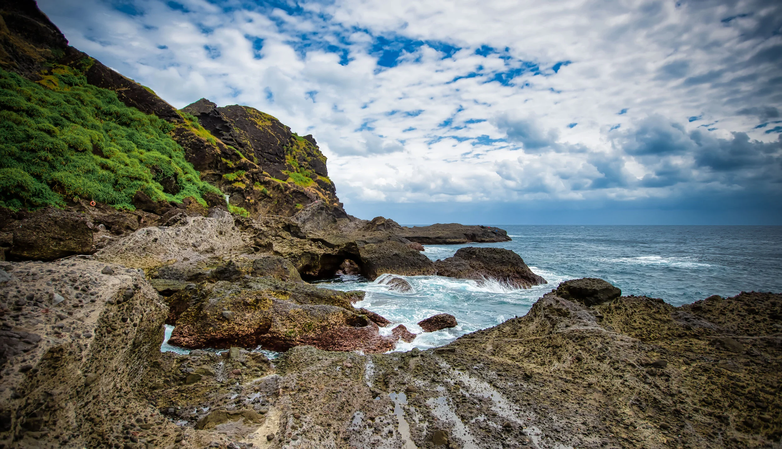
The twenty-two hectare island, which prominently features three large mountain-like rocks is estimated to have formed hundreds of thousands (if not millions) years ago.

Geologists link the creation of the island to the eruption of the now-extinct underwater Duluan Volcano (都巒山層), which also formed much of what we today refer to as the East Rift Valley (花東縱谷). 

Science it seems partially agrees with the Amis legend above in that Sanxiantai wasn’t always an island.

It was at one time connected to the rest of Taiwan as a headland, but thousands of years of sea activity eventually eroded away the low lying strip of land between the two. 

Still, when the tide is out, if you don’t mind getting your feet wet, it’s possible to walk across the coral beach to the island. 

But why would anyone bother when you have such a beautiful bridge to enjoy?

Link: 台灣東部知識單元資料庫 (National Museum of Natural Science)

Currently, the island is well-connected with a network of footpaths that have been constructed allowing visitors the opportunity to hike around the island as well as to its highest point, the Sanxiantai Lighthouse (三仙台燈塔.) 

Apart from simply walking around the island, its important to note Sanxiantai is surrounded by coral reefs and has easily-accessible underwater caves that makes it a haven for tropical fish.

The area has always been a popular spot with local fishers, but recently it has also become popular with divers who come to enjoy one the underwater beauty of the island.

Whatever your preferred type of recreation, Sanxiantai is a geologically diverse island that features sea-eroded caves, rare coastal vegetation, a rocky moon-like surface, beautiful views of the Pacific Ocean and of course a great vantage point to look back at the beauty of Taiwan’s eastern coast. 

Unfortunately as I mentioned above, quite a few people show up to the area to check out the beach and the bridge before heading on to their next destination.

I highly recommend that if you are visiting this area that absolutely must walk across the bridge and take some time to walk around the beautiful island as well. 

Links: Sanxiantai (Taiwan Gods) | Sanxiantai (East Coast National Scenic Area)

Ba-Gong Bridge (跨海八拱橋)

Probably the highlight of most people’s visit to Sanxiantai is the famed bridge that connects the island to the rest of Taiwan. The four-hundred meter long arched bridge has become an iconic image for the east coast and any visit to Taitung would be incomplete without checking it out. 

Often confused with the island itself, the bridge is actually named Ba-Gong Bridge (八拱橋), which quite literally means “Eight-Arch Bridge,” but is a name that gets little mention in English-language literature.  

The construction of the bridge (and the success of Sanxiantai as a tourist attraction today) are the result of the hard work of Mr. Lee Hua-dong (李華棟), who is considered to be the Father of Sanxiantai (三仙台之父). 

With the opening of Sanxiantai as a recreational tourist area after Martial Law (戒嚴時期) was lifted in 1987, the construction of a bridge became essential.

Constructed that same year, the bridge is beautifully designed and was done so in an environmentally friendly way attempting to put as little burden on environment as possible. 

Designed to look like a dragon (possibly a nod to the Amis legend), the blue and red bridge also resembles the powerful ocean waves that the east coast is known for. 

Prior to the construction of the bridge, the only way to actually reach the island was to wade through the water at low-tide or go across in a keep. The latter caused quite a bit of ecological damage to the coral bed, so the presence of the bridge today helps the environment by allowing tourists to walk across to the island, without negatively affecting the coral. 

Although the bridge is four-hundred meters long, walking across it might take a while as it can be quite windy.

And because it’s also a great spot for taking photos!

Getting There


Getting to Sanxiantai should be rather straight-forward. 

It is situated directly along the Number 11 Coastal Highway (台11線) between Hualien and Taitung, which is probably one of the busiest and most identifiable roads on the entire East Coast. 

Unfortunately the island is quite far from both cities, which is why some tourists might run into trouble getting there.

Located around fifty kilometres north of Taitung City and over one-hundred kilometres south of Hualien, if you’ve got a car or a scooter, you shouldn’t have much of a problem, as it is hard to miss.

Address: #74 Jihui Road, Chenggong Township, Taitung. (臺東縣成功鎮三仙里基翬路74號)

GPS: 121.42168/23.126135

If you find yourself on the East Coast without a car or scooter however, you’re going to have to rely on public transportation, which truthfully isn’t all that convenient or reliable. 

Nevertheless, you do have a few options for getting there. 

  • From Hualien Train Station (花蓮車站) take Hualien Bus (花蓮客運) #1145.

  • From Taitung Train Station (台東車站) take Ting-tung Bus (鼎東客運) #8101, #8101A or #8102.

No matter what direction you’re coming from, make sure to get off at the Sanxiantai Bus Stop (三仙台站)

If you elect to take the bus option, I highly recommend you pay very close attention to the time tables linked above for each of the buses as they don’t come all that frequently.

If you’d prefer not to take a bus and waste time waiting around, there is also the option of booking a taxi for the day that will take you to Sanxiantai and some other locations for a set price.  

The Taitung County Government Tourist Bureau has a list of ‘trustworthy’ drivers that are available for booking, which I’ve linked below. This method might be a bit more expensive, but if you’re traveling with friends or family, it might be a more convenient option. 

Link: Taitung Taxi Tour Drivers (Taitung Tourism) 

Even though Sanxiantai is a bit of a distance from Taitung City, it is still one of those tourist destinations that you absolutely have to visit when you’re on the East Coast. 

With this one I don’t feel like I have to do too much pushing as the iconic bridge has become an iconic image used to promote Taiwan to the rest of the world. 

Unfortunately, if you hadn’t already noticed, the weather on the day I visited was pretty awful.

So, don’t be surprised if you see this space updated sometime in the future with prettier photos.


Goðafoss

While traveling around Iceland’s ‘Diamond Circle’, one of the last major stops before heading back to Reykjavik is the beautiful northern port city of Akureyri - Known as Iceland’s “Northern Capital” the city was a welcome respite after countless hours of driving through northern Iceland.

Coincidentally we happened to be travelling through Iceland at the same time as when the 2018 World Cup was being held and the Icelandic national team had earned a spot for the first time in its history. It was somewhat of a cultural thing for me as I’m from Canada and the whole football / soccer thing never really interested me. I find its to be a far too dramatic sport. The collective attention of the Icelandic people however was focused solely on the World Cup.

We knew that Iceland had a relatively small population, especially compared to what we’re used to living in Taiwan, but when almost half of the country had packed up and left for Russia, the small town of almost 20,000 seemed eerily empty.

Nevertheless Akureyri is a picturesque harbour-side city surrounded by mountains and the ocean and compared to the capital, has a much better system of urban planning, which means getting around is a lot less confusing for tourists.

Our accommodations in town were stunning and included a geothermal jacuzzi which was much appreciated after driving hundreds of kilometres from the rather desolate area where we stayed near Dettifoss.

Another highlight was having access to a nice supermarket where we picked up some fresh juice, Icelandic craft beer, fresh bread and more supplies for the road.

Due to time constraints we hadn’t planned many stops for the last leg of our trip between Akureyri and Reykjavik, so just before arriving in Akureyri we more or less made our final stop along the Diamond Circle at yet another waterfall, but not just any waterfall - The Waterfall of the Gods.

With a name like that, who wouldn’t want to stop and check it out?

Godafoss

Goðafoss as it is known locally just so happens to be one of the most spectacular and well-known waterfalls in Iceland. Even though it is not as large, wide or powerful as all of the others it is certainly one of the most beautiful and that is true for every season.

There’s a reason why the waterfall is known as the “Waterfall of the Gods” but before I get into that I think I should talk about its physical attributes:

Godafoss is a 12 meter high, 30 meter wide set of cascading falls, similar to Canada’s Niagara Falls.

The water flows from the river Skjálfandafljót, one of Iceland’s longest rivers. Originating from the Vatnajökull Glacier, the river also happens to be the water source for several other waterfalls including Hrafnabjargafoss, Aldeyjarfoss, Barnafoss and Ullarfoss.

During the summer the area around the waterfall is lush with green grass which reflects in the colour of the water. In the winter the area is usually covered in snow, the falls may freeze and if you’re lucky you can see the Aurora Borealis in the night sky.

The waterfall is attractive year round and when I visited it was really beautiful.

However I would have loved to have the opportunity to watch the Northern Lights at the same time.

So how does it get its name?

Well, like a lot of things in Iceland, it has to do with a bit of a legend. Whether or not the story is true is up for debate, but in Iceland it is widely accepted as fact as it is chronicled in the Íslendingabók (Book of Icelanders), a 12th Century work that tells the early history of human settlement in Iceland.

The first people to settle in Iceland were Norwegian explorers, more commonly known as the Vikings. When they settled on the island they brought with them their culture and their old Norse religion which consisted of deities like Thor, Odin, Loki, etc.

No, not the superheroes that you’ve seen in the movies.

As Christianity spread throughout Europe, societies that practiced what was considered “pagan” religions were often forcibly converted. The Christianity of a thousand years ago was much different than it is today, no one bothered with slogans like “God is Love” to convert people - The good word was spread primarily by the sword.

By the time the Icelandic Commonwealth was established in 930AD, pressure to make Christianity the official state religion became an issue as Norway threatened to invade if the people of Iceland didn’t conform.

Around the year 1000AD, when the annual meeting of the parliament met at Þingvellir, it was decided that for the good of the people, Christianity would become the state religion with the caveat that pagans could still practice in private.

That decision was placed on the shoulders of an “Ásatrú” priest (or goði) named Thorgeir Ljosvetningagodi Thorkelsson who was said to have spent days meditating and praying to the Old Gods before it was clear what path would be taken. When the decision was made to make Christianity the official state religion Thorkelsson returned home to the north of Iceland where he tossed his idols of the Norse Gods into a beautiful waterfall.

Since then that waterfall has been named Goðafoss.

Photography

Like most other destinations in Iceland there are a few things you’ll want to take into consideration if you’re planning on visiting and taking photos at this waterfall.

Similar to Dettifoss, the last waterfall you’re likely to have seen before this one, there are two different sides to view Godafoss from. In this case however getting to either side doesn’t take an much time - You’ll just have to get in your car, cross a bridge and park at another parking lot to enjoy the view from the other bank.

Unfortunately due to the amount of people that visit, you’ll probably want to find a spot to set up your tripod away from the wooden platform - The problem with the platform is that when people walk it creates a shake which will ruin your long exposure shots.

To solve this problem you can walk a bit further past the waterfall onto the grass bank for a bit more stability. Likewise you could also consider taking the path down to water level.

If you do take the path down to water level though, you’ll be confronted with a whole new set of issues with the amount of spray and mist that will cloud up your lens. In this case you’ll need to bring something to safely wipe down your lens with between shots.

Most of the shots I’m sharing here today were taken on an overcast and somewhat dreary day with a wide-angle lens and an ND filter attached. The shots are a range of long exposures that are anywhere between 2-10 seconds each.

If you don’t have an ND Filter on-hand it is important that you know how to manually control your camera if you’re looking to take photos similar to these. You may be able to get up to around one second exposures if the light is right.

To do this you’ll want to ensure that your ISO is as low as possible. Preferably at ISO 100. You’ll also want to have your exposure set to -1 or -2 so that your shot won’t be blown out.

Take some test shots and play with the settings to find out what’s best and then have fun!

If you visit during the summer and want long exposure shots like the ones here, I highly recommend investing in a Natural Density filter for your lens. However if you visit during the winter when there isn’t much light, you could get away without one.

If you visit in winter you’re going to be in luck because it’s likely that you’ll have the added bonus of the Northern Lights overhead. You won’t need lens filters for taking photos of the waterfall and the Northern Lights, but you’re definitely going to need a tripod, a remote control (or cable shutter release) and a lens capable of f/2.8 apertures.

For a handy introduction on how to shoot the Northern Lights click this link - Northern Lights Photography Settings

Getting There


Godafoss is located in northern Iceland along the Ring Road that circles the country.

Situated along the ‘Diamond Circle’ sightseeing route it is about a 53 kilometre (45 minute) drive from the northern city of Akureyri.

If you’ve first travelled south along the Diamond Circle and made your way north, the waterfall is about a 50km drive west of Lake Mývatn or the town of Húsavík.

In both cases you will drive along Road N.1 which is the highway that circles the country. The waterfall is a simple stop along the road and there will be adequate signage on both sides that notify travellers that you’re approaching the falls.

If you’ve decided that you’re not going to bother renting a car while visiting Iceland, you’re going to have to rely on public transportation or tour groups to get to where you want to go. There are tours out of the capital offered by tour groups like Reykjavik Excursions or Arctic Adventures which offer tourists access to several different destinations. It is important to remember that if you want to book a tour that you should do so well in advance as the seats on the daily tours tend to fill up quickly.

There are public buses that run between Akureyri, Myvatn and Egilsstadir that you may want to consider but you should know in advance that these buses don’t come that often, so you may get stuck waiting around for quite a while which is probably not the wisest way to use your time in Iceland. 

Bus Link: SBA-Norðurleid route 62 and 62A.

As one of the highlights of any travellers trip through Northern Iceland, Godafoss is one of those must-visit locations when you’re in the area. The waterfall is beautiful all year long but even though it is one of Iceland’s most popular destinations, it is rarely packed with people. If you visit, make sure to check out both sides of the fall and enjoy the beautiful scenery. Likewise if you are in Iceland during the winter months, try to visit a bit later at night so that you can not only enjoy the waterfall but the beautiful Northern Lights as well.


Reynisfjara (Black Sand Beach)

For most travellers, a white sand beach vacation is just what the doctor ordered after a long and stressful year of work. Travel Agencies all over the world offer attractive vacation packages that allow weary travellers to simply hop on a plane and be transported to a beautiful beach resort - where all they have to do is lay around, eat, drink and relax.

Having visited the beautiful beaches of Boracay, Bali and Palau (among others), I can certainly attest that this style of vacation helps to recharge the soul and even though its not the sort of trip that I typically prefer to go on, I can certainly understand why people are so fond of them.

If you’re looking to relax on a beach its unlikely that Iceland is going to be on the top of your list of destinations - The small island nation in the North Atlantic isn’t exactly known for its beach-resorts.

Instead it is a nature lovers paradise where visitors spend their precious vacation time time in awe of giant glaciers, steaming volcanoes, massive waterfalls and the spectacular Aurora Borealis.

Nicknamed the ‘Land of Ice and Fire’, the country is known more for its geo-thermal hot springs and spas than it is for beaches, but you might be surprised to learn that Iceland is home to one of the top-ten (non tropical) beaches in the world!

Just don’t expect to go for a swim.

Southern Iceland’s ‘Black Sand Beach’, known to locals as Reynisfjara is one of the country’s top attractions and for good reason - It is one of the prettiest beaches you’ll ever have the luck of visiting.

Black Sand?

Why is the sand at Reynisfjara ‘black’ while most of the worlds other beaches have either golden, brown or white sand?

Well, thats actually quite simple to explain.

The beach is located near the very active Katla Volcano. The lava from each of its eruptions flowed down from the mountain eventually reaching the coast. This allowed for the formation of basalt rocks when the lava met with the frigid temperatures of the North Atlantic.

With each of Katla’s eruptions, the topography in the region changed and the land area also expanded - so much that thousands of years ago this beach didn’t even exist.

The “sand” that you’ll find on the beach is actually more similar to fine rocks and pebbles than the finely grained sand that you are used to on other beaches.

The supply of this special black sand howeveris constantly being replenished thanks to the volatility of Katla which is in a constant state of activity.

The Reynisdrangar Basalt Columns and Folklore

For travellers, the beach is highly regarded as one of the most beautiful in the world - Locals on the other hand hold Reynisfjara in high regard not only for its beauty but for some supernatural events that (they’re convinced to have) occurred there once upon a time.

Local folklore tells of two different stories that attempt to explain why the beach looks the way it does with the beautiful basalt columns at the far end.

Icelanders debate about which myth is the most accurate but everyone agrees that the common feature of both is that trolls were most definitely involved.

If you’re unaware, trolls are basically the bane of every Icelanders existence.

These trolls, unlike their internet counterparts however are quite dangerous.

The first legend tells of a husband whose beloved wife was kidnapped and murdered by two of these dangerous trolls.

The husband, seeking vengeance pursued the trolls to Reynisfjara and somehow froze them as they attempted to escape to sea.

How he froze them, I can’t really tell you but I’d like to think that it was by the power of love.

The second legend tells of a group of trolls who lived in the caves on the beach and terrorized ships that passed by.

The trolls were not only greedy but a bit daft, so one day when they went out to sea to attack a ship they lost track of time.

When the sun came up, they were turned to stone on the spot - unfortunately the ship and the people on it were turned to stone as well.

Link: Folklore in Iceland  

In actuality the ‘Reynisdrangar basalt columns’ were not formed by the nefarious activity of trolls but are naturally occurring and were at one time connected to Reynisfjall mountain.

Thousands of years of weathering and sea erosion has submerged part of the mountain making the columns seem as if they are disconnected from the mountain by a patch of ocean.

Reynisfjall Mountain and Hálsanefshellir Cave

Reynisfjall Mountain, which is located next to the beach is a 340 meter (1115 ft) tall mountain that is at least five kilometres in length and about 800 meters wide.

The mountain is most well-known for its pyramid-shaped cliff of basalt columns which look like they were sculpted by hand rather than by the work of Mother Nature.

The columnar joints on the side of the mountain, known to locals as ‘Garðar’ are one of the most popular locations for taking selfies in Iceland and were even featured in an episode of the Game of Thrones.

You aren’t likely to find trolls making their homes in the mountain, but it is important to note that the mountain is a nesting ground for various species of seabirds. Depending on the season you might see fulmars, guillemots and if you’re lucky some puffins!

On the beach you are bound to come across the beautiful ‘Hálsanefshellir Cave’ which is just a small cavern in the mountain.

The interior of the cave looks a bit like the basalt columns on the outside and is a great place to escape when the winds get too high and you’re feeling cold.

Be careful not to stay in the cave for too long though, you could get trapped inside during high tide!

Tips and Safety Considerations

 There are some important things that you’re going to want to keep in mind while visiting.

You’ll likely notice a warning sign before you’re able to walk onto the beach. Pay close attention to all of the warnings.

This isn’t a place where you’re going to want to have an unfortunate accident.

  • You can’t swim at this beach. Even if the frigid water doesn’t bother you, the water is extremely dangerous and there have been quite a few unfortunate accidents in recent years.

  • You may feel like you are standing a safe distance away from the water, but the ‘sleeper waves’ at this beach are as sneaky as they are dangerous. Stay at least thirty meters from the water and make sure that you are constantly aware of your surroundings. Don’t turn your back to the ocean.

  • Some travellers may think that its okay to get close to the water but something most people don’t ever consider is that when the waves pull back into the ocean they pull back with even greater force. This means that’s the water will drag out even the strongest of us. If you get pulled out with the water its not likely anyone will ever see you again.

  • If you are travelling with children, make sure to keep an eye on them at all times.

  • There is no one on duty, no lifeguards, no security guards, no tourism officials. You’re on your own if something unfortunate happens!

  • There is a small cafe next to the parking lot. Parking is free but if you want to use the restroom you’re going to have to pay a small fee to get in.

  • The food in the cafe is quite expensive, so you’ll probably want to have a lunch packed.

  • Make sure to pack a down jacket as it tends to be very cold and extremely windy on the beach. Likewise you’re going to need sturdy footwear to walk on the beach.


The beach, which is located near the country’s southernmost village Vík í Mýrdal is about 180 km (110 mi) from the capital of Reykjavik.

If you are driving from the capital you can expect about a 2.5 hour drive along the Ring Road.

There is lots of signage along the way, so its not likely that you’ll need to use GPS to find your way.

If you’ve decided that you won’t bother renting a car while visiting Iceland, you’re going to have to rely on public transportation to get to the waterfall. There are tours out of the capital offered by tour groups like Reykjavik Excursions which offer tourists access to several different stops for around $100USD. It is important to remember that if you want to book a tour that you should do so well in advance as the seats on the daily tours tend to fill up quickly.

If you are visiting the beach you’ll also want to visit other attractions like Skogafoss, Seljalandsfoss, the Dyrhólaey Lighhouse and Kirkjufjara Beach which are all a short distance away from the beach and the small village of Vik.