Photo Post

St. Paul's Cathedral

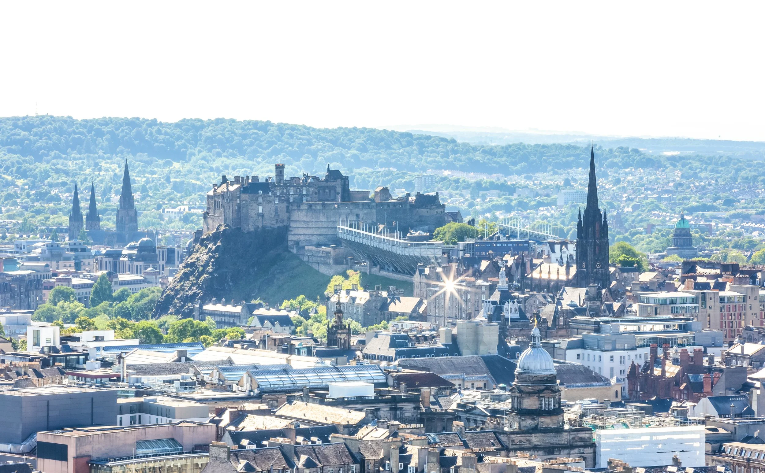
St Paul’s Cathedral is easily one of the most well-known and also most recognizable sights in the historic city of London and for almost three hundred years it dominated the city’s skyline as the city’s tallest structure.

With a history dating back more than fourteen centuries, the cathedral has played a significant role in British history and has become an important symbol with regard to the national identity of the English people.

St. Paul’s is not only home to the seat of the Bishop of London and is the mother church of the diocese of London but (similar to Westminster Abbey) often finds itself as the host of some of England’s most important events.

Some of which have in recent years included royal weddings and the funerals of important figures like Sir Winston Churchill and former Prime Minister Margaret Thatcher.

Even though St. Paul’s time as being the tallest building in the city is clearly over, it is said that the majority of the visitors who visit the popular observation deck of the nearby Shard skyscraper spend most of their time taking photos of the beautiful cathedral which is located just across the Thames.

Today the cathedral serves not only as a fully functional church that holds daily services but also as one of London’s most popular tourist attractions with more than two million people visiting each year.

History

St. Paul’s Cathedral has a history that dates back to AD 604 but don’t let that history fool you, the cathedral that we can see today is no where near that old. Historical records indicate that a church was built somewhere on the site over fourteen hundred years ago, but there is actually little evidence to prove such claims.

The cathedral known as “Old St. Paul’s” was constructed on site by the Normans between 1087 and 1240 and was a mixture of Romanesque and Gothic architectural styles constructed using both stone and wood.

London however has had a bit of bad luck when it comes to fire and the city has been ravaged on more than a few occasions, the most well-known of which is probably the Great Fire of 1666.

The devastating fire destroyed 13,200 houses, 88 parish churches and forced the displacement of around 70-80,000 of the city’s inhabitants. Most notably the original St. Paul’s Cathedral, which was then one of London’s largest and most important buildings was also destroyed.

While Londoners went about rebuilding their lives, the office of famed British architect Sir Christopher Wren was selected and given the honour of overseeing the design and construction of over fifty churches to replace those that were destroyed, including that of St. Paul’s Cathedral.

The name Sir Christopher Wren may not be a household name for a lot of people outside of England, but the man was a legendary genius who was not only England’s most highly acclaimed architects but was also an anatomist, astronomer, geometry and mathematician-physicist.

While its often overlooked, Wren had a tremendous influence on intellectual affairs in 17th and 18th century Britain as President of the Royal Society making tremendous contributions to scientific thought and discovery.

Today he is most well-known for having a hand in the design and construction of some of London’s most well-known buildings with his work on St. Paul’s Cathedral being considered the masterpiece of his architectural genius.

In 1668 the Archbishop of Canterbury, with support from the Bishops of London and Oxford charged Wren with the responsibility of designing a new cathedral to replace the old St. Paul’s Cathedral.

Wren was given the instructions that the new cathedral should be “handsome and noble to all ends of it and to the reputation of the city and the nation” meaning that whatever he came up with had to be so grand in design that nothing else could compare.

Construction on the cathedral started in the summer of 1675 and was opened to the public twenty-two years later in 1697.

The finished version of Wren’s St. Paul’s Cathedral would be the tallest building in London, the second largest church in Britain and had a dome that was considered the finest in the whole world.

The building, which was financed by a tax on coal cost £1,095,556, which is equivalent to around $200 million US dollars today.

During the Second World War the cathedral was damaged during the German Blitz of London but was saved from outright destruction due to the efforts of civil defence brigades to protect it.

Churchill believed that the destruction of the cathedral would do irreparable damage to the morale of the nation, so he ensured that every effort was made to protect it from harm.

Still, one of the most iconic images of the Blitz depicts the dome of the cathedral shrouded in smoke with the buildings in the foreground engulfed in flames.

The image was thought to describe the resolve of the British people which was “proud”, “glorious” and “indomitable” and helped to push the British and the allies to ultimate victory over the Germans.

Sir Christopher Wren passed away in 1723, a few years after the completion of the cathedral.

It was only fitting that his tomb be constructed in the crypts of his architectural masterpiece. Today people can not only visit the church but pay their respects to one of English history’s greatest figures.

The inscription on his tomb reads: “Lector, si monumentum requiris, circumspice” or “Reader, if you seek his memorial, look around you” which is a fitting tribute to the man and his accomplishments.

Design

When Christopher Wren was charged with the design and construction of a new St. Paul’s Cathedral, his office was already busy designing and constructing fifty other parish churches.

Designing a new version of St. Paul’s however was a project unlike any of the others - Wren’s task was to create a cathedral more grand than the original as well as a building that would serve as a landmark.

He also had to satisfy the stringent requirements of the Church of England, rich benefactors and try to stay true to and respect the mediaeval traditions of English church building.

Wren came up with five different designs for the cathedral which were inspired by the design of St. Peter’s Basilica in the Vatican and a combination of English medieval architecture with contemporary Renaissance trends - most notably the Baroque style.

The design that was approved combined neoclassical, gothic and baroque elements which symbolized the ideals of the English restoration with the construction techniques of the time.

Wren was given artistic licence to make minor changes during construction which he used to make modifications based on elements of some of the other designs he had submitted.

The finished cathedral actually ended up being considerably different than originally planned.

As for the specifics of the architectural design, I’m admittedly not an expert, so for a more in-depth description of the design of the interior and exterior of the cathedral, I recommend checking out the links below.

St. Paul’s Cathedral (Wiki)

Designing St. Paul’s Cathedral (Google Arts & Culture)

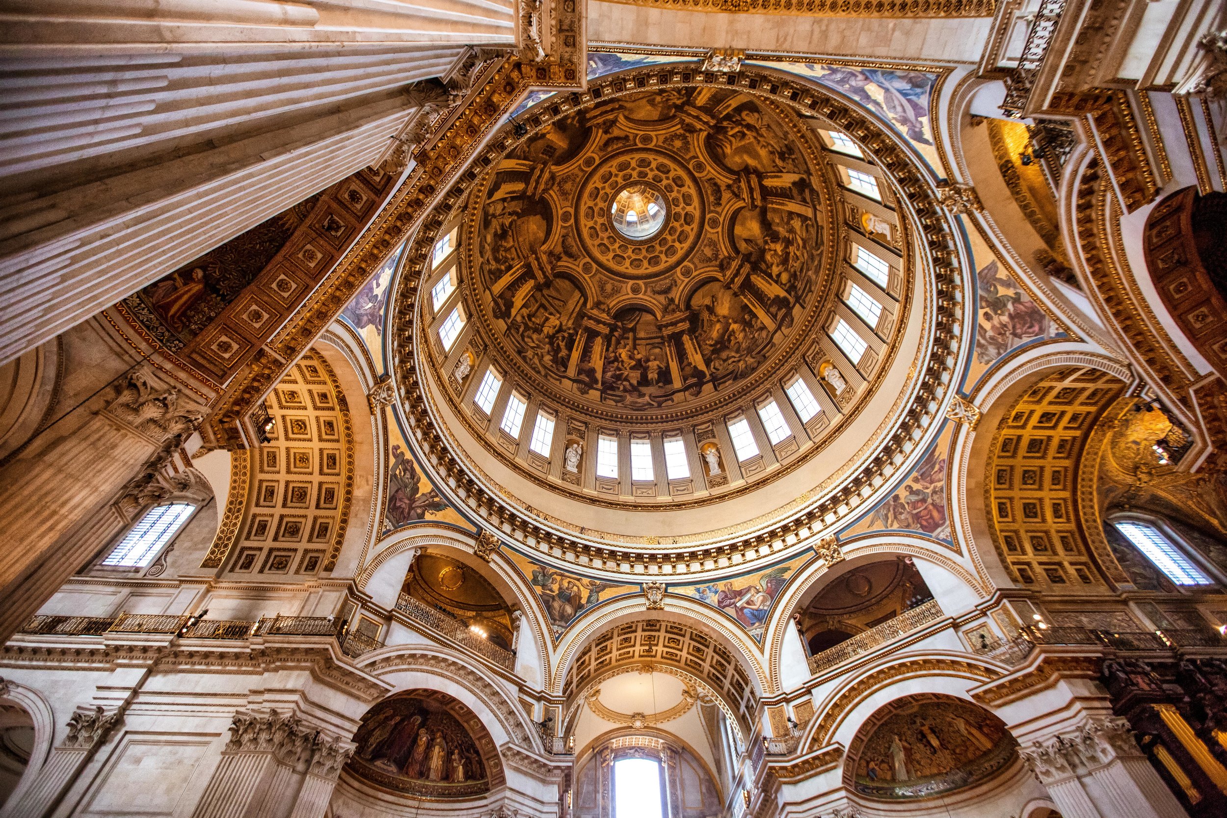
What I will go into a bit of detail about with regards to design is that of the dome - Which is said to be one of the finest in the world.

I’ve been lucky enough to visit the dome’s at both St. Peter’s Basilica in the Vatican and St. Paul’s in London and can easily say that St. Paul’s is the clear winner in terms of beauty.

When you stand under the dome looking up, the beauty of Wren’s design will captivate anyone who sees it. If you then climb to the base of the dome on the roof and gaze at the floor below, you’ll be even more amazed.

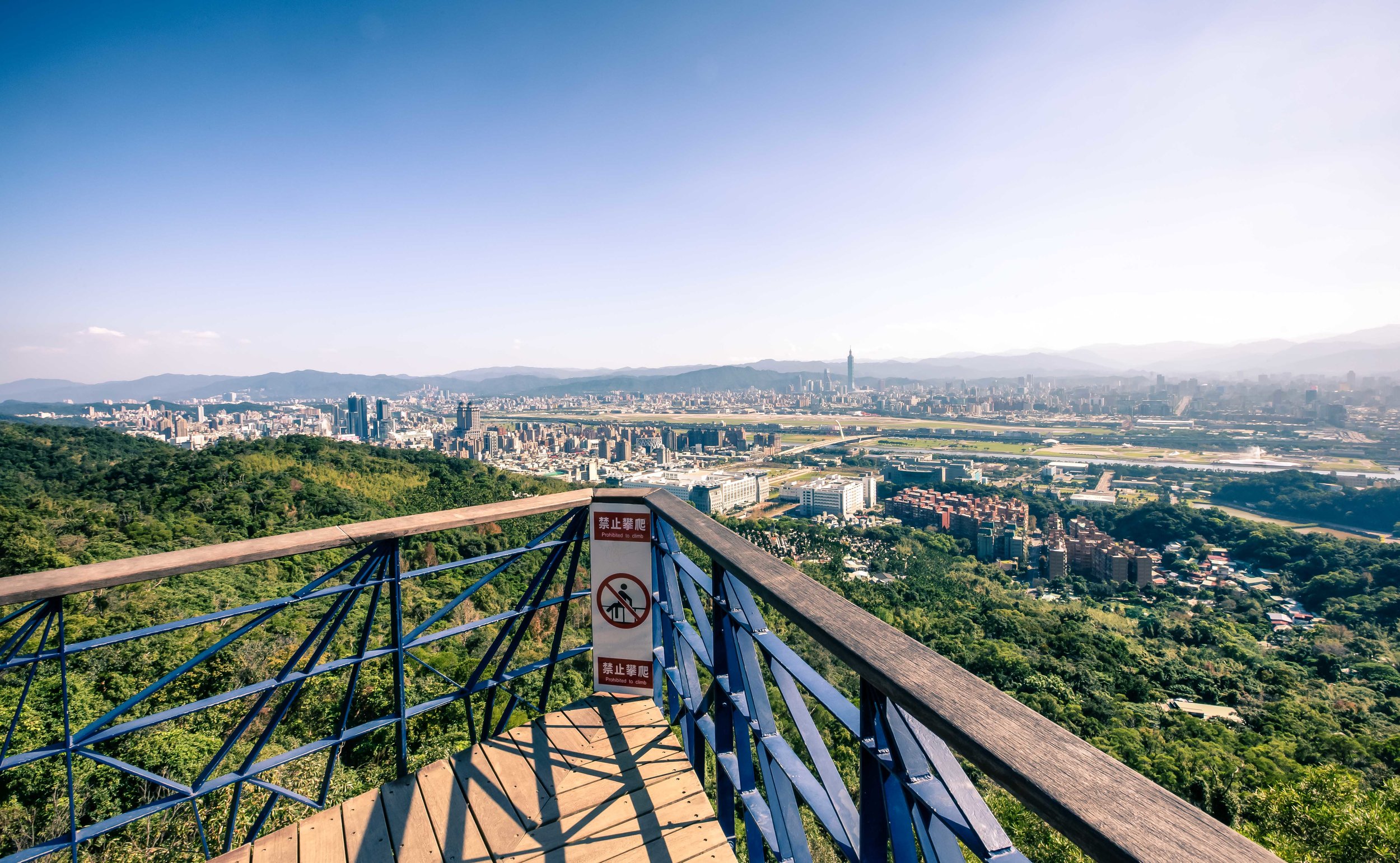
Oh, and I suppose the beautiful views of the London cityscape from the top of the dome aren’t too shabby as well!

The dome is composed of three different shells - The outer dome, a concealed brick cone (for structural support) and an inner dome. The main internal space of the cathedral is located under the central dome which is supported from floor-level by pendentives that rise up in the form of eight arches that surround the dome.

The genius of Wren’s design supports the dome from ground level while leaving the area under it completely open with no visible supports. The dome, which is said to weigh over 850 tons was also designed in a way that its weight is supported and lightened through the three shells.

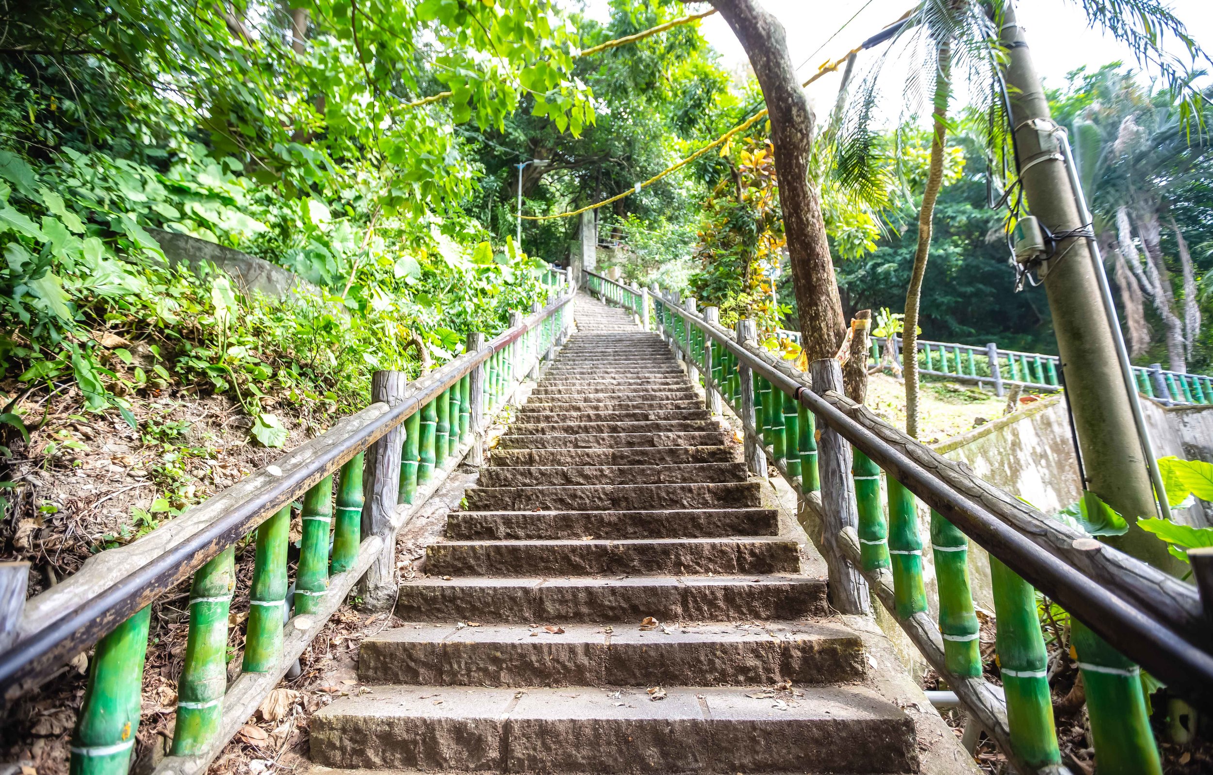
You’re not supposed to take photos in the cathedral, but it would be a shame to go to such a beautiful place and not sneak a few. I took a few from floor level, a few from the first platform and of course more from the outside viewing platform.

Visiting the dome makes the price of admission fee well worth the trip and is probably going to be the highlight of your day if you visit.

Getting There / Visiting

Like Westminster Abbey, St. Paul’s Cathedral is one of London’s most popular tourist attractions.

A visit to St. Paul’s however is a bit more relaxing as guests are able to enjoy the spectacular interior and exterior of the building with a little more freedom.

In addition to checking out the historic building, guests are also able to climb to the different levels of the dome which on the inside gives amazing views of the cathedral’s interior and its architecture while the higher exterior level allows for spectacular panoramic views of the city.

To gain entry to the cathedral you will have to purchase a ticket which you can either buy online or when you arrive.

If you want to save a bit of time and money I recommend purchasing your tickets online so that you don’t end up waiting in a long line. If you decide to purchase your ticket when you arrive the general admission costs £18 for adults (tickets are cheaper for students, children and seniors).

Link: St. Paul’s Cathedral - Tickets

The cathedral is open for sightseeing from Monday to Saturday from 8:30am - 4:30pm and it should be noted that most people spend more than two hours on their visit, so make sure to arrive a bit early in the day.

You should also be aware that before you gain entry to the cathedral that you’ll have to pass through an airport style security check where guards will be checking bags.

If you want to ensure that you pass through quickly, try not to carry too much with you. They won’t let you in with anything larger than a backpack and there aren’t any lockers available to store your things.

It’s also important to note that photography and the usage of tripods within the cathedral is prohibited, so you probably won’t want to bother bringing too much gear with you if you’re a photographer.

Make sure to bring a camera though because the views from the top of the dome are amazing!


St. Paul's Churchyard, London EC4M 8AD, United Kingdom

There are a number of public transport options that will get you to the cathedral:

If you are using the London Underground, it is only a two minute walk from St. Paul’s Station but you can also easily walk there in under five minutes rom Mansion House, Blackfriars or Bank stations.

If you are taking the bus you can get to the cathedral via routes 4, 8, 11, 15, 17, 23, 25, 26, 56, 100, 172, 242 and 521.

If you are travelling by train City Thameslink, Cannon Street and Liverpool Street stations are a short walk away.

In retrospect, my visit to England was a learning experience in the legend that is Wren - I visited several of the buildings that he designed as well as his former home and the trip culminated in a visit to St. Paul’s Cathedral, his masterpiece and his final resting place.

None of this was actually intended, but my trip was made even better because of it.

I enjoyed visiting Westminster Abbey, but can honestly say that if I were to choose between the two for a second visit, without a second thought I’d be visiting St. Paul’s Cathedral again.

If you are visiting London, this is a destination that you’re not going to want to miss.


Reynisfjara (Black Sand Beach)

For most travellers, a white sand beach vacation is just what the doctor ordered after a long and stressful year of work. Travel Agencies all over the world offer attractive vacation packages that allow weary travellers to simply hop on a plane and be transported to a beautiful beach resort - where all they have to do is lay around, eat, drink and relax.

Having visited the beautiful beaches of Boracay, Bali and Palau (among others), I can certainly attest that this style of vacation helps to recharge the soul and even though its not the sort of trip that I typically prefer to go on, I can certainly understand why people are so fond of them.

If you’re looking to relax on a beach its unlikely that Iceland is going to be on the top of your list of destinations - The small island nation in the North Atlantic isn’t exactly known for its beach-resorts.

Instead it is a nature lovers paradise where visitors spend their precious vacation time time in awe of giant glaciers, steaming volcanoes, massive waterfalls and the spectacular Aurora Borealis.

Nicknamed the ‘Land of Ice and Fire’, the country is known more for its geo-thermal hot springs and spas than it is for beaches, but you might be surprised to learn that Iceland is home to one of the top-ten (non tropical) beaches in the world!

Just don’t expect to go for a swim.

Southern Iceland’s ‘Black Sand Beach’, known to locals as Reynisfjara is one of the country’s top attractions and for good reason - It is one of the prettiest beaches you’ll ever have the luck of visiting.

Black Sand?

Why is the sand at Reynisfjara ‘black’ while most of the worlds other beaches have either golden, brown or white sand?

Well, thats actually quite simple to explain.

The beach is located near the very active Katla Volcano. The lava from each of its eruptions flowed down from the mountain eventually reaching the coast. This allowed for the formation of basalt rocks when the lava met with the frigid temperatures of the North Atlantic.

With each of Katla’s eruptions, the topography in the region changed and the land area also expanded - so much that thousands of years ago this beach didn’t even exist.

The “sand” that you’ll find on the beach is actually more similar to fine rocks and pebbles than the finely grained sand that you are used to on other beaches.

The supply of this special black sand howeveris constantly being replenished thanks to the volatility of Katla which is in a constant state of activity.

The Reynisdrangar Basalt Columns and Folklore

For travellers, the beach is highly regarded as one of the most beautiful in the world - Locals on the other hand hold Reynisfjara in high regard not only for its beauty but for some supernatural events that (they’re convinced to have) occurred there once upon a time.

Local folklore tells of two different stories that attempt to explain why the beach looks the way it does with the beautiful basalt columns at the far end.

Icelanders debate about which myth is the most accurate but everyone agrees that the common feature of both is that trolls were most definitely involved.

If you’re unaware, trolls are basically the bane of every Icelanders existence.

These trolls, unlike their internet counterparts however are quite dangerous.

The first legend tells of a husband whose beloved wife was kidnapped and murdered by two of these dangerous trolls.

The husband, seeking vengeance pursued the trolls to Reynisfjara and somehow froze them as they attempted to escape to sea.

How he froze them, I can’t really tell you but I’d like to think that it was by the power of love.

The second legend tells of a group of trolls who lived in the caves on the beach and terrorized ships that passed by.

The trolls were not only greedy but a bit daft, so one day when they went out to sea to attack a ship they lost track of time.

When the sun came up, they were turned to stone on the spot - unfortunately the ship and the people on it were turned to stone as well.

Link: Folklore in Iceland  

In actuality the ‘Reynisdrangar basalt columns’ were not formed by the nefarious activity of trolls but are naturally occurring and were at one time connected to Reynisfjall mountain.

Thousands of years of weathering and sea erosion has submerged part of the mountain making the columns seem as if they are disconnected from the mountain by a patch of ocean.

Reynisfjall Mountain and Hálsanefshellir Cave

Reynisfjall Mountain, which is located next to the beach is a 340 meter (1115 ft) tall mountain that is at least five kilometres in length and about 800 meters wide.

The mountain is most well-known for its pyramid-shaped cliff of basalt columns which look like they were sculpted by hand rather than by the work of Mother Nature.

The columnar joints on the side of the mountain, known to locals as ‘Garðar’ are one of the most popular locations for taking selfies in Iceland and were even featured in an episode of the Game of Thrones.

You aren’t likely to find trolls making their homes in the mountain, but it is important to note that the mountain is a nesting ground for various species of seabirds. Depending on the season you might see fulmars, guillemots and if you’re lucky some puffins!

On the beach you are bound to come across the beautiful ‘Hálsanefshellir Cave’ which is just a small cavern in the mountain.

The interior of the cave looks a bit like the basalt columns on the outside and is a great place to escape when the winds get too high and you’re feeling cold.

Be careful not to stay in the cave for too long though, you could get trapped inside during high tide!

Tips and Safety Considerations

 There are some important things that you’re going to want to keep in mind while visiting.

You’ll likely notice a warning sign before you’re able to walk onto the beach. Pay close attention to all of the warnings.

This isn’t a place where you’re going to want to have an unfortunate accident.

  • You can’t swim at this beach. Even if the frigid water doesn’t bother you, the water is extremely dangerous and there have been quite a few unfortunate accidents in recent years.

  • You may feel like you are standing a safe distance away from the water, but the ‘sleeper waves’ at this beach are as sneaky as they are dangerous. Stay at least thirty meters from the water and make sure that you are constantly aware of your surroundings. Don’t turn your back to the ocean.

  • Some travellers may think that its okay to get close to the water but something most people don’t ever consider is that when the waves pull back into the ocean they pull back with even greater force. This means that’s the water will drag out even the strongest of us. If you get pulled out with the water its not likely anyone will ever see you again.

  • If you are travelling with children, make sure to keep an eye on them at all times.

  • There is no one on duty, no lifeguards, no security guards, no tourism officials. You’re on your own if something unfortunate happens!

  • There is a small cafe next to the parking lot. Parking is free but if you want to use the restroom you’re going to have to pay a small fee to get in.

  • The food in the cafe is quite expensive, so you’ll probably want to have a lunch packed.

  • Make sure to pack a down jacket as it tends to be very cold and extremely windy on the beach. Likewise you’re going to need sturdy footwear to walk on the beach.


The beach, which is located near the country’s southernmost village Vík í Mýrdal is about 180 km (110 mi) from the capital of Reykjavik.

If you are driving from the capital you can expect about a 2.5 hour drive along the Ring Road.

There is lots of signage along the way, so its not likely that you’ll need to use GPS to find your way.

If you’ve decided that you won’t bother renting a car while visiting Iceland, you’re going to have to rely on public transportation to get to the waterfall. There are tours out of the capital offered by tour groups like Reykjavik Excursions which offer tourists access to several different stops for around $100USD. It is important to remember that if you want to book a tour that you should do so well in advance as the seats on the daily tours tend to fill up quickly.

If you are visiting the beach you’ll also want to visit other attractions like Skogafoss, Seljalandsfoss, the Dyrhólaey Lighhouse and Kirkjufjara Beach which are all a short distance away from the beach and the small village of Vik.


Jiantan Mountain (劍潭山)

Taipei is a city that is blessed to be nestled in a space that is almost completely surrounded by mountains.

The city’s mountains not only help determine its comfortable climate but also protect it from the disastrous typhoons that often blow in from the Pacific Ocean.

While the mountains serve an important role for the natural environment, in the eyes of its residents the most important role the mountains play might be to provide spaces for recreation and weekend getaways!

Taipei’s mountains are often filled up with locals wanting to escape the city for a bit of exercise and to spend a bit of time enjoying the beautiful natural environment.

The city government has done an amazing job over the years developing and maintaining countless hiking routes throughout many of its mountainous areas - All of which offer residents a safe place to hike without ever having to worry about getting lost.

If you are a visitor in Taipei there are a multitude of options to choose from when you are looking for a place to enjoy the natural environment.

Guide books and travel blogs often point tourists to the same few destinations - most notably Xinyi District’s “Elephant Mountain” (象山) for the views of the city - But that means your hiking experience is likely to be one that is shared with hundreds, if not thousands of other people and when you have to compete with others for a selfie on a mountain, you’re probably not really able to properly enjoy nature.

What most tourists may not realize is that there are several trails around the city which offer similar or equally impressive views without having to wait in line to take a photo.

One of those hikes that offers such a perspective is a trail on the northern side of the Keelung River that in recent years has become a popular alternative for photographers and instagrammers wanting to avoid large crowds and a bit of fresh air.

Jiantan Mountain (劍潭山)

Most travellers who come to Taiwan are likely to be familiar with the Jiantan MRT Station (劍潭捷運站) as it is home to the Shilin Night Market (士林夜市), one of Taipei’s most well-known tourist stops.

It isn’t likely though that they’re aware that the station gets its name from the mountain that runs parallel to the station and is located on the opposite side of the night market.

Jiantan Mountain isn’t exactly what you’d consider a ‘high’ mountain - it’s only 153 meters above sea level - it is however a historically important one.

Today the mountain is home to the Grand Hotel (圓山大飯店) and numerous temples and recreation areas that were constructed over the past few decades.

During the Japanese Colonial Era, it was home to the Taiwan Grand Shrine (台灣神宮), the highest ranking Shinto Shrine (神社) in the country, but has unfortunately since been destroyed.

It is also home to the Water God Shinto Shrine (圓山水神社) which you can fortunately still see today.

When sovereignty of Taiwan was ‘relinquished’ to the Republic of China at the end of the Second World War the mountain became a military-controlled area in order to protect President Chiang Kai-Shek and his family who were staying in the Grand Hotel until their formal residence was completed.

Once the residence was completed the mountain continued to remain off-limits to the public as it was constructed at the base on the opposite side of the hotel and it was suspected that communists were roaming the areas attempting to assassinate the first family.

It is widely reported that there is a network of secret tunnels that litter the mountain between the official residence and the Grand Hotel which were constructed so that the president could safely escape in case of attack.

Taiwan was once a much different country.

In 1980, after more than three decades of being prohibited to the public, the mountain was opened up to the public and hiking trails were constructed.

I suppose if you wanted to look on the bright side, the lack of human activity on the mountain for those four decades preserved the natural environment and offered a home to many species of birds.

The 80’s though were a bit of a weird time for Taiwan as the economy was booming and people were looking for ways to spend some of their newfound riches. One idea that people came up with was to start laying concrete pretty much anywhere they could.

Jiantan Mountain was no exception and you’ll find that quite a bit of space was used to create recreational areas for people - most notably badminton courts - and temples.

Today the Jiantan Mountain Hiking Trail consists of a vast network of paths that range from short leisurely hikes to much longer day-hikes that span several city districts.

The hiking trails (for the most part) consist of well-developed paths that have lights which guide your way at night and trail markers which guide you to all of points of interest along the way and help to ensure that you won’t get lost.

The first few minutes of the hike tend to be the most difficult and steepest of the entire trail. Don’t let that scare you away - The rest of the hike is more of a brisk walk through the woods than an actual hike.

Within the first fifteen-to-twenty minutes you’ll arrive at the first ‘observatory’ which provides amazing views of the city and will definitely make you feel better about all those stairs you just walked up.

I’m sure for some people the view of the city from the first observatory might suffice, but you should definitely consider walking a bit further as the first platform doesn’t face the city while the others offer a much more direct perspective. 

After passing the first observatory the rest of the trail tends to even out and you will get great views of Shilin (士林), Beitou (北投), the Danshui River (淡水河) and Guanyin Mountain (觀音山) on one side with a wide-open view of the rest of Taipei, including Taipei 101 on the other side.

Soon enough you’ll arrive at the “Lao Di Fang Lookout” which has become the main destination for many of the people hiking the mountain in recent years.

From there you have the choice to either head back the way you came, continue along the mountain for a longer day-trip or to head down to street level to take a bus back to town.

One thing that you’ll want to note is that the markers on the trail give you an ‘estimated’ amount of time to arrive at each destination. Like most mountains in Taiwan, I’m not sure how they estimated the time intervals but what I can tell you is that you should definitely ignore them.

The estimated 180 minutes from the trailhead to the “Lao Di Fang” Lookout took me about thirty minutes - and its not like I was running. I think their estimations were primarily based on how long it takes 90 year olds with only one leg to climb the mountain.

Lao Di Fang Platform (老地方觀機平台)

Even though Jiantan Mountain has a “peak”, it is safe to say that the majority of people who hike the trail won’t even bother attempting to reach it.

The main attraction of the hike is a platform known as the “Laodifang Lookout” (老地方觀機平台) which allows for panoramic views of Taipei city - and of course is a popular selfie spot.

Lao Di Fang” loosely translates as “Old Place” and was an area frequented in the past by people who would climb the mountain for their morning exercises. It became a daily routine for a lot of them to hike to the area for morning Tai-Chi with spectacular views of the city. 

The platform is advertised primarily as a spot for watching airplanes taking off and landing at Taipei’s Songshan Airport (松山機場) but is also a great spot for checking out the city from the opposite side of the Keelung River with Taipei 101 flanked by mountains.

On a clear day you’ll have spectacular views of the city - but I’d caution you - Hike this mountain only when the weather is great. If your purpose for hiking this mountain is for taking photos of the city, you’ll be sorely disappointed on a day when the weather or air quality is terrible.

The first time I climbed the mountain to take photos for this post, the weather was great, but the air quality was considered “unhealthy” (AQI: 130) so when I reached the lookout I could barely even see as far as the river - Taipei 101 and the rest of the city were completely obscured by a thick cloud of haze.

Such is the case when you’re taking cityscape shots these days in many of the worlds large cities.

Photo Tips

I’m sure I don’t really have to say this but if you’re heading here hoping for night views of the city, make sure to bring a tripod so that you can take long exposures and stabilize your camera. If you’re not travelling with a tripod, it is possible to set your camera on the ledge of the platform and hope for the best but you may end up with a bunch of fails due to the fact that the platform tends to vibrate when people are walking on it.

You may also want to consider bringing a telephoto lens with you so that you can take closer images of Taipei 101 flanked by mountains.

Some of the photos you’re seeing here were taken with a 70-200mm lens.

The platform tends to be a popular spot, especially on weekends, so you may end up having to wait for a spot to get some photos - but your wait will be nothing compared to what has become extremely long waits at other spots.

Getting There


Simply take the Taipei MRT Red Line (紅線) to Jiantan Station (劍潭捷運站) and from Exit 2 cross Zhongshan North Road (中山北路) and make a right turn.

From there simply walk for a few minutes until you arrive at the trailhead.

The trailhead is a steep set of stairs with a traditional gate over it with a map of the trail to its left.

Next to the trailhead you’ll notice a small temple and another building that is equipped with public washrooms which is useful for washing your face and hands after the hike.

Save for the first few minutes, Jiantan Mountain is a relatively leisurely trail to hike and also offers visitors quite a few temples to visit as well as vistas for which to view the city.

Included in the hike you’ll discover a bit of Taiwan’s modern history as you pass by several abandoned military outposts which were once used to protect the president.

If you’re looking to take some beautiful cityscape photos, this hike offers several wide-open vistas which are equally enjoyable during the day and the night and requires very little time and effort but there is more of a focus on exercising and enjoying the peace and quiet of nature than you’ll get at some of the other popular tourist locations around the city.

An added bonus would be that your photos will offer your friends and family a bit different of this beautiful city than what you’ll see in guide books. If that interests you, you should definitely consider visiting Jiantan Mountain!